Urban Land Institute
Close

Empire Stores

The whole project hinged on the developers’ skill in connecting global placemaking wisdom to a historic slice of the Big Apple. The seven-building, Civil War-era complex known as Empire Stores came to bid as a byproduct of a city-state effort to redevelop 1.3 miles of former industrial waterfront in Brooklyn into Brooklyn Bridge Park, an 85-acre world-class, recreational, environmental, and cultural destination for New York City residents and visitors alike. The entity charged with the planning, design, and development of the park, the Brooklyn Bridge Park Development Corporation, operates and maintains the park. Its mandate to be financially self-sustaining spurred a limited number of revenue-generating development sites within the project’s footprint, one of which is Empire Stores.

Brooklyn Bridge Park emerged as a landlord, then, and as an asset. The success of Brooklyn Bridge Park capped 10 years of reinvention, both in the park along the waterfront and in the upland neighborhood of DUMBO behind it. That neighborhood’s former warehouses and rowhouses had morphed into luxury residential lofts, a commercial hub for technology startups and creative firms, and a thriving arts district that draws thousands of visitors each day. To lock in the neighborhood’s appeal, the government was bidding rights to redevelop the Empire Stores partly to help fund more attractions along Brooklyn Bridge Park.

A virtuous circle emerges between Empire Stores and the nearly complete Brooklyn Bridge Park. Today, this redesign of six former shipping piers attracts little children and their caregivers, basketball and volleyball teams, lunch-breakers and tourists who can gaze at the bridge to the north and the Statue of Liberty on the south. Empire Stores stands a few blocks north of the historic Fulton Ferry Landing pier, the location of the first ferry service between Brooklyn and Manhattan, that marks the main park entrance, fronting a lawn and walkway where couples often pose for wedding pictures.

The winning team quickly realized that a connection to the entire park, which was staying busy from sunrise yoga classes to sunset ferry riders, would also keep their site vital. Visitors to the park would wander over to the shops. Museum and office guests would snap selfies against the backdrop, spreading the site’s character across social media. And with a palette of grass and soil rather than concrete, the park can absorb stormwater before it reaches the site.

Plans evolved to fuse the park with the site. “We developed a program that would merge the whole ground floor with the park,” says architect Jay Valgora, whose firm Studio V worked on the building and landscape design. In 2013, the team told reporters that they planned a “Brooklyn marketplace.” Today, the ground floor features a mix of chain stores and restaurants, including a food hall whose vendors come approved by Time Out magazine- and national clothes retailer, J. Crew, which paid $140 per square foot for its space.

It also includes generous public space. The team cut an open courtyard, opening shutters onto the park and creating a path into a central stairway. It also focused that stairway on a public roof deck. For Midtown Equities chief Jack Cayre, the public space earns tenants’ affection and visitors’ admiration.

“When we were working on the project during the RFP process,” he says. “once we got to the roof, anybody from the most creative architect personality to an engineer just there to take measurements couldn’t help themselves but to stop, take out their iPhones, take pictures in every direction and really just take in the incredible vistas from that space.”

The Site’s Strengths

Cayre says he and his team knew all along that the waterfront made the site unique and hard to resist. The team also knew the public experience of the building would encourage people to cherish it, so members set out to make storm disturbances quick and forgettable. Cayre says he posed the following question: “Can we create something you can clean up after a storm with a mop, rather than something that requires us spend months tearing out Sheetrock?”

They learned, in investigating ways to boost the site’s resilience to storms, that its 150-year existence made many of its materials ready for anything.

When Cayre noted that Empire Stores’ original architects “never intended for people to live or work there,” and highlights an opening for creative strategies. In 2013, architects and engineers preserved and reinforced the stone walls and floors that had kept coffee beans ready for sale all those decades. These features also add a muted, natural patina that tech executives, furniture designers, and visitors and shoppers seem to prize.

The stone walls and floors that keep coffee beans from fermenting can also make returning to the office straightforward for 21st century professionals. “When Sandy came, the walls got wet,” Cayre says. “A week later, it was dry, and it was done.” This property led the team to think about a strategy that would protect tenants during almost any storm- and get them back to work within weeks of even the most cataclysmic storm.

They also had to form this strategy without recourse to elevating the structure. The waterfront location, historic-district requirements, and century-old buildings made lifting the structure onto a podium a nonstarter. Working with the site’s inherent materials and working through a series of models, the developers and their architects and engineers decided to make the place watertight while keeping its historic masonry facade and water views. They knew, though, that Sandy had sent seven-foot waves of water surging through the ground floor, knocking out columns there.

The site had comprised seven buildings “separated by massive stone walls,” recalls Valgora. He found a 19th Century painting in his research that heralded the stone-wall strategy as “Fortress Brooklyn.” In those days, the barricade kept the rowdy longshoremen away. To keep seven-foot waves from again knocking out the columns at grade, the team knew, the old shutters would also potentially fail. So, they decided to find a way to protect the building from a distance, as opposed to investing in on site strategies like elevating the building.

Good Fences, Good Resiliency

In choosing AquaFence, Cayre says, the team remembered that lenders had made the priorities clear. “The lenders’ first few questions were all about flood and how you are going to deal with it,” he said. “Flood insurance was definitely the focus of one of those questions. So that solution was put in place from the beginning. It had to be, before closing.”

The design and development team did this by procuring an AquaFence, a retractable flood wall that staff can store when the building doesn’t need it. The redesign also calls for placing on-site energy generation on the roof, behind an existing architectural feature.

AquaFence deployed around Empire Stores (Midtown Equities)

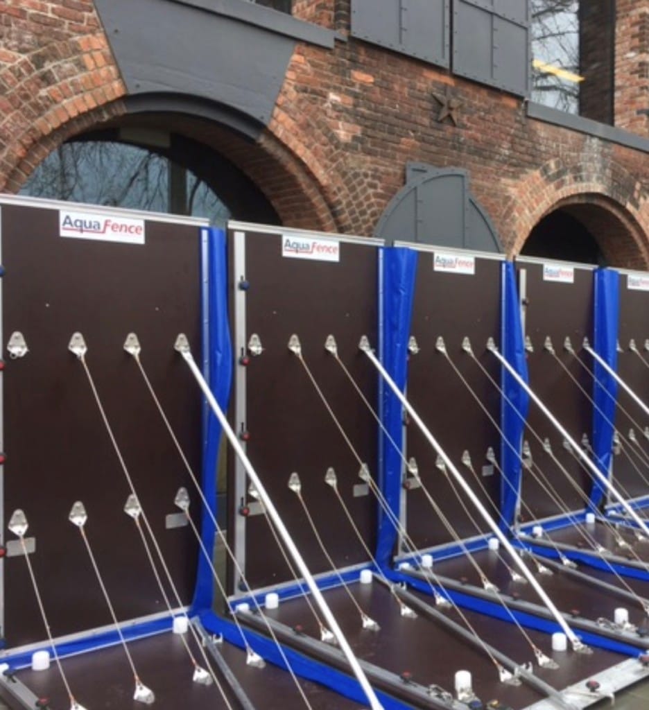
Cayre and the team chose to use AquaFence partly because its technology had proved itself years before. The website for the Norwegian company that makes the flood barrier showcases deployments at office towers, factories, and a low-lying international airport.

“For us it was going to be this dam system that would keep the water away from the building,” says Cayre. “It was something that our construction and engineering people felt very strongly would give them the highest level of certainty in terms of it having a track record and being tested.”

Having agreed that it would cost way too much to try to repair the shutters, the development team appreciated the AquaFence’s simplicity. They test it twice a year for a day-and-a-half at a time, says Cayre. He sees training staff in its use as no more complicated than a fire drill.

Beyond the assurance these demonstrations provide, Cayre says the fence’s separation from the main structure kept costs and complexities from disrupting the project. Indeed, he describes the cost of installing, removing and storing the fence a “rounding error” and says existing staff can handle the testing and deployment without trouble.

The fence’s portable nature also helped keep construction on schedule. “Once we made the decision to do something not connected with the building, construction continued while were doing the research into the AquaFence,” Cayre says. He adds that the total project costs with the fence looked similar to early estimates.

Lenders endorsed the approach. The development team borrowed $280 million from AIG in 2013 for Empire Stores and $217 million for refinancing from M & T in late 2017.

The Hard Part: Restoring the Floor, Securing the Fence

Settling on the AquaFence as a protector set the team to engineering the site. That led to another challenge: restoring the water-worn floor.

As Valgora explains, 150 years of moisture and compaction had made the original packed-dirt floor into something less than a floor. So, before they could bulwark the site’s foundations from the waters that would soak it in a storm surge, the team actually had to create a foundation. “Originally, they were just timber soaked in creosote; There was no foundation. The only thing holding them up was 150 years of soil compression from holding hundreds of millions of tons of coffee beans, and that wasn’t going to work.”

Getting underneath the columns to create a new concrete floor kept the engineering team working overtime. They succeeded, though, in preserving the upstairs floors and walls. “The walls have the natural architectural character and beauty of the building,” Cayre says. “And if a flood did get in there [the walls] are not going to be damaged at all.” Higher up, the team installed an on-site generator. “There was space behind a historic facade where we were able to tuck in a generator on the fifth floor and not have it be visible from the outside,” says Cayre. (Rooftop mechanicals have become almost common in New York City after Sandy but would not fit the silhouette or mood that Empire Stores’ team had chosen.) This, he says, defines a backup strategy in the event that AquaFence or the pump system fails. “We think tenants would be up and running in weeks if not days.”

That backup plan, which experts call “redundancy,” defined a key benefit for tenants whose work lives flow over the Internet. Cayre says the backup generator can run “24/7,” provided a truck can deliver fuel to it. He also says that even after Sandy, trucks were able to travel on Water Street’s elevated grade.

Tenants, then, could potentially work through recovery from a disaster with no damage to anything permanent. “Business continuity came up with tenants who were touring the space,” says Cayre, “and we were able to very quickly put their concerns to rest.”

These include West Elm, which leased a third of the place and whose designers mock up new furniture in an office and whose retailers sell it on the ground floor. They also include Newell Brands, whose managers market smoke detectors, vacuum cleaners and other household staples. Brooklyn Historical Society even took space for a new gallery, showing confidence that their archived material would stay dry and accessible.

Today, Cayre says, the site draws people to the roof and from the park all day and has become a creative and community hub. “It’s really been as great as we could have hoped for,” he concludes. And he says he’s confident that three layers of security- the fence, the stone walls, and finally the generator- will keep it buzzing no matter what weather lies ahead.

Lessons Learned

If your main resilience challenge involves flood protection, you can invest in protections that don’t complicate your main building. By zeroing in on a dam-like strategy, Midtown and HK could satisfy lenders’ concerns about insurability and tenants’ concerns about business continuity without getting into the messy details of retooling a historic structure.

A new technology, if you can test it, can serve a historic site. The team hid its onsite generator to sustain their building’s historic character and keep the AquaFence tucked away. Other teams working in landmarked or distinctive areas may also choose resilience strategies that emphasize reliability over aesthetics or ingenuity.

Even in a world with superstorms, a site that engages the water’s edge can command a premium. Empire Stores opened years after Sandy, while news about climate change became more conclusive. Locals and tourists over the same span have made Brooklyn Bridge Park’s lowlands a New York City highlight. They pose for wedding pictures, schedule after-work parties, buy sofas and suits, and work long hours by the waterfront. The rolling edge and vista, and the convergence of old warehouse construction with new protections, make Empire Stores resilient to fads as well as storms.

FDR Park Master Plan

Context

Originally called League Island Park, FDR Park was designed by the Olmsted brothers (sons of Central Park designer Frederick Law Olmsted) in 1914. The 348-acre park is located in South Philly, one of the city’s most densely populated and diverse neighborhoods. FDR Park is currently well used, but has not seen significant investment in decades. Some park facilities have been closed to the public due to disrepair while others, like the 18-hole golf course, are no longer viable in the face of changing climate and recreation trends. The master-planning process was a chance to restore the designers’ original vision of the park as an urban oasis while adapting to the needs of present and future Philadelphians.

As Philadelphia’s only estuary park, FDR owes its existence to human intervention; fill material from the construction of the nearby Broad Street Subway line was used to convert the original tide marsh into usable park space. Today, the transformed landscape is still shaped by its proximity to water and tidal influences. The park also receives unfiltered stormwater from adjacent impervious surfaces, including I-95. Much of the park lies below sea level and water can drain out only when the Navy Basin is at low tide. Consequently, the park floods often. A tide gate installed over 100 years ago has struggled to drain the park effectively. As a result, trails, roads, and other amenities in the park show signs of significant flood damage.

Climate projections indicate that Philadelphia could see four to 10 times as many days above 95° F by 2099 and average summer temperatures could increase by 5° to 9° F. Average annual precipitation could increase by five inches by 2099. In a business-as-usual emissions scenario, local sea level could rise by as much as four feet by 2100. The park is an important natural asset for the city and has been identified as a resilience hub by the National Fish and Wildlife Foundation. Resilience hubs are open spaces located near infrastructure and population density, where communities can maximize return on investment and achieve multiple community resilience and conservation outcomes.

“This plan is the act of balancing water, nature, and activity.”—Allison Schapker (Fairmount Park Conservancy)

The master-planning process began in 2017 as a joint effort of the Fairmount Park Conservancy, Philadelphia Parks and Recreation, and Friends of FDR Park. WRT was selected from 15 proposals to complete the master plan, which was funded by the Friends of FDR Park, a grant from the William Penn Foundation, and City Councilman Kenyatta Johnson’s office.

The master planning process included an in-depth hydrological study of the area, made possible by the William Penn Foundation funding. Most of the park sits in a 100-year floodplain and the park is also located in the drainage area for three combined sewage overflow discharge points into the Delaware and Schuylkill Rivers. With these risks in mind, the project team needed a complete understanding of how water flows into, out of, and through the park. The study tracked how water moves between the park’s creeks, lakes, and lagoons, and its findings informed the proposed placement, location of amenities and design of the stormwater management infrastructure.

Community engagement was a critical component of the master planning process. The team engaged community members through public meetings, hands-on workshops, and surveys. In-park engagement included mobile planning booth with opportunities for residents to give feedback by designing their ideal park.  The project team also hired 5 park ambassadors from the surrounding neighborhoods, to engage park users and their fellow community members. With 19 different languages spoken in the census tracts bordering FDR Park, much of the engagement work was done across multiple languages and cultures.

After a one and a half-year planning process, the master plan was revealed on May 22, 2019.

Innovation

The master plan envisions a park that serves both people and nature. Its design is delineated into two zones: the Urban Edge and the Ecological Core.

The Ecological Core proactively acknowledges the park’s flood risk by increasing the park’s capacity to manage water while simultaneously providing opportunities for visitors to connect with nature. “Mother nature will do what it’s going to do, and this park will flood,” said Charles Neer, senior associate with WRT. “We want to create a park that responds to the needs of mother nature and users.” Expanded creek systems and restored wetlands in the Ecological Core are designed to accommodate flood and stormwater, facilitating its storage, filtration, and movement through the park while providing a chance for visitors to connect with nature.

The planned wetland mitigation and stream restoration projects will produce a significant amount of fill material. The master plan proposes repurposing this material to create The Hill, a 36-foot elevated section of the park that will provide views of the city skyline and additional recreational opportunities. Fill material will also be used to elevate athletic fields and other amenities in the Urban Edge out of the floodplain.

The planning team often refers to FDR park as a “bathtub” due to its topography and tendency to store water. If the park is a bathtub, then the tide gate is its drain. In recent years, the tide gate and its associated system of culverts have not been effectively draining water out of the park. Replacing the tide gate is a top implementation priority.

Amenities in the Ecological Core are also designed with potential flooding in mind. Asphalt trails, which tend to deteriorate with prolonged water exposure, will be replaced with wooden boardwalks. Picnic areas will be elevated to ensure their continued use; an important consideration in Philadelphia’s most popular picnic site.

“The park needs to be flexible to a rate of climate change that we can’t predict anymore. We can’t engineer out of this situation, but we can adapt.” – Charles Neer (WRT)

The Urban Edge encircles the park, providing an attractive and welcoming interface with the community. “The park itself is a place of climate refuge [from extreme heat],” says Alison Schapker, director of capital projects at the Fairmount Park Conservancy, and the Urban Edge welcomes visitors with abundant shade and a network of green stormwater infrastructure, designed to manage runoff from the surrounding urban areas. Twenty acres of the park will be reforested with species like sweetgum that are expected to thrive in a hotter, wetter future. The master plan team also worked with Philadelphia’s Office of Sustainability, Water Department, and Floodplain Manager to analyze impacts of climate change, flooding and sea level rise.

Stormwater management interventions within the park are designed to exceed PWD stormwater management goals by managing surface runoff from outside park boundaries. Green stormwater infrastructure is proposed near the northern and southern borders of the site to manage water coming from surrounding roads.  This is especially important near Interstate 95, where 15 acres of untreated highway run off onto the park, creating significant maintenance issues within the park. Natural filtration systems ensure that the park can accept stormwater from the roadways without degrading water quality in the Park’s lakes or impacting park infrastructure

The City’s Green Plan, a long-term vision for the citywide open spaces, suggests the creation of green streets surrounding the park that act as neighborhood cooling corridors and comfortable park access routes. Although FDR is the only large park in Philadelphia that is directly connected to a subway station, most visitors arrive by car. The master plan aims to make FDR park a destination for walkers and bikers, both by improving trail systems within the park and by creating more welcoming entrances for alternative transportation.

The Urban Edge will also be home to the park’s recreational amenities, including athletic fields, playgrounds, pavilions, and comfort facilities. Some of these amenities will be elevated to ensure their continued use during flooding conditions.

The master plan anticipates the projected impacts of climate change and envisions a park that not only retains its recreational value in a hotter, wetter future, but also actively mitigates the impacts of higher temperatures and more frequent flooding. The park’s mitigative capacity extends beyond its borders, providing essential services to the surrounding area.

Value Creation

FDR park can only provide environmental, recreational, and economic benefits to the community if it is adequately funded and maintained. Concurrent to the development of the master plan, the team worked with the City and recreational consultant Greenplay to develop an operations and maintenance plan and operating proforma for FDR Park. As a result, the master plan reflects the importance of creating a self-funding park that balances opportunities for revenue generation with access and equity. If successful, FDR Park will be the first self-sustaining park in the city, generating enough funds to cover its operations, maintenance, and staffing costs.

According to Schapker, “Many of the things people the community are asking for will generate revenue for the city,” including bike and boat rentals, trails, athletic fields (which generate tournament fees), and food vendors. The 15-acre Great Lawn may host events while the multi-use trail also doubles as a 5k course. The master plan also anticipates ways that the park could capitalize on its proximity to three of Philadelphia’s major sports venues: the Wells Fargo Center, Lincoln Financial Field, and Citizens Bank Park by offering parking and dining opportunities for fans.

Maintaining consistent staffing is also integral to the overall resilience of the park. As Neer explains, “When the park has dedicated staff, they will be more aware of the environmental situation. What’s working? What’s not? They will be able to calibrate and schedule use of the park accordingly.” With a consistent revenue sources, the master plan hopes to make dedicated staffing possible.

Next Steps

The first phase of implementation will include the creation of almost 40 acres of wetland on the park’s southwestern side, completed in partnership with the Philadelphia International Airport. With the creation of a mitigation wetland in FDR Park, the Airport will be able to pursue its own development projects while also improving the hydrologic function of FDR Park and providing fill to elevate new amenities out of the floodplain.

As of July 2019, funding remains to be secured for the remainder of the master plan. The project team anticipates it will be funded with a mix of local, state, and federal funds as well as private corporate and philanthropic partnerships.

FDR Park is an example of a public/private partnership; an example of civic investment; and an example of climate resilience. The opportunities in all of those areas work together rather than against each other.” – Allison Schapker (Fairmount Park Conservancy)

Although it may be years before this new vision for FDR Park is fully realized, the master planning process provides an exciting path forward for the creation of a park that is vibrant, self-sustaining, and resilient, that can serve as a blueprint for park development in Philadelphia and beyond.

Sources

District Wharf

Developed by PN Hoffman and Madison Marquette, with partners E.R. Bacon Development, City Partners, Paramount Development, and Triden Development, The Wharf is a public private partnership with the District of Columbia’s Deputy Mayor for Planning and Economic Development. It is an ambitious project that has transformed what was once a low-density, commercial development strip into a bustling mixed-use quarter. Proactive investments in resilience and sustainability were key components of the development team’s proposal for this high-profile site. A strong vision for a sustainable urban waterfront helped the development team secure the site and advance this high-value project.

The Wharf’s 3.2 million square feet of development are located on 27 acres of land and 49 acres of water along roughly one mile of the Washington Channel. The $2.5 billion mixed-use neighborhood integrates many innovative ideas in waterfront design, construction, and operations. These elements include extensive and intensive green roofs, parks, and public spaces that manage stormwater beyond the District’s current requirements, cisterns to collect water for onsite re-use, a cogeneration plant for energy production, roof top solar panels, and a promenade and piers designed to resist storm surges and flooding. The revitalization project also is advancing economic and social resilience by providing opportunities for increased tax revenue for the city, high quality jobs, affordable and workforce housing, open space, recreation opportunities, and connections to nature in Southwest D.C.

The Phase 1 development of apartments, condominiums, retail stores, offices, hotels, restaurants, performing arts hall, and parking, as well as the waterfront park, promenade, and piers, was completed in the fall of 2017. Phase 2, in which broke ground mid-2018 and will complete in 2022, will include additional office, hotel, retail, restaurants, parking, marina, and residential development as well as significant public space improvements.

Mitigating Risk

From the start of the project in 2006, master developer Hoffman-Madison Waterfront and architects Perkins Eastman focused the design process on sustainability, authenticity, and connectivity. The previous 1950s-era commercial district on the site was composed of one to three story buildings housing large format restaurants and a motel. The buildings formed a near-continuous wall along the waterfront that blocked quality public access to the water’s edge. The Hoffman-Madison team leveraged the site’s location close to two Metro stations served by five metrorail lines to create a multimodal walkable, bikeable, and transit-accessible neighborhood, with full access to the riverfront and a new transit mode: water taxi, with service to other waterfront locations along the Potomac and Anacostia Rivers.

The Wharf features a permeable development pattern—an urban grid with a walkable waterside promenade with frequent openings to Maine Avenue, the waterfront’s main arterial. The waterside Wharf Street, a woonerf-style shared street, is the ‘spine’ of the neighborhood, connecting apartments, offices, hotels, restaurants, shops, a 6,000-seat indoor performing arts facility called The Anthem, the historic municipal fish market, a food pavilion, and underground parking for 2,500 vehicles. The urban fabric is connected by 14 acres of public spaces, including a waterfront park, four new piers, a new marina, yacht club, and recreation pier for launching kayaks.

The master plan focused on “bringing the connective city to the waterfront,” with the greatest challenge being “on one hand, calling for buildings to be built up above the 100-year flood plain, and on other hand, permitting people to interact with the riverfront,” notes Perkins Eastman Principal Hilary Bertsch. The commitment to sustainability and resilience, she says, is found in the design focus on connectivity within the site, making development parcels smaller for better permeability to the waterfront, and public space that constitutes half the site and provides systems to recycle stormwater.

Along the water, the property line is set back 20 feet from the previous development line to increase resilience to flooding and create placemaking opportunities with a 60-foot-wide promenade. Buildings are elevated an additional 1.5 feet above Federal Emergency Management Agency requirements. Some facilities, such as piers and the marina, are “designed to get wet” in extreme events. While the majority of the newly developed buildings have been brought above the floodplain, a renovated historic building and other new structures at the historic Maine Avenue Fish Market rely on floodgates and panels during major flood events due to the existing grading of the site, which could not be modified.

“The public environments are where we’ve incorporated a lot of those sustainability and resilience features, using really robust materials, things that are going to last,” says PN Hoffman Vice President Matthew Steenhoek. “From an investment perspective,” he says, “we are not merchant builders, and we spend upfront money on beautiful buildings and systems that have a longer payback.”

The Wharf neighborhood is equipped with multiple on-site energy conservation and production sources, including a cogeneration plant and solar panels. A natural gas 250kW microturbine cogeneration system installed atop The Wharf’s largest residential building decreases the draw of local power, which is primarily coal-derived. The microturbine generates continuous, reliable, and low-emission electricity which will service constant electrical needs in the below-grade, two-level garage for lighting, exhaust fans, sump pumps, elevators, emergency power systems, and public restrooms. The electricity produced on-site reduces the cost of purchasing approximately 1.9 million kWh of electricity from the local utility, resulting in a significant annual savings. In addition, the 1.2 million Btu/h of ‘waste heat’ created in this process is used to heat domestic hot water for the residential building, resulting in an overall efficiency of 64%. Lastly, the cogeneration system generates fewer CO2 emissions than conventional coal-fired power generation, resulting in a CO2 reduction of over 1,400 metric tons per year.

The site’s stormwater management system is designed to capture 3.2 inches of rainwater on site. This value is more than twice 1.2 inches required by the city’s Department of Energy and Environment stormwater retention requirements, which are among the most progressive in the nation. About one-third of the site is permeable, compared to 10 percent of previous development. Green infrastructure includes living roofs that cover half the buildings, permeable cobblestone paving, and rain gardens in the parks. Mature oaks were preserved, and 300 new trees are being planted. Three large cisterns housed in underground garages can manage up to 700,000 gallons of stormwater, diverting untreated runoff from the river channel. In the past year, around 547,000 gallons of the stored stormwater was filtered, treated, and used for landscape irrigation, toilet flushing in public restrooms, and make-up water in the co-generation cooling tower.

Creating Value

The Wharf is designed to achieve LEED® ND-Gold rating in the U.S. Green Building Council’s Leadership in Energy and Environmental Design for Neighborhood Development program, with individual buildings achieving Gold or Silver ratings. The plan exceeds many of the requirements of the District’s Green Building Act and the Anacostia Waterfront Initiative. Sustainability was always a critical component of the project and was emphasized throughout the project’s Planned Unit Development (PUD) process with the D.C. Zoning Commission.

The extensive investments in energy and water efficiency are also projected to reduce operational costs. All stormwater will be reused on site, decreasing the need for potable water for landscaping and other purposes. Financial returns include savings on energy; at operating capacity, the micro-turbine will recover approximately 1.2 million BTUs to generate hot water, which translates to a minimum 5 percent in energy-cost savings.

The project also presents economic development and tax base-expansion opportunities for the District. At full buildout, the development is projected to create 7,200 permanent jobs and during the construction of Phase 1, over 8,500 people worked at the Wharf. The project’s for-sale real estate, retail, restaurants, entertainment venues, and recreational services will produce significant annual tax revenues for the city.

Upon completion, the Wharf we be home to approximately 2,100 residents. Social returns include new affordable and workforce housing comprising one-third of the approximately 900 rental units in Phase 1 and Phase 2. Half of the affordable units are reserved for households earning 60 percent of area median income (AMI) or less, and half are reserved for households earning 30 percent of AMI or less. The depth and breadth of the Wharf’s affordable and workforce housing program greatly exceeds the Inclusionary Zoning requirements elsewhere in the District.

The developers aim to employ District residents in at least half of the created construction and service jobs and have targeted purchasing 35 percent of needed goods and services from local sources and establishing a 20 percent ownership stake in the project through Local, Small, Disadvantaged Business Enterprise participation. In Phase 1, this translated to more than $388 million in goods and services going to the local targeted businesses. The new parks, open space, and recreational facilities offer many opportunities for healthy and active living and social gatherings, important aspects of a sustainable neighborhood.

The neighborhood’s diverse mix of hotels, culture, and businesses with affordable, workforce, and market rate housing is unusual in a “world class waterfront development,” says Elinor Bacon, president of E.R. Bacon Development. She notes that outreach efforts such as inviting local residents to help design the waterfront park and a free apprenticeship program that trains public housing residents for construction jobs have engaged the local community.

“Social equity and community contribute to resilience,” says Bacon. “Strong culturally diverse communities in which people know, respect, and care for each other build social structures that strengthen the fabric of community. This is something that drives us. These principles and strategies exemplify our community engagement at the Wharf.”

Meander Bend Park

Context

The goal in using TBL software was “to focus on the projects that give us the highest benefit,” said Marie Light, program manager for the Pima County Department of Environmental Quality. The idea was to design one park as a test case for the TBL analysis before using the software for other green infrastructure projects across the county.

In total, the TBL cost-benefit analysis for Meander Bend Park yields an estimated $9.8 million in TBL net present value (NPV) over 50 years. The TBL NPV is a result of quantifying the value of the social and environmental benefits of the resilience and sustainability features in the park design less the value of project costs. Some of the social and environmental factors considered in the analysis include property value, risk reduction, and recreational value. Capital expenditures as well as operation and maintenance (O&M) costs are subtracted from the TBL NPV as project costs.

Pima County chose Meander Bend Park as the pilot because of its location; in a high-temperature/low-tree-canopy area, the creation of this park will create a pleasant recreation area for residents of the nearby middle-income neighborhood and users of the Loop, an adjacent regional biking/walking trail.

“Understand that sustainability isn’t ‘a nice to have.’ Sustainability can have demonstrable impacts on your own bottom line, so you need to consistently value the broader benefits.”—Simon Fowell, Economist, Autocase

Meander Bend Park is located along a bend in the Santa Cruz River that was isolated during the 1980s by a bank stabilization and floodwater control project. This meander in the river was not required to carry the floodwater volume; therefore, it was cut off from the main river channel, leaving a large void. The Regional Flood Control District partnered with landscape architecture Wheat Design Group for the design and with analytics specialist firm Autocase to analyze the proposed plan.

After the TBL analysis was complete in early 2018, the Regional Flood Control District began filling the void with sediment dredged from the river, which has the additional benefit of increasing the river’s flood capacity. As soon as the void is full, the county will begin installing the planned stormwater harvesting infrastructure, vegetation, and amenities.

Even though construction of Meander Bend Park is not yet complete, the climate-aware TBL approach and the new site plan demonstrate methodologies and best practices that can be incorporated into a variety of green infrastructure and landscaping projects.

Innovation

A New Model for Climate Projections
Instead of following the standard process of using temperature data from the past 30 years, Autocase built a new model to calculate social, environmental, and economic benefits under projected climate conditions 30 years in the future.

Arizona is one of the fastest-warming states in the United States. Pima County’s average temperature is 2°F warmer today than its pre-industrial average, and property damage from dangerous heat days, severe storms, flooding, and other extreme events amounts to more than $9.4 million in Pima County each year.

The team worked together to define assumptions and gather the data necessary to build a model that would realistically represent future climate. First, they chose a high-emissions scenario (IPCC RCP 8.5) in which there is little to no climate policy action and high rates of greenhouse gas emissions. Next, specific regional values for the climate model were drawn from NOAA data sets and from research conducted locally by University of Arizona scientists. The county and district contributed localized information so that Autocase could successfully model not just future climate but small-scale microclimates (and stormwater and rainwater harvesting capacity) created by the variety of desert and mountainous landforms in and around Pima Country.

Urban Heat Island Mitigation
Incorporating future climate was key to accurately pricing the benefits of urban heat island (UHI) mitigation. While it is becoming more common to consider the long-term impacts of UHIs on infrastructure, comprehensively internalizing the mitigation benefits remains a challenge.

An essential step was determining how the park design would reduce temperatures (as well as energy use) in the area. The software then uses the relationship between temperature and heat stress to measure the factor by which mitigation reduces heat mortality. With green infrastructure, Autocase economist Simon Fowell elaborates, “there’s a lower likelihood of people falling ill from heat stress.”

Climate and User-Aware Landscape Design
Another unique aspect of this project was that the team had the opportunity to understand how each of the design features would affect the overall climate performance of the park. The team used the TBL cost-benefit analysis software to evaluate the upfront capital and O&M costs of different storm- and rainwater management options.

The opportunities to make changes—such as increasing the size of an infiltration basin and including tree species with wider canopies to increase shade cover—also improved the final performance.
Part of the TBL analysis includes social factors such as the number and types of visitors to the site. “That makes you think, ‘What kind of amenities should I be using to get more visitors there?’ or thinking about different seasonal amenities so someone can comfortably use the site every day of the year,” says WDG designer Alex Stoicof.

When complete, Meander Park will have native vegetation for shade and food production, infiltration basins, a rainwater harvesting ramada and cistern, vegetated swales, places of respite, and a connection to the Loop regional recreation trail.

Value Creation
The results of comparing the value of the green infrastructure plans under current and future climate scenarios are striking.

“What we found was that the benefits of green infrastructure are twice as large when you factor in climate change and future temperature projections.”—Simon Fowell, economist, Autocase

The Autocase analysis for Meander Bend Park shows an estimated $9.8 million in triple-bottom-line net present value of social and environmental benefits over a 50-year time horizon relative to the base case scenario. The value of heat island mitigation is the second-most contributing factor in this analysis, with an estimated value of $1.8 million over 50 years under the RCP8.5 climate scenario. Even under a “business as usual” scenario using historical temperature data, UHI mitigation is valued at $0.9 million.

The combination of drought-tolerant landscaping and the inclusion of a water harvesting ramada also eliminates the need to import irrigation water. This self-reliance is critical in Tucson, where the potable water supply is at risk due to regional water shortages and drought. In response, Evan Canfield of the Regional Flood Control District explains:

“It is important to develop designs that rely on locally available water supplies like rainwater and stormwater, while still providing amenities to the community.”—Evan Canfield, civil engineering manager, Regional Flood Control District

In total, the TBL results of the green infrastructure stormwater design (considering factors such as capital expenditure, water costs, water quality benefits, and others) show environmental and social benefits that are over six times the cost of capital expenses and operation and maintenance.

The public has responded positively to the level of detail in the analysis. Pima County administrators concerned about municipal credit ratings have also been pleased to see proactive action to account for extreme weather.

Even though the majority response has been positive, there are some who are wary of the triple-bottom-line approach because it is a departure from the traditional method of evaluating green infrastructure on a per-unit basis. However, “it’s really hard to get a per-unit cost,” explains Marie Light, because “the value of above-ground green infrastructure depends on its location within the urban area.”

Meander Bend Park was just a test case; Pima County is creating and evaluating plans for other park renovations using the TBL-CBA approach and the climate projection model developed during this project.

Lessons Learned

  • The value of green infrastructure will likely increase under future climate projections. While there is a return under current and future climate conditions, the triple-bottom-line analysis found the benefits of green infrastructure to be twice as large for this pilot project when considering climate change and future temperature projections.
  • Consideration of climate impact and user experience leads to different landscape design. Understanding the climate hazards and the criteria by which a design will be evaluated can improve the overall performance and value of a park.
  • Accurately valuing urban heat island mitigation is a challenge and an emerging specialty. There are still many unqualified factors. Expect continued refinement and sophistication of the tools to meet the increasing demand from the public sector to quantify the benefits of mitigating extreme temperatures.

Resources

  • Interviews with: Alex Stoicof, designer, Wheat Design Group; Evan Canfield, civil engineering manager, Regional Flood Control District; Interview with Marie Light, program manager, Pima County Department of Environmental Quality; Simon Fowell, economist, Autocase.
  • Autocase. Triple Bottom Line Cost Benefit Analysis of Green Infrastructure for a Proposed Meander Bend Park and the Southern Arizona’s Children Advocacy Center for Pima County. 2018.
  • Garfin, Gregg, Guido Franco, et al. “Southwest.” Climate Change Impacts in the United States: The Third National Climate Assessment. 2014.
  • Bakkensen, Laura A., and Riana D. Johnson. “The Economic Impacts of Extreme Weather: Tucson and Southern Arizona’s Current Risks and Future Opportunities.” Making Action Possible in Southern Arizona. 2017. Online.

Park 8Ninety


Introduction

Getting stuck at the office over the weekend took on an entirely different meaning for employees of Rexel Inc. during Hurricane Harvey. They were scheduled to open a new regional office and warehouse at Park 8Ninety in Missouri City in September 2017. On Saturday, August 26, the rains came—and did not let up for four days.

Park 8Ninety is a business park in Missouri City, Texas. (Powers Brown Architecture) First, the sunken highway interchange out front filled with water; elsewhere in town, two tornadoes struck offices and homes. Then, water began backing up in some of the roads—but then stopped, well short of the front doors or even the cars in the small parking lot. Nobody could leave because even the elevated highways were only reachable via flooded roads, but at least the staff, the new furnishings, and the valuable inventory were safe inside. By the time the sun came out August 30, roads were clear, the detention basin’s channel was dry, and the new offices could open on time.

The $4 million drainage system installed at Park 8Ninety “still worked with 50 inches of rain,” says Dan Muniza, vice president at developer Trammell Crow. “Our tenants were high and dry—including the ones trapped in the property during move-in.” A partnership between the developer and the city ensured that the rain was safely diverted 1,000 feet away—to a newly dug lake at the popular Buffalo Run Park. The park’s lakes kept more than just the business parks dry: an adjacent high school also became a refuge during the storm, taking in more than 600 residents displaced from their flooded homes.

The Site and the Idea

Park 8Ninety fills 127 acres in the southern quadrant of the intersection between Beltway 8 (Sam Houston Parkway and Tollway) and U.S. 90 Alternate (U.S. 90A), a limited-access continuation of Houston’s South Main Street. The site is 13 miles from downtown and ten miles from the Texas Medical Center, the world’s largest medical complex, with over 100,000 employees.

The beltway’s opening in 1997 gave the area much-improved, stoplight-free access around southern Houston to the Port of Houston east of the city, the nation’s largest port by tonnage, as well as to the two international airports and the Energy Corridor business center on the city’s west side (see ULI Case Study: CityCentre Houston). The additional connectivity sparked growth among industrial facilities in the southwest part of the region, an area that had mostly been bedroom communities.

In 2007, Trammell Crow purchased the defunct Willowisp Country Club just south of Park 8Ninety and redeveloped it as Lakeview Business Park, building off the success of nearby industrial development. A residential developer had been interested in that site, given the boom underway at the time, but Trammell Crow convinced the city that industrial development presented greater opportunities to expand its tax base and create local jobs.

“We predicted the industrial market moving in that direction,” says Jeremy Garner, principal at Trammell Crow. “We saw demand expanding south of the beltway.” Today, Lakeview has over 1 million square feet of industrial space, including facilities for Niagara Bottling, Southwest Electronic Energy, and Bimbo Bakeries USA.

Trammell Crow, which began operations in 1948 with a speculative industrial park in Dallas, today is the largest commercial real estate developer in the United States, with almost $8 billion in projects in development. (ULI published a biography of founder Crow in 2005.) Today, it is the development services arm of CBRE, a Fortune 250 commercial real estate services and investment firm.

Planning and Design

Ultimately, Park 8Ninety will contain a total of 1.8 million square feet of space in up to 13 buildings. The site is bisected by a Texas Department of Transportation (TxDOT) drainage channel, which conveys water from U.S. 90A along the site’s northwest boundary to the Cangelosi Ditch, the site’s southeast boundary.

Buildings. The first phase consists of 440,000 square feet of space in three single-story buildings at the front of the park, closest to the intersection of Beltway 8 and U.S. 90A. Two buildings (Buildings 1 and 2) are 160 feet deep and bracket a rear truck court; the larger Building 3/7 is 200 feet deep and 1,620 feet wide, with a front truck court. Four additional 160-foot-wide buildings are planned for the park’s front half. All of these structures are appropriate for either warehouses or flex space: multiple frontages allow for windowed offices in front of or beside warehouses; storage racks easily fit under high-cube ceilings with 28 or 32 feet of clearance and bays up to 52 feet wide.

The park’s back half, west of the TxDOT channel, is planned to include five substantially larger warehouses. Three are planned as cross-dock warehouses (with loading docks on both sides), and two are flex buildings with parking in front and a truck court at the rear.

Despite its choice location, the Park 8Ninety site remained underused for decades; much of it was woods or fields, but part was developed as a golf range in the 1990s. To the west are a few streets of houses built in the 1970s and one site with a colorful history: a racetrack, then a failed Chinese-themed retail center, then a never-built Islamic religious center. This particular site had been eyed for development, but appeared to be impossible to drain—especially since about 40 percent of the site sat below base flood elevation. As Missouri City Mayor Allen Owen explains, “Development [in east Texas] is geared around two things: getting water onto the site and getting water off of the site.” The latter took some ingenuity.

Drainage. Even though the site is traversed by TxDOT’s drainage channel and borders the Cangelosi Ditch, these were both only a few feet deep—too shallow to adequately drain the volume of water coming off the site. Sites in the Houston area must be engineered to convey a storm that drops 13 inches of rain within an hour—a requirement that is being raised in the wake of Hurricane Harvey.

Neither constructing conventional storm sewers just below grade nor deepening the TxDOT channel was physically possible: Park 8Ninety is traversed from east to west (parallel to the ditch) by multiple utility easements—notably two 16-inch-diameter high-pressure petroleum pipelines five feet below grade and high-tension electrical wires above. Trying to detain all stormwater on site would have left much of the site as wetlands, with only unusably small remnants for development.

The solution, hammered out by assistant city manager Scott Elmer and project engineer Mark Sappington, looked beyond the site’s boundaries for a solution involving a nearby park that needed improvements. As Joe Esch, economic development director for Missouri City, says, “We needed a hole, and they needed dirt.”

Most of Missouri City drains southward, toward the Brazos River, but this corner drains to the northeast, into Sims Bayou via the Cangelosi Ditch. In the late 1990s, Missouri City commissioned a watershed-wide master drainage plan from local engineering firm Walter P. Moore that identified a defunct sand mine just south of Park 8Ninety as an ideal regional detention site.

The mine site was purchased in 2000 by Fort Bend County, which built Thurgood Marshall High School on part of it and sold 95 acres to Missouri City for Buffalo Run Park. The two big sand pits were flooded to create three interconnected lakes with a boat ramp, surrounded by almost two miles of trails, three picnic pavilions, an observation tower, a volleyball court, and a playground. When combined with the high school’s adjacent playing fields, the park can accommodate crowds as large as the city’s Independence Day festivities. In addition to absorbing stormwater from adjacent parcels, including Lakeview Business Park to the south, the lakes provide backup irrigation for the school’s fields.

A fourth lake had long been proposed within the park but required additional funding. The developer could dig that lake down to a depth that would accommodate Park 8Ninety’s drainage needs (25 feet) and use the dirt to raise the Park 8Ninety site’s elevation. In addition, a half-mile-long pipe could connect the site to the new lake, underneath the Cangelosi ditch. “We bypassed the ditch and put a 10-by-10-foot box underneath the Cangelosi Ditch,” says Sappington. The pipe “drains into the lake, the lake rises, and spills into a channel, back into the ditch.” The overall approach ”provided a depth of outfall that you could not achieve elsewhere” in a very flat area, he says.

The site’s elevations had been determined from a 20-year-old survey of the ditch’s drainage area, conducted before GPS and lasers allowed more precise measurements. A new survey of the detention basin—at a cost of $50,000, borne by Trammell Crow—found that the ditch’s standing water level was lower than previously reported. This reduced the amount of fill needed to raise the base site elevation above the floodplain, from three feet to two.

Careful attention during grading of the entire site offered another buffer against floods. Wing walls, 30-foot-wide landscape buffers, and ramped parking lots imperceptibly modulate an elevation rise between the roads and buildings—and between the front parking lots and rear truck courts. This subtle rise keeps the buildings dry even when flash floods exceed the conveyance system and spill into streets and truck courts.

Performance, Management, and Marketing

Trammell Crow broke ground on Park 8Ninety’s first phase, with three speculative multitenant buildings, in 2015 and completed the buildings about a year later. In early 2017, the first leases were signed—including one for a space that spanned the existing Building 3 as well as a planned but then-unbuilt extension, Building 7. Speculative construction on phase two will begin soon, and larger tracts within the site are being marketed as further build-to-suit opportunities.

Tenants drawn to the site so far are mostly business-to-business suppliers with regional distribution networks. Some combine warehouses with light manufacturing: Texas AirSystems stores, services, and does on-site final assembly on heating, venting, and air-conditioning systems. Others, like Rexel Inc., have operations that cross multiple uses: at Park 8Ninety, the electrical supplier has one of its two area warehouses, its regional sales office, and a small retail showroom facing U.S. 90A. Half the tenants so far, including anchor tenant VWR International, supply the life sciences industry.

In addition to the prime location, Park 8Ninety offers tenants readily available space—whether buildings or land—in flexible configurations. For industrial users, “most searches begin with available space, not land,” Esch says. “[Trammell Crow was] out of land that could be delivered at Lakeview, but this allowed them to start with spec buildings” that were move-in ready. “Speed to market is the key to attracting tenants,” says Jeremy Garner, principal at Trammell Crow. “Having a shovel-ready site means there’s less uncertainty and allows us to provide prospects with a reliable timeline and costs.”

Missouri City’s flexibility and transparency in dealing with businesses’ varying needs has also been a draw. VWR has 20,000 square feet of chemical storage space, says Muniza. ” We got letters from the fire marshal about what they would do” to train fire department staff on the proposed systems at the park, giving the tenant additional certainty ahead of its major capital investment.

The site’s proximity to Buffalo Run Park and extensive landscaping distinguish it from other area offerings. Companies have picnics at the park and the site, and employees can go fishing or jogging after work.

Management. Missouri City owns the stormwater infrastructure, roads, ditch, and parkland. The Missouri City Parks and Recreation Department performs light maintenance on Buffalo Run Park; heavier maintenance is carried out by the city’s streets department. TxDOT is responsible for its drainage channel across the site, but in practice Trammell Crow mows it along with the rest of the site.

Flood performance. The drainage system’s first big test came on April 15, 2016, even before the roofs were complete on the first phase of Park 8Ninety. Then-record-setting bands of rain pummeled the west side of Houston in what became known as the Tax Day Flood. Six inches of rain fell in 12 hours in Missouri City; other areas saw an inch of rain in just five minutes. The detention lake at Buffalo Run Park, then newly complete and slowly filling, easily absorbed the storm. During and after Harvey, both the Cangelosi Ditch and its receiving stream, Sims Bayou, stayed within their banks. Indeed, Sims was the only bayou in Harris County that did not jump its banks.

Observations and Lessons Learned

Planning for regional detention. Neither the Park 8Ninety site—surrounded by highways and utility easements—nor the Lakeview site could have been developed had it not been for Missouri City’s foresight in creating a master drainage plan, identifying a detention basin, and following through on building Buffalo Run Park. Elmer, previously the city’s chief engineer, says the strategy resulted in a net benefit for the city, with more tax value from the business parks, particularly because the city “managed to partner with the parks department and surrounding agencies to turn these facilities into major, award-winning parks.”

Thinking in three dimensions. Especially in a region as flat and wet as Houston, careful elevation measurements can make a huge difference. A digital survey of the site recalculated the amount of fill needed, reducing the grading bill by a third. Yet changing the topography by raising the site’s base elevation only made sense as part of a wider strategy that included raising some areas and lowering an adjacent area—which could not only detain stormwater, but also provide inexpensive fill. The exceptional depth of the drainage infrastructure, including the pipe and lake, both created the right volume of stormwater detention and allowed the pipes to clear below-grade hazards like the petroleum pipelines and the ditch’s channel.

Working across boundaries. Park 8Ninety itself crosses boundaries—the parcel spans two cities and two counties, and drains onto public land. It took a lot of cooperation, mutual understanding, and a sustained effort by Missouri City to make sure those boundaries did not get in the way. Esch, the economic development director, credits the city’s “competitive edge—to be creative, reduce costs, and create an amenity [Buffalo Run’s fourth lake] that we can sell elsewhere. We can spend that dollar once and see multiple benefits from it.” Digging the lake, says, Elmer, was “something that benefits everybody.”


The above is an excerpt from the ULI Case Study of Park 8Ninety. Read the full text here: https://casestudies.uli.org/park-8ninety/ 

The Avenue

Context

Completed in 2011, the Avenue has an active streetscape that has become a popular destination for visitors, office workers, residents, and students in downtown Washington. The project came out of an urban design study for the disused parcel that previously held the George Washington University Hospital, which was also Square 54 of the original Washington plan.

The project is the result of a partnership between George Washington University and Boston Properties Inc. under a 60-year lease that has since provided funding for the construction of the university’s Science and Engineering Hall and contributed an estimated $11.5 million in annual city tax revenues. The ground lease terms were based on the amount of developable space rather than the possible floor/area ratio (FAR), which led the development team to create a courtyard concept slightly below FAR opportunities. A key requirement for the design of the building was a below-grade loading dock, which also created the opportunity for an interior courtyard above it.

Sustainable design can be found throughout the Avenue. Green and lightly colored roofs absorb less heat than conventional black roofs, thereby decreasing peak roof surface temperature by approximately 40 degrees Fahrenheit. The Avenue also uses a high-efficiency irrigation system and native and drought-tolerant plants, which reduce the amount of water needed by an estimated 62 percent.

Innovative Water Management Features

  • Green roofs. An extensive 8,000-square-foot green roof is spread equally across the office and residential buildings. This green roof system comprises a water retention layer, a drainage layer, filter fabric, engineered soil, and succulent plantings. On the residential roof, more than 300 linear feet of raised planters with tall evergreen hedges shield the pool and terraces from sight and wind.
  • Stormwater treatment and reuse system. Water is absorbed by the green roofs and then sent through interior piping into the stormwater filter, which includes two sand filters, an ultraviolet sterilizer, and an ionizer that kills algae, bacteria, and viruses without the use of extra chemicals. This system allows plants to grow directly in the water feature and requires less maintenance than a standard infiltration system. Water is then recirculated into the 7,500-gallon cistern, which is located underneath the courtyard, within the five-level parking garage below. Irrigation water is pumped directly from the cistern, and all other stored rainwater is continuously pumped through the courtyard water feature and treatment system. The development’s robust stormwater management system for collecting, treating, and reusing rainwater in an inviting courtyard is able to manage an estimated 76,000 gallons of stormwater.
  • Courtyard water feature. The attractive water feature doubles as a stormwater container, holding roughly 15,000 gallons of water that has been recirculated through the cistern and treatment system. The courtyard’s water feature is 100 percent supplied by reclaimed stormwater. The water feature includes aquatic vegetation in perforated planters that allow the roots to provide supplemental filtration.

Value Proposition

The Avenue has been a resounding commercial success. It achieved the highest residential rents in the city for a project of its size and had a relatively fast lease-up: 11 months for 335 apartments. The commercial space also attracted tenants quickly. “By every metric, the project has exceeded expectations,” says Richard Ellis of Boston Properties. Ellis attributes this success to a variety of factors, including the location, the quality
of construction, and the design of the courtyard space. Beyond serving as an attractive public space, the courtyard has enhanced views throughout the development. “There’s no such thing as a bad or back view,” explains Ellis. “Some people look at a green courtyard; some look at a busy commercial corridor.”

“Most of the users don’t think of the courtyard as a stormwater strategy, but it is. And it has created an open space in the interior of a city block that’s really unique.” Richard Ellis, Vice President, Boston Properties

Lessons Leaned

  • The courtyard water feature has provided residents with significant amenity value. The courtyard is an extremely popular amenity for residents, office workers, and members of the public. Beyond improving public spaces, the courtyard also enhances views for residences and offices, thereby contributing to the desirability of the project and the real estate value.
  • Innovative design can create additional water storage capacity. The design team was interested in creating more water storage than was available in the 7,500-gallon cistern. “We were constrained by the size of the cistern because of the premium for parking,” explains designer Matt Langan of Sasaki. Instead of proposing a larger cistern in the parking structure, the landscape architects designed the water feature to be unusually deep, with water circulating in and out from the cistern and infiltration system.

Stonebrook Estates

Context

Adopted in 2011, Harris County’s Low Impact Development and Green Infrastructure (LID/GI) Design Criteria provide detailed guidelines and requirements that enable real estate development projects using LID/GI  techniques to obtain development permits in the unincorporated portions of the county. Stonebrook Estates was among the first in the Houston area to implement LID principles.

Stonebrook Estates developer Terra Visions LLC could have managed drainage on the site by using a six- to seven-acre detention pond, but instead chose to pursue the LID techniques as part of the overall amenity offering for the development. The development entry features a green, landscaped drainage corridor designed to serve as a gateway to the homes. LID features also provide residents with more green space, a trail system, and a water feature that naturally guides stormwater to two 50-foot-wide detention channels that then filter the flows to an interior detention basin. The basin manages the release of water at a rate and quality that is safe for the surrounding environment.

Innovative Water Management Features

  •  Natural drainage system. The natural drainage system at Stonebrook mimics the natural flow of water across a green landscape, directing stormwater into linear and lake-style detention basins; from there, stormwater is slowly released to nearby channels and bayous.
  • Engineered soils. The first inch of stormwater runoff from the development is routed through engineered soil filters that remove pollutants from the runoff and ensure that the development complies with local post construction stormwater quality management regulations. The engineered soil filters (known as biofiltration) are designed to provide a very high filtration rate, thus avoiding surface ponding.
  • Curb cuts and false-back inlets. Roadways are sloped and use “false-back inlets” on the curbs to drain stormwater into bioswales instead of traditional precast concrete storm sewer pipes.

Value Proposition

Randy Jones, Terra Visions LLC principal, describes the LID features as a key part of the development’s sense of place. After Houston’s 2014 downturn caused by falling oil prices, the developer worried the homes would be priced too high for the market. However, although sales volume and absorption were initially lower, the development fared well, with average home prices about 25 percent higher than expected. Jones describes the community as a “complete blend” that was attractive to the suburban Houston market. “It’s on a private street, a gated neighborhood, and well landscaped with LID components right at the front door. When you put all the pieces together, the market likes it,” he explains.

“We could have put a six- to seven-acre detention pond on the far side of the development and gone off without thinking about using the drainage system as an amenity. But the idea was to be different. We chose to use the facility as landscaping and give it a look that’s not an ugly ditch.” Randy Jones, Principal, Terra Visions LLC

The site engineer, Michael Bloom with R.G. Miller Engineers, estimates that the natural drainage system, which is used only in a portion of the development, reduced the site detention requirement by 24 percent, which increased lot yield.

Stonebrook’s natural drainage system was put to the test during the Tax Day Flood of April 2016. Stonebrook received approximately 12 inches of rainfall in a 24-hour period, which is about equal to the 100-year rainfall for the area. The stormwater management system at Stonebrook “functioned better than anticipated given the rain storm intensity,” says Jones. “I was absolutely amazed that the stormwater stayed in the system and didn’t flow into the streets or yards.” The natural drainage system was able to capture then convey the rainfall and runoff, and both the linear and lake-style detention basins successfully released the design flow to the nearby channels and bayous.

Lessons Learned

  • A low-impact development framework presents an opportunity to fulfill market demand for environmentally friendly communities. LID principles inherently include natural amenities that are attractive to homeowners, such as trail systems and open space. Jones described green infrastructure as a key component of a well-rounded community desirable to home buyers.
  • Natural drainage systems can cut costs of drainage facilities. Stonebrook Estates’ drainage corridor is part of the landscape of the community—and is a more cost-effective alternative for the community’s utilities, given the limited access to the drainage piping system.
  • Green infrastructure can mitigate risk and avoid losses. Stonebrook Estates has already survived a major storm, the Tax Day Flood. Infrastructure in this community has proven to be resilient and protected its community members.

Buffalo Bayou Park

How can a park protect a city from extreme flooding? In this video, learn about the park’s design and development first hand from members of ULI’s Houston district council.

Context

After Hurricane Harvey dropped 27 trillion gallons of rain onto metropolitan Houston, Buffalo Bayou Park in the city’s west end was a complete mess. Roiling floodwaters filled the steep channel for weeks after the storm, even as the rest of the city slowly dried out. Lawns, paths, and picnic shelters that had cost tens of millions of dollars just a few years earlier had disappeared beneath the waves. Mountains of silt, looking like desert sand dunes, covered just about everything else.

Some onlookers wondered whether the money and work that had gone into beautifying the city’s keystone river had all been for naught. “No, it’s not a mistake,” counters Guy Hagstette, project manager of Buffalo Bayou Park. “It comes with the territory.”

Sure enough, just days later joggers were back on the trails. Even before the rains broke, the park’s restaurant was back in business, with avocado toast proceeds donated to a relief fund. One week after the rains, park work crews were out in force to clean off silt and pick up trash and fallen trees, and bike rentals had resumed.

The Site and the Idea

Both Houston and Texas were born along the banks of Buffalo Bayou in 1836, when the Allen brothers laid out a townsite where Buffalo and White Oak bayous meet.

The genius behind their settling well inland of the Gulf of Mexico did not become truly apparent until after 1900, when a hurricane flattened the booming downriver city of Galveston. Port traffic relocated up the San Jacinto river, toward Houston, just as the first oil boom brought unprecedented wealth to southeast Texas. The city grew in every direction, and in 1913 commissioned its first city plan from Boston-based landscape architect Arthur Comey , who wrote that “the backbone of a park system for Houston will naturally be its bayou or creek valleys.” Voters subsequently passed a bond to purchase parkland, including the bayou valleys and an army training camp to the west, which became Memorial Park.

The new city was hardly immune to disasters of its own: in 1935, days of relentless rain swept down Buffalo Bayou, killing seven and inundating downtown Houston buildings with five feet of water. The Harris County Flood Control District (HCFCD) was quickly assembled and put on a fast track; by 1938, the federal government had appropriated funds to dam the bayou’s tributaries and to straighten long stretches of the bayou’s channel. Plans for the linear parks went down the drain.

Between 1953 and 1958, the bayou was straightened through the core of what is now Buffalo Bayou Park—west of downtown, between Sabine Street and Shepherd Drive. HCFCD drew up plans to encase the channel in concrete, to further speed floodwaters toward the ocean. But in a rare triumph for conservation, local activist Terry Hershey, longtime ULI member George Mitchell, and their Buffalo Bayou Preservation Association convinced local congressman George H.W. Bush to turn down a federal appropriation for the pavement.

Even as the leafy neighborhoods along the bayou blossomed into some of the city’s most prosperous, the bayou itself lay neglected. Memorial Drive and Allen Parkway, the roads lining the bayou, were widened into forbidding expressways that completely sealed off the park. Within the valley were the bayou’s often-turbulent waters, which claimed the grim title of Texas’s most polluted waterway, plus “an asphalt trail that had withered away, no park benches, oil barrel trash receptacles, no lighting, no amenities,” says Anne Olson, president of Buffalo Bayou Partnership. A few sculptures and memorials were dropped here and there, facing the highways, but the park gained a generally unsavory reputation.

The Buffalo Bayou Partnership (BBP) was founded in 1986 as part of Central Houston Inc., a civic organization dedicated to downtown, as part of an upwelling of civic pride coinciding with the city’s 150th anniversary. From the start, Olson describes BBP as “very capital project driven, not an environmental or membership group,” as it sought funds and coordinated improvements. BBP’s first capital project was Sesquicentennial Park, a 22-acre park and riverwalk through the downtown theater district (see ULI Case Study, Bayou Place). It opened in 1989 and was expanded in 1998—and inspired work on a visionary plan for the entire corridor, convened by BBP and cosponsored by the city, county, and HCFCD. There was an implicit division of labor from the start, with BBP charged with fundraising for incremental capital improvements.

The first two segments were completed downtown, whetting the appetite for a broader undertaking. In 2000, BBP, with the backing of local governments, commissioned a “Buffalo Bayou and Beyond” plan from a group of consultants led by Thompson Design Group and Ecoplan. When completed in 2002 , it outlined a vision to rehabilitate the bayou’s ecology, expand its drainage capacity, improve its value in terms of scenery and recreation, and revitalize adjacent neighborhoods.

The plan’s centerpiece was a ten-mile, 2,500-acre linear park to be completed by 2022, stretching from Memorial Park in the west, through downtown, to the Houston Ship Channel Turning Basin on the east. Flood control was a key rationale for the plan’s promise of a ‘place that manages the impacts of flooding, protecting its people and assets from random acts of nature.” One of its key selling points was that better drainage could reduce flood risk and enable development along downtown’s neglected north edge, with the bayou waterfront as a centerpiece.

The plan was released at a time of blossoming public interest in Houston’s parks. When a large parking lot next to downtown’s convention center came up for sale in 2004, a group of philanthropists convinced the mayor to join a public/private partnership to create a signature urban park, which opened in 2008 as Discovery Green Park. Meanwhile, progress on Buffalo Bayou slowly continued upstream; in 2006, the Sabine Promenade opened, threading the riverwalks beneath the tangle of highway ramps at downtown’s western edge, creating public access to the water’s edge and creating a transition from the urbane downtown riverwalk to the wilder upstream park.

The Sabine Promenade caught the attention of the Kinder Foundation, which had been instrumental in convening the Discovery Green partnership. Rich and Nancy Kinder, who have focused their giving on green space, education, and quality of life in the Houston area, were initially drawn to the idea of improving water quality. They soon recognized the broader potential of extending the Sabine Promenade upriver, activating a network of green spaces across the city’s west side, and began discussing a major gift.

The $30 million gift that resulted made it possible for BBP not only to raise $23.5 million in matching funds for the park, but also to secure public support for the project’s construction and ongoing maintenance. With the funds in hand, the 2002 plan needed to be refined into detailed designs. SWA Group was the natural choice for this job, having designed the Sabine Promenade and even some of BBP’s 1980s plans. Kevin Shanley, then principal of SWA Group, a global landscape architecture and planning firm with a practice in Houston, had long been known around town as “Mr. Bayou” for decades of experience with ecology and flood control along the bayous.

Planning and Design

Buffalo Bayou Park stretches for over two miles along the bayou from Sabine Street at its eastern end, upriver to Shepherd Drive. Just downriver is downtown Houston, and upriver is the prestigious River Oaks area, developed in the 1920s as a mixed-use suburb by ULI pioneer Hugh Potter. It is mostly bounded on the north by Memorial Drive and on the south by Allen Parkway, both six-lane limited-access roads; the park is also spanned by Waugh Drive and Montrose Boulevard, both busy north–south arterial roads. Most of the surrounding land is multifamily, with some large offices such as the Federal Reserve Bank.

A pair of paved upland trails bracket the bayou for the length of the park, connecting to the downtown riverwalks to the east as well as to the popular hiking and bridle trails in Memorial Park, half a mile from the Shepherd Drive entrance. The trails offer multiple options for loops of varying lengths when combined with four new pedestrian bridges spanning the bayou and adjacent streets—two built by BBP, plus the city’s Rosemont Bridge (a pedestrian span adjacent to the Montrose Avenue bridge) and a second level of the Shepherd Drive Bridge, which was built by the state.

The new bridges, along with extensive traffic-calming measures, help improve connectivity from the park to the densely populated adjacent areas: 44,000 households live within a ten-minute walk of the park. Allen Parkway was reconfigured with elements like stoplights, at-grade crossings, and parking-lined service drives, so that the upland trail users no longer confront relentless highway traffic.

The Buffalo Bayou Partnership restored and repurposed the cistern into a public space to house art installations, tours, and meditation sessions.

Highly visited attractions and structures are clustered into the park’s only two large upland areas: the Water Works on Sabine Street and Lost Lake toward the west end. These recreational elements, along with the more elaborate perennial gardens, are set toward the park’s outer edges, high above the water line and closer to adjacent neighborhoods. Even the bridge spans were calculated to clear the base flood elevation.

The Water Works is built atop and around a decommissioned two-acre enclosed drinking water reservoir, now called the Cistern. Facilities at the Water Works include a visitor center and shop, a bike rental facility, and a festival lawn atop the cistern, adjacent to a skate park (built ten years prior) and a play area with nature-themed equipment. Upstream, a smaller visitor center, boathouse, and restaurant overlook Lost Lake, a tributary pond that was “lost” when its dam broke in the 1970s.

Eleanor Tinsley Park is another highly trafficked area, with a broad amphitheater used for large events that draw tens of thousands, like pop concerts and the city’s Independence Day festivities. It also has the park’s only sports field, a sand volleyball court; additional playing fields are available in nearby parks.

More tranquil, reflective spaces along the trails were created around wetland plantings, or seven public art installations. Some complement existing landscape features or sculptures, like the ceremonial grove of trees planted around the Houston Police Officers’ Memorial, or the semicircle of trees and shade structures around the Wortham Fountain. Other artwork was added to the new landscape, like the glowing “Tolerance” statues at the foot of the Rosemont Bridge and the “Monumental Moments” word sculptures that appear in glades along the lower footpath. Others are nature reserves, surrounded by lush landscapes of 14,000 native trees and 12 acres of prairies—selected and planted in partnership with volunteers and established local conservation organizations like Trees for Houston and the Katy Prairie Conservancy. Half the park’s lawns were replaced with native plants.

From the beginning, park elements were designed with water in mind—both floods and droughts. Just after the Buffalo Bayou and Beyond planning process had begun in 2001, Tropical Storm Allison hit the region and submerged many blocks along the bayou. By the time construction on the park began in 2012, the state had just seen its worst-ever year of drought.

The water course was redesigned in order to reverse much of the streamlining that had been made in the 1950s, following intensive study of the bayou’s “fluvial geomorphopology.” Meanders were restored with “flood benches,” like speed humps where fast-moving floodwater can spread out and drop silt and debris. After high water events, cleanup crews can focus their attention on these few locations.

Sunken areas that had been oxbows were restored as wetlands, and small tributaries lost to urbanization were restored as pumped-flow waterfalls, both providing additional habitat and flood capacity. Steep slopes were regraded, improving conveyance and capacity while also opening up views into the valley.

The park’s structures are designed to withstand not only inundation, but also impacts from whatever debris and detritus might wash through. They show off their heavy-duty construction through the use of hardy and submersible materials- like stout rectilinear shade pavilions of board-formed concrete, precast concrete light poles, oversized handrails, and concrete-filled galvanized steel bridge abutments that poke above the 100-year-flood height. These stronger specifications added 15-20 percent to the upfront cost. Everything built into the park, even the trash cans, has foundations anchored far below the surface to prevent them from washing away. Rounded corners, and surfaces tapered into the flow of future floodwaters, protect everything from bridge columns to walkways from erosion. Retaining walls slope downward to allow silt to slough off.

Most of the park’s larger structures have ground floors intended to flood: water came up to the doors of the restaurant, which sits above a boat rental facility that was designed so that water could flow through.

At the same time, the park does not shy away from engaging with the sometimes-turbulent waters. A soft-surface path for walking and jogging threads close to (but at least 12 feet above) the water’s edge, which at times dives 30 feet below the busy streets. Its lower elevation, tree canopy, and white noise from the flowing water result in a setting entirely removed from the city noise above.

One of the few low-lying recreational areas is an expansive dog park, which had been informally established decades earlier and was deemed too important to move. Its water features are filtered through a recirculating system intended to incorporate a nearby manmade wetland.

Designers tackled numerous challenges intrinsic to working within a waterway. Even though the site was now in the middle of the city, utilities had never really been extended into the park; this proved problematic when siting lights, drinking fountains, and other accommodations. The mucky soils underlying the park are ill-suited for structures; the airy footbridges sit on concrete pilings drilled up to 70 feet into the earth.

Performance

The park’s tremendous popularity has surpassed all expectations, instantly creating a regional amenity out of what had been little more than a drainage ditch. During the first year, the two visitor centers welcomed 14,000 patrons; a trail user counter recorded nearly 150,000 visitors in one month. The park’s bridges, with greenery in the foreground and the city skyline just beyond, have become the iconic photo opportunity in downtown Houston. Linking downtown to a park network that stretches up to Memorial Park has increased park visitation all along the corridor, and created a common ground between the divergent neighborhoods on either side of the bayou.

Event spaces have proved particularly popular, in line with the broader trend toward experiential places. A light-and-sound installation in the cistern drew 30,000 people in 2017, despite limited visitor capacity inside the structure. The jewel-box restaurant, which offers a one-of-a-kind “lost in the woods” setting, is booked far in advance for evening special events—helping to sustain a more accessibly priced all-day menu for park visitors.

The restaurant is the largest commercial tenant within the park; food trucks also fill parking courts on weekends and during special events. “We hired a broker to find us a couple of vendors,” says Olson. The selected vendor “had wanted to do a full-service restaurant, but came back and changed it to breakfast, lunch, and special events” in the evening, when park foot traffic is lower. BBP collects a base rent plus a percentage of gross sales.

The park’s completion has been a boon to properties near the park. One early development that sought to take advantage of the new park, the seven-story Riva at the Park condominium, proved so popular during pre-sales that it was redesigned as a ten-story building. An examination of 2015 tax assessment data shows that single-family houses within a ten-minute walk of Buffalo Bayou (both the park and the wilder upriver stretches) were worth 16 percent more than houses within a 20-minute walk.

Flood Performance

After Harvey, “the new parks and trails along our bayous have come back quickly,” says Hagstette, owing to smart design and budgeting decisions. “Money had to be spent” on flood cleanup, he continues, “but it was built into the plan”—namely, the funds set aside for maintenance and repairs. An outpouring of volunteer support after the flood also came in handy, especially for replanting.

Floodwaters rose 38.7 feet at Buffalo Bayou Park’s western end, but the upper third of the park was not submerged for long. The flood’s height was not entirely unprecedented: it was only five feet above the floods on Memorial Day 2015, four months before the park’s grand opening. Yet the sheer volume of water over the subsequent weeks proved problematic; the unprecedented draining of the overwhelmed Addicks and Barker reservoirs down the bayou drowned trees and grasses in the lower two-thirds of the park, as well as many of the park’s resident bats. When the water finally receded, almost 40,000 cubic yards (4,000 truckloads) of silt and debris were left behind, along with eroded riverbanks.

Park features meant to perform double duty as flood storage, including active recreation fields and passive sculptural elements, were submerged for weeks. Resilient systems and networks meant that backups were available for park users to enjoy: for instance, the lower-level footpath was out of commission for months, but joggers were back on the upper-level paths within days. The one attraction that closed for reconstruction and reconfiguration after Harvey was the dog park, whose location within the valley left it vulnerable to repeated flooding that overwhelmed the water filtration system with silt.

Lighting has proved to be an ongoing design and maintenance challenge. LEDs have been a boon in many regards; BBP has taken full advantage of their artistic possibilities throughout the park with moody lamps that track the moon cycle, and with the blockbuster art installation inside the cistern. However, LEDs are essentially circuit boards, which inevitably short-circuit when plunged into muddy water—which still happens, despite countermeasures like mounting electrical equipment within water-resistant fixtures atop the poles, and water sensors that cut off electricity during floods. (The need for flood resistance also explains why the site cannot rely on solar panels, which are also circuit boards.) After each flood, park staff disassemble and clean hundreds of lights and replace hundreds more; newer generations of equipment are improving.

Mitigating erosion and stabilizing both the channel and slopes also will require additional engineering work after Harvey. Riprap, gabions filled with recycled concrete, and coir all hold down parts of the channel, but high-stress areas underneath bridges and opposite outfalls have been difficult to stabilize with roots given the frequency and duration of flooding.

Observations and Lessons Learned

Planning for the Future. The west end of Buffalo Bayou Park is helping inform similar efforts throughout the region. The east end of Buffalo Bayou is much wider and thus less flood-prone, but runs through an area long characterized by shipping, heavy industry, and the attendant environmental justice concerns. BBP has been purchasing property and easements for parks and trails, and is currently in the midst of a detailed planning process for parks and neighborhoods alongside.

Olson already sees that the park will have a very different character, showcasing its wilder landscape alongside the “cultural and industrial heritage of an area that still has a lot of industry. We own some really cool abandoned industrial artifacts, like an abandoned sewage treatment plant, wharf, and gantries,” and hope to incorporate those into the park. In a nod to erosion that affected trails close to the waterway, easements and setbacks will be wider on the east end.

“Equity is a theme that’s a thread in all of our conversations” about the east end, continues Olson, adding that BBP has been involved in the High Line Network of urban parks that reuse infrastructure as a catalyst for equitable development. A wider focus also means broader stakeholder engagement, “new ways to reach neighbors instead of standard boring meetings,” Olson says.

At a regional scale, the Bayou Greenways 2020 initiative aims to fulfill the century-old promise of a county-wide network of bayou parks by expanding on the network established at Buffalo Bayou Park. It will include 3,000 acres of parkland along 150 miles of waterway, and 80 miles of new trails, bringing 60 percent of Houstonians within 1.5 miles of a greenway park. The $220 million initiative was also launched with a leadership gift of $50 million from the Kinder Foundation and voter-approved park bonds.

Lessons Learned

The funding partnership that created Buffalo Bayou Park played to the strengths of each sector: philanthropists’ vision, the public sector’s staying power, and a park conservancy’s flexibility. Strategically, the partnership started with a big vision and a phasing strategy. This planning enabled the leadership gift and political support to catalyze quick action, and impressive results. The Kinder Foundation did not just want a quick ribbon-cutting, they demanded a lasting legacy; their insistence upon understanding, planning for, and sustaining funding for eventual maintenance and repairs has ensured that the park has bounced back after multiple floods.

Designing resilient features into the park was always the intent, but its importance was underscored by flood events that coincided with the park’s planning processes. These decisions have paid dividends not just in the aftermath of frequent floods, but also in dealing with everyday wear and tear: heavy-duty materials and redundant systems help the park manage big crowds, multiple events, and numerous user groups simultaneously. Carefully tending to the vision through construction required careful management by the architects, contractor, and partnership.


The above is an excerpt from the ULI Case Study of Buffalo Bayou. Read the full text here: https://casestudies.uli.org/buffalo-bayou-park/

Bridgeland


The Idea and the Site

The Howard Hughes Company (HHC) is a Dallas-based developer and operator of master-planned communities (MPCs) and mixed-use properties in 14 states. It is a successor of the Rouse Company, a pioneer in MPCs on the “new town” scale, including Columbia, Maryland; Summerlin, Nevada; and the Woodlands, Texas. In its investor materials, HHC says its large-scale MPC business “build[s] small cities that are their own ecosystems and high-barrier submarkets,” resulting in “some of the highest, risk-adjusted return opportunities” among public real estate companies.

Construction on the Woodlands, located 28 miles north of downtown Houston, began in 1966. It opened in 1974, and now has over 115,000 residents across more than 28,000 acres. Its pioneering design, helmed by influential landscape architect Ian McHarg, set a new standard for environmentally sensitive site planning, especially in the Houston region. “Builders found that they could love profits and trees at the same time,” said McHarg in 1975; preserving stands of trees and draining streets with bioswales both reduced upfront expenses and created a unique sense of place. (ULI awarded the Woodlands a 1994 Award for Excellence, and published a biography of its developer, George Mitchell, in 2004.)

As the Woodlands hit its stride in the 1990s, the developer began scouting for new sites elsewhere in the metropolitan area where it could replicate its success for a new audience. Much of Houston’s job growth in recent decades has occurred to the west and north, so the northwest sector along US 290 seemed like a strong bet. Rouse assembled a large site 25 miles from downtown, just beyond several 1980s subdivisions in the Cypress area, which has a well-regarded Cypress-Fairbanks (Cy-Fair) school district and a low crime rate. The site also sat astride the planned route of Grand Parkway (SH-99), a third beltway around Houston whose first leg opened in 1994. Its 2013 extension through Bridgeland, and its 2016 extension through the northern suburbs, offer nonstop access to job centers in the bustling I-10 Energy Corridor (see ULI Case Study, CityCentre) to the south and to Spring and the Woodlands to the northeast. (In 2017, HHC launched a third MPC in the region—the Woodlands Hills, ten miles north of the Woodlands.)

Bridgeland began construction in October 2003, and home sales began in 2006. At buildout, currently estimated for 2037, it will have 65,000 residents on its 11,400 acres. The first of Bridgeland’s four planned villages, Lakeland Village, is almost complete, with 8,300 residents in 3,400 homes; Parkland Village, the second village, opened in spring 2018. Lakeland Village fills most of the northeastern quadrant of Bridgeland, Parkland Village the southeast quadrant, Prairieland Village the southwest, and Creekland Village the northwest. At the site’s center, along Grand Parkway, a future 900-acre Bridgeland town center is planned.

Even by east Texas standards, the site has “no topography, and [has] soil with a high clay content, which means there’s little percolation,” says Heath Melton, vice president of master-planned community residential development at the Howard Hughes Corporation. Combined with the Gulf Coast’s intense summer rainfalls—three inches of rain can fall in 30 minutes, according to Mark Gehringer, senior project manager at Bridgeland—drainage is a key consideration for any potential master plan, and flooding is a risk anywhere, anytime.

Unlike the Woodlands, the Bridgeland site was a relatively treeless, flat, and once-marshy expanse of the vast Katy Prairie west of Houston, but later plowed under for rice farms and used as ranch land. Although the site is almost entirely flat, with a mere 0.05 percent slope from west to east, its sheer size means it outfalls into two primary watersheds. Cypress Creek runs along and across the north edge of the site, flowing from west to east across Houston’s north suburbs. The south edge of the site drains to Langham Creek, an intermittent stream roughly at Bridgeland’s southern boundary that flows southeast into the Addicks Reservoir and ultimately into Buffalo Bayou (see ULI Case Study, Buffalo Bayou Park).

Bridgeland includes much of the 5,000-acre watershed of K150, an intermittent feeder into Cypress Creek that flows generally northeastward through Lakeland Village and meets the creek at the site’s northeastern corner. K150’s streambed is the basis of Bridgeland’s detention, conveyance, and recreational corridor spanning the site from west of the Grand Parkway, east along the north edge of Bridgeland Creek Parkway, and north until it outfalls into Cypress Creek.

Planning and Design

In addition to Grand Parkway, six major thoroughfares span or border the site in both the north–south and east–west directions. These thoroughfares facilitate longer-distance trips with synchronized signals and no driveways, have rights-of-way at least 120 feet wide with landscape setbacks of 25 to 65 feet, and sit above the base flood elevation. Three span the site east–west: North Bridgeland Lake Parkway, which runs along its northern edge; Bridgeland Creek Parkway, which bisects the site; and Tuckerton, which runs along the southern edge. North–south thoroughfares include Westgreen, Mason, and Peek.

Secondary collector roads connect individual residences to services and amenities both within and between villages. These have two lanes and 60-foot-wide rights-of-way, with wide, 25- to 45-foot roadside landscape setbacks. Neighborhood streets discourage through-traffic with curvilinear routes and limited entrances. A pedestrian trail network combines sidewalks with a network of off-street trails; many follow waterfronts, which allows the trails to pass beneath thoroughfare bridges.

Parks and Landscape

When complete, Bridgeland will have over 3,000 acres of open space, including 900 acres of lakes, 400 acres of parks, and 250 miles of interlaced trails, positioning parks within a quarter-mile of every home.

As befitting its name, Bridgeland is centered on miles of lakes crossed by numerous streets, some on actual bridge structures, but most across enhanced culverts sized to manage water flows. Boathouses offer homeowners use of canoes and kayaks on the two-mile-long Cypress Lake or the three-mile-long Josey Lake. An island within Josey Lake’s upstream pool is punctuated with a two-story birding tower, accessed by a skybridge that sweeps across the lake and offers unobstructed views of the lake, which stretches for a mile to the west, east, and south. It engages visitors with the environment with fixed binoculars and interpretive signs introducing local wildlife.

Playgrounds are scattered throughout the site, as are small green spaces with special focuses—for instance, Tree House Park, where a two-story aerie sits within the branches of a century-old oak. Active-recreation amenities are clustered into larger community parks, including two within Lakeland. The 20-acre Village Park contains a pool, a skate park, a dog park, tennis courts, and basketball courts; the six-acre Activity Center within Lakeland Village has an indoor community center and swimming complex. In addition to conventional swimming pools, three “spray parks” offer relief from the summer heat.

Several other open spaces took cues from preexisting elements on the site. An overgrown farm levee that separated the rice fields from Cypress Creek is now a wooded ridgeline trail for mountain biking and hiking. Parkland’s future community park was sited within one of the site’s few forested areas, and the wooded K150 streambed remains as a greenway to buffer homes from a busy road.

Other open spaces repurpose land set aside for other infrastructure. Two east–west trails spanning Lakeland Village and Parkland Village make use of a preexisting road right-of-way and a pipeline easement offering easy connectivity to school campuses with minimal interaction with vehicular traffic. Several drill site areas also have been repurposed for open space and passive open play areas.

As Parkland Village launches, HHC is shifting Bridgeland’s planting palette from manicured lawns to more informal, meadow plantings, mirroring what HHC feels is a shift among buyers to emphasize their own connections with nature. This shift permits broader swaths of meadow and prairie-like grasses in place of lawns along roadside verges, near entry monuments, and—most important—at lake-edge wetlands. Melton commented that local bird watchers have already noticed an increase in species sighted at the first few areas that incorporate this planting palette.

Stormwater System

Bridgeland’s stormwater conveyance and detention system design meets or exceeds the requirements of the Harris County Flood Control District (HCFCD), beginning with its requirement to accommodate a 100-year storm. Michael Fitzgerald, the project’s chief consulting engineer, notes, “You can design to minimum criteria, but then you get the minimum resiliency.” Bridgeland’s stormwater system has been tested by two historic flood events: the Tax Day flood of 2016 and Hurricane Harvey in 2017.

Bridgeland front-loaded much of its drainage infrastructure, since Lakeland Village also happened to be where the site drained into Cypress Creek. Drainage was so critical to Lakeland’s execution that “we hired a civil engineer with an extensive drainage background to be our leading project manager,” Melton says.

Much of Lakeland Village brackets the stream tributary of K150, now reborn as the 140-acre Josey Lake. Although it has a single name, Josey is divided into a series of stair-step drainage lakes that use culverts that act as detainment or restriction points; their seven-foot-wide openings allow kayakers to pass through, and the roads above are given bridge-like railings in keeping with the community’s name.

Bridgeland Creek Parkway will run along the south shore of Josey Lake across much of Bridgeland’s east–west expanse, ensuring wide vistas even as the site develops. A greenway corridor between the lake shore and parkway creates a central spine with few road crossings, and pedestrian underpasses that double as stormwater conveyance channels connect underneath the parkway. Few houses back onto the parkways; instead, single-loaded streets ensure that passersby see homes’ front or side elevations.

Josey Lake cuts a new channel through the northeast corner of Lakeland Village; a one-mile segment of K150’s streambed near the site’s eastern boundary no longer flows directly into Cypress Creek, but instead acts as a dry and wooded channel flowing west into the lake. Rerouting K150, along with an open park (used as a disc golf course) along Cypress Creek, ensures that stormwater flow is contained within Bridgeland rather than spilling onto adjacent parcels to the east.

The lake was designed with eight feet of freeboard (unused stormwater capacity) and gently sloping edges that range from 6:1 to 10:1, instead of the maximum 3:1 slope allowed by county regulations. This allows for soft lake edges, and a wider green buffer between the lakes and homes. Aquatic plantings in many locations create a gradual transition zone and help minimize sediment from surface flows from the lakes. Open-space features near the lakeshore, including the birding tower, the aforementioned boathouse, a fishing pier, and an event lawn, are designed for immersion during significant rain events.

Josey’s final pool, at the north edge of the site, is separated from Cypress Creek by a level control structure (with six inches of freeboard) and an overflow channel. The three, five-foot-wide outfall pipes from that channel through the levee are the outfall into Cypress Creek for a majority of Bridgeland; they are cleaned of debris after each half-inch rain and are recertified annually by the HCFCD.

The Y-shaped overflow channel also drains overflow from another long lake, Cypress Lake, that runs along the north edge of the site; it is separated from Josey by a low berm, and from the creek valley by the Nature Trail atop the former farm levee. Cypress Lake was dug as on-site flood storage to compensate for regrading that lifted other parts of Lakeland Village out of the 100-year floodplain.

Bridgeland’s primary wetlands mitigation area begins around Mallard Lake, a former rice irrigation reservoir north of the future town center. It incorporates a 1,600-foot-wide corridor that stretches to the western boundary of the site.

Bridgeland’s southern edge drains into a different watershed, Langham Creek, where the HCFCD has taken a novel approach for Houston with its Langham Creek Frontier Program. This regional detention strategy combines an on average 700-foot-wide drainage easement, with a 14-foot-deep grade, and impact fees paid to the HCFCD. Most of the channel will be dry, except for one- to two-acre “plunge pools” along its length. Unlike with K150, where the entire basin sat within Bridgeland, negotiating the Frontier Program design implementation required more than three years of collaboration between three property owners and the HCFCD.

In Bridgeland, fill excavated from lake basins is used to elevate the subdivision sites. Street and utility excavation spoils further raise many finished lots. While Harris County requires finished floor elevations (slabs) to be 18 inches above a 100-year storm, a common practice in Bridgeland is to deliver lots at that elevation, putting foundation slabs even higher. “[These] step-ups at each of the lots . . . allowed the houses to sit higher on the lot, resulting in a higher amount of flood risk reduction,” says Gehringer.

As elsewhere in Houston, streets are an integral part of the stormwater conveyance system. Storm drains elsewhere can convey a two-year storm, and otherwise hold water in the streets. In Bridgeland, many of these drains are also oversized.

Water Sources

The extensive on-site lake system also is key to Bridgeland’s drought resilience strategy. East Texas is not only flood-prone but also drought-prone and having adequate water on site is key to reducing long-term landscape maintenance costs. Landscape irrigation at Bridgeland can tap into four different sources. The first is from the site’s stormwater sources, including Josey Lake and Cypress Lake. The second source is recycled wastewater, which is treated at an on-site plant and pumped into the lake system. A third option consists of using water rights where water can be withdrawn directly from Cypress Creek. On-site nonpotable groundwater wells provide the fourth and last-resort option. The entire irrigation system is distributed to public areas via an separate nonpotable (purple pipe) system, pressurized by multiple pump stations.

Flood Performance

The first big test of Lakeland Village’s drainage network came with the aforementioned Tax Day flood on April 15, 2016, when 15 inches of rain fell within 12 hours at Bridgeland’s western edge. This was calculated as a 600-year event for this area and set new high-water records, both for rainfall and for the water level in Cypress Creek. Even though Josey Lake had not yet been completed at the time, no homes and only isolated thoroughfares flooded. Remarkably, analysis (and aerial footage) after this flood showed that the stormwater system conveyed the local flows as designed. The high-water marks after the flood occurred not from local runoff, but from Cypress Creek exceeding it banks and flowing into Bridgeland’s lakes.

Hurricane Harvey brought a larger and more sustained rainfall, with 17 inches of rainfall over 24 hours, and 27 inches of rain in 48 hours. At Bridgeland’s western edge, the two-day rainfall total was considered a 5,000-year event. Standing water filled many streets (as is expected during an event of this magnitude) and flowed onto many yards, but again, no homes took on water—validating the team’s design standard decision. Remarkably, construction activities were able to resume within two to three weeks. During and after each event, numerous homeowners expressed gratitude for the foresight in planning for flood resilience; one wrote on Facebook, “It was worth paying $30,000 more to live here and not have my house flood.”

Observations and Lessons Learned

Understanding the site and its possibilities was key to creating a plan that would stand the test of time both from an economic and an environmental perspective, a lesson that the team learned from the Woodlands. “The site ended up with a different feel from the Woodlands,” notes Kolkhorst, and instead, the site plan draws from the site’s broad prairie views and long lakes. “From the second Cypress Lake pedestrian bridge, the long view to the west when the sun is setting is spectacular.” The connections drawn from the site to its site plan are ones that Bridgeland emphasizes through its marketing, which focuses on themes of balance, connection, and bridging the natural and built environments. A site of this scale also makes it easier to mitigate environmental impacts, such as floodplain changes, within the site.

Any project that takes a generation to develop must accommodate adjustments along the way, while also selling those changes to stakeholders who have already bought into the vision. Melton emphasizes that the developer has to be a good storyteller about how the changes ultimately improve upon the initial vision. When HHC shifted the amenities and landscaping to emphasize meadows, prairies, and nature, the team worried about the reception from Lakeland Village residents, who were used to manicured lawns. “Were residents going to accept going from a turf look to a looser landscape? Education can really tell that story, outline the vision, get people to understand, and buy in,” says Melton. “At Josey Lake, residents are absolutely in love with the concept and vision as we transition to different plantings.”

The stormwater system is another key infrastructure element that HHC has realized is an important story it needs to tell. Going beyond the stormwater requirements meant that the system has endured not only 100-year events, but also multiple events of far greater magnitude, and even managed to absorb an unexpected degree of overflow from Cypress Creek. It also exceeds the more stringent floodplain regulations issued by Harris County after Harvey, and has been improved with data learned from the most recent record floods.

“How the stormwater systems work is not obvious to most residents,” says Fitzgerald. Shortly after Harvey, the team was relieved about how well the system performed, but realized the need for better educational materials to provide residents with a level of comfort and understanding as water inundates streets. “We need to do a better job educating the residents in our community about how our drainage systems work. . . . I asked BGE to come up with exhibits that illustrate how the drainage system performs during different events, so when residents see water in the streets, [they know] that it is a function of the intended design,” says Melton. These exhibits will be shared with existing and prospective residents and will be part of an ongoing education effort.

Especially for an MPC, patience pays off in the long term. For instance, HHC made additional upfront investments in the purple-pipe system and perennial grasses along the lakeshores, because they would save on landscape maintenance—an obligation for the homeowners’ association, not even the developer. Even today, Bridgeland’s superior environment earns it a substantial price premium over its comps and sees faster sales.


The above is an excerpt from the ULI Case Study of Bridgeland. Read the full text here: https://casestudies.uli.org/bridgeland/ 

Indian Creek Daylighting

Context

In the early 1900s, Indian Creek flooded, submerging Caldwell’s downtown in three feet (1 m) of water. Years later, the Federal Emergency Management Agency (FEMA) designated parts of the downtown as lying in the floodplain and floodway. Through the daylighting process, the city was able to modify the creek to capture stormwater and manage the maximum amount of water flow predicted in a flood event by the U.S. Army Corps of Engineers and FEMA and avoid disaster.

Indian Creek is a tributary of the Boise River, which flows just north of Caldwell. The local river system had been altered through the years, changing flow and capacity rates in response to agricultural field damage and the digging of irrigation canals. After passage of the modern Clean Water Act in 1972, which led to reduced discharges into the stream, Indian Creek began to naturally cleanse itself of generations of contamination.

At the start of the planning process for the Indian Creek Daylighting Project, Nancolas established the Core Area Steering Committee, made up of residents and downtown business owners and given the task of representing the public interest. The committee worked with the Caldwell Urban Renewal Agency (CURA), a city-created authority, and the Army Corps of Engineers.

The Corps of Engineers recommended that the city use Section 206 funding for the project, derived from the Water Resources Development Act of 1996, which authorized the Corps to work on projects focused on increasing aquatic habitat. The cost is shared, with the local government responsible for 35 percent of the cost and the federal government for 65 percent.

Nancolas hired Dennis Cannon as the downtown redevelopment coordinator, a position in CURA, to help the city achieve its vision and to direct the project.

“Community participation was absolutely necessary,” said Cannon, now retired. CURA and the city worked with local nonprofits, including the Idaho chapters of the American Institute of Architects and the American Society of Landscape Architects, the school district, and other stakeholders to lead town hall meetings and keep the community involved in the project.

Initially, there was community pushback against spending taxpayer dollars on the creek. “The turning point was when the Army Corps of Engineers showed the community what the downtown looked like from the sky,” said Cannon. “It was a wreck and showed a deteriorated city. A second flyover showed what a restored stream would look like, and finally a third flyover showed more businesses and green space along a new Indian Creek.”

After these images and renderings were shared with the public, the city worked with schools, held art contests, and continued gathering ideas from local stakeholder groups, including social organizations, the Rotary Club, and more. “It was a completely community-driven project,” Nancolas said.

Early in the design process, however, the federal government stopped funding Section 206 projects, forcing the city and CURA to reevaluate how to complete the project.

“It was a blessing in disguise. . . . If we had not lost the Section 206 funding, the creek would not look like it does today, as that funding was strictly for riparian habitat restoration,” Nancolas said. “At that time, we had already begun looking at which properties to acquire, began demolition, and we were well into designing the creek when the federal government decided they were not going to fund any 206 projects.”

ElJay Waite, the city’s director of finance at the time, agreed. “When the federal government pulled out of the project, the total cost dropped about 50 percent due to the difference in prevailing wages in the city,” he said. “So we saved money there, and [it] allowed us to use cash and credit to get the local banks involved and bonds issued for the project.”

The city partnered with several local businesses, state and local government agencies, economic development corporations, and others to obtain needed funding to support demonstration projects, environmental remediation, planning, and construction involved in the Indian Creek daylighting and creation of surrounding parks.

Because of the success of an urban renewal area completed by CURA near the Indian Creek daylighting demonstration project, the city was able to leverage growth to introduce tax increment financing and issue bonds to purchase properties along and above the creek. The city issued two bonds to reconstruct the creek and build amenities along it, with a seven-year bond payback period.

The city acquired almost 20 properties along the waterway and based the park design on the location of these properties, giving the creek a dynamic shape through the downtown.

Local developer Skip Oppenheimer, president of Oppenheimer Development Corporation, developed phase one of the new Treasure Valley Community College, a three-story building on the creek side and rated Gold under the Leadership in Energy and Environmental Design (LEED) program.

“One of the key reasons that we became interested in the Caldwell downtown was the Indian Creek project,” he said. “I think we pictured it being enormously attractive and important. It adds a very distinctive quality to downtown Caldwell. Very few cities have that to offer.”

By 2015, 1,550 feet (472 m)—five city blocks—of the creek had been restored, with bioretention swales, native plants, and trees lining it, and six acres (2.4 ha) of new greenbelt and 2,700 feet (823 m) of walking and biking trails had been created. The face of the downtown urban renewal area was quickly changing around the new creek and park system. Between 2014 and 2015, the taxable property value in the area increased by 5.5 percent.2

Today, the city offers an incentive package to continue encouraging new development downtown, including paying 60 percent of the cost for streetscape design improvements (lighting, benches, irrigation, trees, and landscaping), as well as provides a downtown wi-fi system, a police bike patrol rotation, a $500,000 transportation grant, and cost reductions for permits for buildings that incorporate LEED standards. Almost all the downtown property owners participate in the incentive program. The master plan for the downtown incorporates smart growth principles and uses zoning and design standards to ensure that these principles remain prevalent.

In July 2018, Indian Creek Plaza opened with 57,000 square feet (5,300 sq m) of public space, including a stage, an ice rink and skating ribbon, fire pits, and water features that include a splash pad and fountains. Together, the plaza and creek are expected to generate $2.7 million in revenue for Caldwell and attract 330,000 visitors in the first year alone.

Innovative Techniques

Low-impact development. Low-impact development (LID) is a land planning and design approach that uses natural system processes to capture and store stormwater runoff. Indian Creek flows in a meandering pattern to help control the current. Sloping banks line the creek with vegetation and trees that not only offer a place for recreation, but also act as a water-pervious barrier for higher-than-normal creek levels.

“We designed it this way so we didn’t have to worry about another flood event in the future.”—Mayor Garret Nancolas

LID strategies manage stormwater in a way that has minimal impact on the surroundings while promoting natural water movement and a healthy ecosystem. Designers adjusted the flow of the creek by strategically incorporating riffles and pools to both control the sediment discharge and encourage improvement of natural habitats. Riffles—shallow landforms where rocks break the surface of the water—enhance aquatic habitat because they help oxygenate the water; pools create a safe environment for aquatic habitat.

Use of LID principles helps the restored creek protect surrounding properties from flooding as well as activate a beautiful public amenity that invites thousands into the downtown for festivals and park programming.

Value Proposition

Indian Creek is now a beautiful natural amenity for downtown Caldwell that provides flood management and attracts economic development. In response to the designed load capacity of the daylighted Indian Creek, FEMA in 2009 redrew flood maps to reflect a much lower flood risk in the downtown, allowing property owners along the creek collectively to save an estimated $3.5 million in flood insurance premiums annually, Nancolas said.

Since 2015, the creek has spurred at least $25 million in new construction in Caldwell’s downtown core, according to ElJay White, former Caldwell director of finance. “A majority of growth in Caldwell has happened since the opening of the creek, and it is continuing to accelerate,” he said.

In summer 2018, there were 11 buildings under construction and numerous businesses moving back to downtown Caldwell. “Those things wouldn’t be happening if we didn’t start with the creek, said Nancolas.

When FEMA downgraded the flood risk downtown, it made it much easier to obtain building permits and encouraged a more efficient development process. The LID strategies employed in the creek design enhanced flood control and ensured that the surrounding development would be safe from flood risk. “By alleviating the downtown’s flood risk, [the daylighting] lowered development costs and allowed us to continue building in areas that were in the floodplain and sometimes in the floodway,” said Nancolas. “[The creek] is a huge benefit for the city because of the safety it provides, but also from an economic development standpoint.”

The Indian Creek daylighting project has been recognized for its achievement in design and impact with the Idaho Smart Growth: Presidents Award (2005), and Caldwell was designated a “Preserve America Community” by First Lady Laura Bush for 2004 to 2008. It was also highlighted at a ULI Idaho event in early 2018.

Lessons Learned

Don’t put all your eggs in one basket. The city initially relied almost exclusively on federal funding, starting the project with no other partners. Loss of the federal government as a partner slowed the process by about two years. Inviting other partners earlier in the process might have kept the project on schedule.
Partnerships are of key importance. Each partner brings something to the table and engages a new audience. At least 13 different entities were formally involved in this public/private partnership. For example, the Idaho Transportation Department funded the trail system that connected the downtown to seven local schools, the National Park Service funded parts of the creek design and trail system master plan, and Oppenheimer Development Corporation designed and constructed surrounding catalytic development projects.

The city originally was going to fund the project through a federal grant, explicitly for riparian habitat. When that funding was pulled, the city was forced to pursue the project through other partnerships, opening the door for more ideas and a more dynamic plan that incorporates community input.

Keep the public involved throughout the project and enlist the local school district as a key partner to help market the project. Project coordinators invited students and their families into the process through design competitions, for example.


Resources/Interviewees

Dennis Cannon, redevelopment coordinator (retired), City of Caldwell

Mayor Garret Nancolas, City of Caldwell

ElJay Waite, finance director (retired), City of Caldwell

Dean Gunderson, “Daylighting Caldwell,” River by Design: Essays on the Boise River, 1915–2015, Investigate Boise Community Research Series, No. 6 (Boise State University, 2015), https://sps.boisestate.edu/publications/files/2017/05/River-by-Design-6.8.15.pdf.

Caldwell East Urban Renewal Agency, Financial Statements, September 30, 2015, www.cityofcaldwell.org/home/showdocument?id=2036.

Green City, Clean Waters


Green City, Clean Waters represents a holistic approach to incorporating green infrastructure across the city at a cost affordable to taxpayers. Mami Hara, former deputy commissioner of the Philadelphia Water Department, who initially pioneered the project with design firm WRT, explains that the plan did not emerge “with a wide-eyed perspective that we should use this stuff to make things pretty. It’s really from a perspective of trying to make the very best use of all of our investments. In certain places, green infrastructure is the best value, and I think that holds true for developers as well.”

In the 1990s, the evaporation of the federal Construction Grants Program and the threat of lawsuits over contaminated stormwater runoff spurred the Philadelphia Water Department to completely overhaul the city’s aging network of underground pipes, pumps, and treatment facilities. In 2012, Philadelphia reached a consent agreement with the U.S. EPA to finalize a series of decentralized investments over a period of 25 years. These investments and the related policies are outlined in Green City, Clean Waters.

Green City, Clean Waters is estimated to cost $1.6 billion over the lifetime of the project. An independent economic analysis of this plan estimates that, without the Green City, Clean Waters program, the city of Philadelphia would have needed $8 billion to $10 billion and several decades to upgrade and expand its conventional combined sewer overflow system.

Today, the Philadelphia Water Department displays the progress of its stormwater management strategies, spanning 45 percent of city land, on an online interactive map, which includes 409 privately constructed and 474 publicly constructed features to date.

Currently, the following projects are under design or construction:
• 742 stormwater tree trenches;
• 195 stormwater planters;
• 49 stormwater bump outs;
• 179 rain gardens;
• 6 stormwater basins;
• 268 infiltration/storage trenches;
• 63 porous paving projects;
• 48 bioswales;
• 2 stormwater wetlands;
• 33 downspout planters; and
• 25 other projects.

Environmental Benefits

The Philadelphia Water Department is tracking environmental outcomes of its stormwater management services, particularly as they relate to air quality, soil erosion, the cost avoidance of sick days, and health care costs associated with asthma and heart attacks.vi
A 2011 report estimated Philadelphia waterways will have up to 85 percent fewer pollutants and 1.5 billion pounds of avoided or sequestered greenhouse gases through the plants and trees distributed throughout the city. The program has also catalyzed up to $8.5 million in investments over the next 40 years to restore habitats and support biodiversity in targeted locations, including the preservation of 45 acres of existing wetlands, the creation of 148 acres of new wetlands, and the restoration of 7.7 miles of streams in the Cobbs Creek watershed and 3.4 miles of streams in the Tookany/Tacony Frankford watershed.

Economic Benefits

Conservatively, Philadelphia’s sustainable stormwater practices are estimated to have a nearly $60 million economic impact, sustaining 430 local jobs and generating $1 million in local tax revenue. Local firms in the fields of architecture, engineering, and landscaping have been able to export their innovative stormwater management technologies and services to other cities, such as Washington, D.C., and New York City, which seek to emulate Philadelphia’s model policies. From 2013 to 2014, public and private firms related to stormwater management grew 14 percent, with revenues totaling more than $146 million.

Social Equity Benefits

Philadelphia’s Green City, Clean Waters program has concentrated the majority of public and private stormwater management amenities and services in low-income communities to improve environmental and physical health. The stormwater management programs completed in the first five years of the program alone are estimated to have resulted in a total of $9.9 million invested in local schools and $8.1 million invested in city services through property tax revenue.


Sources:

Philadelphia Water Department, Green City, Clean Waters: The City of Philadelphia’s Program for Combined Sewer Overflow Control, Program Summary, Amended (Philadelphia, 2011), www.phillywatersheds.org/doc/GCCW_ AmendedJune2011_LOWRES-web.pdf.
Sarah Madden, “Choosing Green over Gray: Philadelphia’s Innovative Stormwater Infrastructure Plan” (master’s thesis, Massachusetts Institute of Technology, 2010), 24, http://web.mit.edu/cron/Backup/project/urban-sustainability/Stormwater_Sarah%20Madden/sarahmadden_thesis_MIT.pdf.
Philadelphia Water, Green City, Clean Waters.
Econsult Solutions, The Economic Impact of Green City, Clean Waters: The First Five Years (Philadelphia: Sustainable Business Network of Greater Philadelphia, 2016), www.sbnphiladelphia.org/images/uploads/Green%20City,%20Clean%20 Waters-The%20First%20Five%20Years(1).pdf.
Philadelphia Water, Green Stormwater Infrastructure Project Map, www.phillywatersheds.org/BigGreenMap.

Penn Park

Context

The University of Pennsylvania acquired the Penn Park site primarily from the U.S. Postal Service (USPS). The park site was part of a larger surplus property disposal deal with the USPS, when the agency downgraded its landholdings in Philadelphia. The park site was previously used for a vehicle maintenance facility and parking lot and included or bordered a web of infrastructure, including a high-speed-rail track, a commuter-train line, freight-train tracks, and two major downtown connections.

USPS disposed of its 30th Street holdings as one parcel rather than subdividing contiguous properties. The university retained and developed the open parking and storage component of the disposed properties as Penn Park. For the remainder, the university entered into a ground lease arrangement with Brandywine Realty Trust, which has constructed a residential tower, a garage rooftop park, and the mixed-use corporate FMC Tower. Finally, the historic circa 1930 post office was fully turned over from Penn to the trust, which has restored and rehabilitated it for use as offices for the Internal Revenue Service.

The new park would support adjacent recreational and athletic facilities and also presented the opportunity to innovate with water management. “Penn Park was one of a handful of early examples of following Philadelphia Water’s stormwater regulations,” explains Hollenberg. “We were a big and visible early example of the kind of stormwater management the Philadelphia Water Department wanted to implement.” The design of the park would also respond to the university’s first Climate Action Plan, which included water management objectives. In addition, a separate Stormwater Management Plan explored possible sites, tools, and best practices for the entire campus.

“We could manage our stormwater requirements on campus by putting everything out of sight and underground. But we recognize that the rain gardens and the visible green roofs are a way to convey to people that we are taking water seriously even to the extent of introducing new landscape typologies to the campus.” – David Hollenberg, University Architect, University of Pennsylvania

Today, Penn Park includes passive park space, two multipurpose turf fields, 12 tennis courts, a natural-grass hockey field, a softball field, concessions space, a press box, spectator stands, a food orchard, and a  student-run apiary. The entire park is open to the public, and community members can rent field and recreational space. Sculptural landforms connect the different functions and grade levels, creating a pedestrian circulation network that showcases the historic infrastructural forms remaining—in particular, the CSX train trestle overhead, still in active use on the site.

Innovative Water Management Features

  • Bioswales, rain gardens, and meadows. The park can reclaim about an inch and a half of rainwater. Natural features of the park designed to capture stormwater include meadow plantings, bioswales that cover roughly three-quarters of an acre, and nearly 570 newly planted trees. The meadow aesthetic was new to the campus.
  • Cistern and associated underground infrastructure. An underground 300,000-gallon cistern collects runoff from the adjacent turf athletic fields, which are porous and collect roughly 2 million gallons of stormwater per year. In the first five years of use, the cistern has never needed to be emptied manually on account of filling to capacity. The park also includes further underground infrastructure to accommodate its location: for example, an underground support system ensures that the weight from the berms and meadow plantings is evenly distributed and does not disrupt the adjacent rail line.

Value Proposition

The park has helped the university achieve some of its masterplanning goals, creating new open space and better connecting the campus and the community. Today, the park hums with activity and offers commuters a scenic link across a previously fenced-off, inaccessible site. The park has also become a site for student and faculty environmental research and pilot projects such  as the orchard and apiary. Faculty members and students are continuing to identify new opportunities for on-site research and are currently looking into adding groundwater monitoring wells. A first test of the park’s water management mechanisms came in 2011 in the month before the ribbon-cutting, when Philadelphia experienced 13.6 inches of rain, a city record for rainfall in a
month. Shortly afterward, Hurricane Irene brought nearly six inches of rainfall in 12 hours, bringing the Schuylkill River to its highest level in 140 years. University president Amy Guttman notes that “our state-of-the-art drainage system had obviously worked. . . . It was put to the ultimate test with Irene far sooner than we could have expected, and it passed with flying colors.”

Lessons Learned

Maintenance required a significant learning curve. The water-rich bioswales of Penn Park, as well as the monitoring systems in place, were new to the campus and initially presented challenges to the university’s grounds crew. “It’s a full-time job to keep it managed and operated,” explains Bob Lundgren, the university landscape architect. “We’re always learning more.” Challenges have included:

  • Monitoring systems. Instruments that measure the dryness and wetness of soil require fluency with the system for all involved. “It’s great to have a smart system, but you have to remember to turn things on and off, and if you don’t reboot it, it’s not going to work,” explains Lundgren, recounting an instance when a stuck-open valve led to significant water loss.
  • Bioswale and meadow landscapes. Bioswales, which hold water and allow it to seep into the earth, require a very different maintenance approach from grass surfaces. Penn Park’s bioswales sit within a meadow, featuring a range of upland plantings. When disturbances occur and soils erode, weeds can become prevalent and spread, which is a particular challenge for the  university, given policies against pesticides or herbicides.
  • Deicing. The university uses EnvironMelt, a less caustic deicing material, instead of rock salts that might contaminate the water in the cistern.