FDR Park Master Plan
A new master plan reimagines Philadelphia’s historic Franklin Delano Roosevelt (FDR) Park as a vibrant and resilient community asset. City officials, community members, and experts contributed to a new vision of the 348-acre park that maximizes its potential to manage stormwater, mitigate extreme heat, and provide recreational and cultural amenities. The plan sets forth an ambitious strategy to become the first self-funding park in Philadelphia through public/private partnerships and innovative revenue generation strategies.
Context
Originally called League Island Park, FDR Park was designed by the Olmsted brothers (sons of Central Park designer Frederick Law Olmsted) in 1914. The 348-acre park is located in South Philly, one of the city’s most densely populated and diverse neighborhoods. FDR Park is currently well used, but has not seen significant investment in decades. Some park facilities have been closed to the public due to disrepair while others, like the 18-hole golf course, are no longer viable in the face of changing climate and recreation trends. The master-planning process was a chance to restore the designers’ original vision of the park as an urban oasis while adapting to the needs of present and future Philadelphians.
As Philadelphia’s only estuary park, FDR owes its existence to human intervention; fill material from the construction of the nearby Broad Street Subway line was used to convert the original tide marsh into usable park space. Today, the transformed landscape is still shaped by its proximity to water and tidal influences. The park also receives unfiltered stormwater from adjacent impervious surfaces, including I-95. Much of the park lies below sea level and water can drain out only when the Navy Basin is at low tide. Consequently, the park floods often. A tide gate installed over 100 years ago has struggled to drain the park effectively. As a result, trails, roads, and other amenities in the park show signs of significant flood damage.
Climate projections indicate that Philadelphia could see four to 10 times as many days above 95° F by 2099 and average summer temperatures could increase by 5° to 9° F. Average annual precipitation could increase by five inches by 2099. In a business-as-usual emissions scenario, local sea level could rise by as much as four feet by 2100. The park is an important natural asset for the city and has been identified as a resilience hub by the National Fish and Wildlife Foundation. Resilience hubs are open spaces located near infrastructure and population density, where communities can maximize return on investment and achieve multiple community resilience and conservation outcomes.
“This plan is the act of balancing water, nature, and activity.”—Allison Schapker (Fairmount Park Conservancy)
The master-planning process began in 2017 as a joint effort of the Fairmount Park Conservancy, Philadelphia Parks and Recreation, and Friends of FDR Park. WRT was selected from 15 proposals to complete the master plan, which was funded by the Friends of FDR Park, a grant from the William Penn Foundation, and City Councilman Kenyatta Johnson’s office.
The master planning process included an in-depth hydrological study of the area, made possible by the William Penn Foundation funding. Most of the park sits in a 100-year floodplain and the park is also located in the drainage area for three combined sewage overflow discharge points into the Delaware and Schuylkill Rivers. With these risks in mind, the project team needed a complete understanding of how water flows into, out of, and through the park. The study tracked how water moves between the park’s creeks, lakes, and lagoons, and its findings informed the proposed placement, location of amenities and design of the stormwater management infrastructure.
Community engagement was a critical component of the master planning process. The team engaged community members through public meetings, hands-on workshops, and surveys. In-park engagement included mobile planning booth with opportunities for residents to give feedback by designing their ideal park. The project team also hired 5 park ambassadors from the surrounding neighborhoods, to engage park users and their fellow community members. With 19 different languages spoken in the census tracts bordering FDR Park, much of the engagement work was done across multiple languages and cultures.
After a one and a half-year planning process, the master plan was revealed on May 22, 2019.
Innovation
The master plan envisions a park that serves both people and nature. Its design is delineated into two zones: the Urban Edge and the Ecological Core.
The Ecological Core proactively acknowledges the park’s flood risk by increasing the park’s capacity to manage water while simultaneously providing opportunities for visitors to connect with nature. “Mother nature will do what it’s going to do, and this park will flood,” said Charles Neer, senior associate with WRT. “We want to create a park that responds to the needs of mother nature and users.” Expanded creek systems and restored wetlands in the Ecological Core are designed to accommodate flood and stormwater, facilitating its storage, filtration, and movement through the park while providing a chance for visitors to connect with nature.
The planned wetland mitigation and stream restoration projects will produce a significant amount of fill material. The master plan proposes repurposing this material to create The Hill, a 36-foot elevated section of the park that will provide views of the city skyline and additional recreational opportunities. Fill material will also be used to elevate athletic fields and other amenities in the Urban Edge out of the floodplain.
The planning team often refers to FDR park as a “bathtub” due to its topography and tendency to store water. If the park is a bathtub, then the tide gate is its drain. In recent years, the tide gate and its associated system of culverts have not been effectively draining water out of the park. Replacing the tide gate is a top implementation priority.
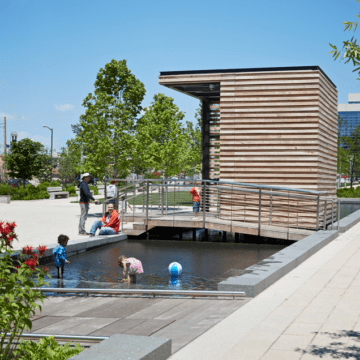
Amenities in the Ecological Core are also designed with potential flooding in mind. Asphalt trails, which tend to deteriorate with prolonged water exposure, will be replaced with wooden boardwalks. Picnic areas will be elevated to ensure their continued use; an important consideration in Philadelphia’s most popular picnic site.
“The park needs to be flexible to a rate of climate change that we can’t predict anymore. We can’t engineer out of this situation, but we can adapt.” – Charles Neer (WRT)
The Urban Edge encircles the park, providing an attractive and welcoming interface with the community. “The park itself is a place of climate refuge [from extreme heat],” says Alison Schapker, director of capital projects at the Fairmount Park Conservancy, and the Urban Edge welcomes visitors with abundant shade and a network of green stormwater infrastructure, designed to manage runoff from the surrounding urban areas. Twenty acres of the park will be reforested with species like sweetgum that are expected to thrive in a hotter, wetter future. The master plan team also worked with Philadelphia’s Office of Sustainability, Water Department, and Floodplain Manager to analyze impacts of climate change, flooding and sea level rise.
Stormwater management interventions within the park are designed to exceed PWD stormwater management goals by managing surface runoff from outside park boundaries. Green stormwater infrastructure is proposed near the northern and southern borders of the site to manage water coming from surrounding roads. This is especially important near Interstate 95, where 15 acres of untreated highway run off onto the park, creating significant maintenance issues within the park. Natural filtration systems ensure that the park can accept stormwater from the roadways without degrading water quality in the Park’s lakes or impacting park infrastructure
The City’s Green Plan, a long-term vision for the citywide open spaces, suggests the creation of green streets surrounding the park that act as neighborhood cooling corridors and comfortable park access routes. Although FDR is the only large park in Philadelphia that is directly connected to a subway station, most visitors arrive by car. The master plan aims to make FDR park a destination for walkers and bikers, both by improving trail systems within the park and by creating more welcoming entrances for alternative transportation.
The Urban Edge will also be home to the park’s recreational amenities, including athletic fields, playgrounds, pavilions, and comfort facilities. Some of these amenities will be elevated to ensure their continued use during flooding conditions.
The master plan anticipates the projected impacts of climate change and envisions a park that not only retains its recreational value in a hotter, wetter future, but also actively mitigates the impacts of higher temperatures and more frequent flooding. The park’s mitigative capacity extends beyond its borders, providing essential services to the surrounding area.
Value Creation
FDR park can only provide environmental, recreational, and economic benefits to the community if it is adequately funded and maintained. Concurrent to the development of the master plan, the team worked with the City and recreational consultant Greenplay to develop an operations and maintenance plan and operating proforma for FDR Park. As a result, the master plan reflects the importance of creating a self-funding park that balances opportunities for revenue generation with access and equity. If successful, FDR Park will be the first self-sustaining park in the city, generating enough funds to cover its operations, maintenance, and staffing costs.
According to Schapker, “Many of the things people the community are asking for will generate revenue for the city,” including bike and boat rentals, trails, athletic fields (which generate tournament fees), and food vendors. The 15-acre Great Lawn may host events while the multi-use trail also doubles as a 5k course. The master plan also anticipates ways that the park could capitalize on its proximity to three of Philadelphia’s major sports venues: the Wells Fargo Center, Lincoln Financial Field, and Citizens Bank Park by offering parking and dining opportunities for fans.
Maintaining consistent staffing is also integral to the overall resilience of the park. As Neer explains, “When the park has dedicated staff, they will be more aware of the environmental situation. What’s working? What’s not? They will be able to calibrate and schedule use of the park accordingly.” With a consistent revenue sources, the master plan hopes to make dedicated staffing possible.
Next Steps
The first phase of implementation will include the creation of almost 40 acres of wetland on the park’s southwestern side, completed in partnership with the Philadelphia International Airport. With the creation of a mitigation wetland in FDR Park, the Airport will be able to pursue its own development projects while also improving the hydrologic function of FDR Park and providing fill to elevate new amenities out of the floodplain.
As of July 2019, funding remains to be secured for the remainder of the master plan. The project team anticipates it will be funded with a mix of local, state, and federal funds as well as private corporate and philanthropic partnerships.
“FDR Park is an example of a public/private partnership; an example of civic investment; and an example of climate resilience. The opportunities in all of those areas work together rather than against each other.” – Allison Schapker (Fairmount Park Conservancy)
Although it may be years before this new vision for FDR Park is fully realized, the master planning process provides an exciting path forward for the creation of a park that is vibrant, self-sustaining, and resilient, that can serve as a blueprint for park development in Philadelphia and beyond.
Sources
- Climate projections: https://www.phila.gov/media/20160504162056/Growing-Stronger-Toward-a-Climate-Ready-Philadelphia.pdf
- Interviews with Charles Neer and Mary Morton (WRT, LLC) and Allison Schapker (Fairmount Park Conservancy)