Steve Hennigan, president and chief executive officer of Credit Human, said he adopted a “different perspective and paradigm” in planning the building to challenge engineers and others involved in constructing the project. Hennigan urged those assembling the project to base their work not on current best practices but on what was “theoretically possible.” As such, his stance was this: “Give me a reason why it can’t be done.” Credit Human partnered with Silver Ventures to co-develop the building complex, which also includes the Oxbow and a parking garage.
Credit Human Federal Credit Union’s headquarters at 1703 Broadway in San Antonio sets a new standard for sustainable commercial buildings in Texas. (Credit Human)
Taking a long-term view of the building has also allowed Credit Human to break through conventions and see the long-term payoff for investing in sustainable building technologies, with Hennigan noting that Credit Human occupied its previous headquarters for more than 40 years. “We have a history of buying and holding things,” he said.
Climate Resilience Strategies
Water harvesting and recycling
A combination of rainwater and condensate capture, storage, and reuse systems make the project one
of the most water-conscious developments in Texas. “There is really almost nowhere on this building
where we’re not capturing rainwater,” says Matt Dunn of Joeris General Contracting, the general contractor on the project. The proprietary solar array and gutter system is designed to soak up the sun’s energy while allowing rainwater capture.
Several of the water storage tanks, including a 38,000-gallon tank repurposed from a local brewery, are
visible on the exterior of the building. It was important that the water conservation technologies were integrated with the building design to showcase Credit Human’s commitment to sustainability and conservation. Between the various water storage tanks, the building can store nearly 140,000 gallons of rainwater and condensate from its air-conditioning system to be used for irrigation, flushing toilets, and cooling the building.
A combination of rainwater capture, storage, and reuse systems make the Credit Human headquarters one of the most water-conscious developments in Texas. (Credit Human)
Beyond rainwater capture, the building’s geothermal heating and cooling system reduces water demand by diminishing the building’s dependence on cooling towers. With fewer cooling towers, the building requires about 1 million fewer gallons of chilled water to air-condition the building during the summer months.
In total, the water management systems have allowed the building to cut its demand for potable water from the San Antonio Water System by about 97 percent.
Energy efficiency
In looking at the building through a long-term lens, it was important that the design approach addressed the demand for resources before examining the supply side. Sticking with that policy, Credit Human initially weighed elements affecting the performance of the building envelope—elements, he said, that have been “quantum in their payoff.” The building walls feature four inches of continuous insulation and a thermally broken window system, a type of window construction in which a barrier between the inner and outer window frames limits the heat transfer through the window. The wall system doubles the insulation required by a Texas code baseline, allowing the building to reduce energy and water use, as well as operating costs involved with heating and cooling the building.
The payoff has been significant: the building uses approximately 96 percent less energy from CPS Energy, the municipal utility company, because of a 56 percent reduction in overall energy demand, as well as the building’s ability to generate its own energy through a rooftop solar array.
Business Outcomes
Reduced operating costs and water/energy savings
For Credit Human, the investments made in sustainable building systems have resulted in significant utility savings. Electricity and water at Credit Human’s two prior buildings—155,000 square feet combined—cost about $44,000 a month. At the new building, which is 200,000 square feet, the monthly cost is about $8,600. Credit Human estimates that the systems will result in a positive return on investment in 13 years or sooner.
Awards and recognition
The new headquarters has received significant attention for its sustainable design, including several awards:
2021 Associated General Contractors Outstanding Construction Award – Local Level
2021 San Antonio Business Journal Building San Antonio Award – Best Green Project
2021 San Antonio Business Journal Building San Antonio Award – Best Office Development, Large
The Indianapolis Cultural Trail: A Legacy of Gene and Marilyn Glick, a linear park and greenway, began as the brainchild of Brian Payne, president and CEO of the Central Indiana Community Foundation (CICF), who began advocating for the idea in 2000 and saw it through to completion in 2012. The Trail is now operated and managed by a nonprofit named for the greenway, The Indianapolis Cultural Trail.
An eight-mile loop of combined bicycle and pedestrian lanes surrounded by vegetation, with two more miles in development, the Trail connects five main historic or cultural neighborhoods to every significant arts, cultural, heritage, sports, and entertainment venue downtown and to the city’s already-successful greenway and bike system, which had previously not included any on-street bicycle facilities.
As described in a case study by the Pedestrian and Bicycle Information Center and Context Sensitive Solutions, the trail was conceived as a means of economic development and cultural placemaking. The Trail also became an intensive infrastructure upgrade project, which not only built bicycling and walking lanes for access and mobility and added art installations, but also replaced outdated sewers, roadways, and utilities.
As such, the project required millions of dollars in funding, which the city did not have in its budget. Nevertheless, through tireless community engagement and stakeholder meetings with key players, Payne and other supporters were able to secure nearly $30 million in private philanthropy, nearly half of which came from a major donation by Gene and Marilyn Glick, for whom the Trail is now named.
As a major transportation program, several federal grants were also secured, such as the Transportation Investment Generating Economic Recovery (TIGER) grant, to cover $35.5 million in remaining project costs, demonstrating the value of stacking public and private dollars for infrastructure projects with major physical and social benefits to urban development.
The Trail also provides major health and livability benefits by reducing the width of Indianapolis’s car-oriented broad streets, which had allowed cars to speed through downtown, impacting public safety, walkability, and air quality. By borrowing four to 12 feet of lane width in travel and parking lanes and expanding corner bump-outs at every possible location, the Trail significantly improves safety and multimodal transit for all users. Features such as ramps, countdown timers, and audible signals at traffic lights also ensure the entire trail network is universally accessible. A bikeshare program with discounted membership for low-income residents also expands access and supports equitable use of the trail, while supporting low-carbon transportation.
Construction unfolded in seven phases over six years, slowly expanding through Indianapolis. Community engagement was essential along the way—project teams engaged hundreds of residents through public meetings and door-to-door outreach, explaining each phase of the project as it went through a new stretch of the city and gathering input on design. The design team held a four-day charrette for stakeholders from city agencies, elected officials, state Department of Transportation and federal Highway Administration staff, and movers and shakers in local philanthropy, business, and neighborhood groups to build consensus and support and inform the design.
Public art also infuses the Trail, with a call for artists to contribute to the project and installations selected by an advisory committee. Similarly, green infrastructure accompanies the Trail at every turn in the form of an extensive network of bioswales, planted with drought-resistant native plants and trees, that absorb stormwater while enhancing biodiversity and beautifying downtown.
The Trail was ambitious in its multiple goals, as put by Rundell Ernstberger Associates, landscape architects and urban designers on the project:
“This project presented a once-in-a-lifetime opportunity to rethink the city on a variety of levels: reclaim public space once dedicated to vehicles for the exclusive use of pedestrians and bicyclists; provide a universally accessible, safe, and convenient transportation option for everyone from 8 to 80; create a significant and lasting contribution to the natural and built environment with a connective linear park that provides access to beauty and nature every day for everyone; pioneer new stormwater management techniques that minimize the impact to waterways; catalyze smart growth revitalization and economic investment that transforms underutilized properties into mixed-use, mixed-income developments; and achieve greatly enhanced mobility through transit integration and community bike sharing.”
The result was a compelling blend of mobility infrastructure, public realm improvements, and climate resilience features, all of which have contributed to a boom in redevelopment in downtown, where small businesses, shops, restaurants, and real estate development have filled in vacant and underused lots and supported a thriving economy, all protected from increasingly heavy rain and pollutant runoff by the Trail’s impressive bioswales.
Climate Resilience Strategies
As Kären Haley, executive director of the Cultural Trail organization, describes, development of the Trail in and of itself was a major resilience and sustainability strategy to enhance residents’ ability to move around and access their own city. “Investing in this level of pedestrian, bicycle, and people infrastructure is a huge part of the resilience effect of the trail, especially in a city in Midwestern America, where for the most part, people get around by cars.”
An expansion that opened in mid-summer 2024 will expand that impact further. “The city and private philanthropic partners have announced a $50 million investment in building out the rest of the city’s trail and greenway network. That will bring the benefits of walkability out into neighborhoods that generally are not connected to the downtown or to each other by means other than roads.”
Parks and open spaces
The Trail added a total of five acres of linear green space to downtown, which was previously impervious surfaces. These park areas are not only an opportunity to integrate green infrastructure, but also for health and wellbeing as an active recreational resource and placemaking strategy. “The green infrastructure solutions are adding beauty to downtown,” says Haley. “Right now, for example, we have red cardinal flowers growing in most of our stormwater planters. It’s not just that the Trail provides economic benefit for people, and not just environmental benefit, but it makes it a beautiful place to be. And so if you’re able to build that in your community or town or your private development, your employees, your residents, your clients, they’re going to have that same beautiful experience when they walk into your building or they walk onto the property.”
Bioretention swales and rain gardens
The Trail’s stormwater protection features center on the 25,000 square feet of bioswales lining the walking and biking lanes. The swales are sunken in some cases up to two feet deep to maximize stormwater capture capacity, and measure five feet to nine feet wide and anywhere from 12 feet long to the length of an entire city block.
This district-scale system minimized the need for new sewer infrastructure, as it gathers up to four million gallons of rainwater per year. This water then infiltrates into the ground through a natural, unsealed bottom, made possible by the naturally occurring, well-drained, sandy soils, helping recharge local aquifers after cleansing runoff of pollutants. The use of green infrastructure saved the city significant costs in sewage treatment, helping the business case for investing in the system.
It also helps boost the health of local waterways by limiting the occurrence of combined sewer overflows. This was a much-needed improvement after Indianapolis, like many U.S. cities, was placed under a consent decree from the EPA to improve its water quality.
An overflow system was built as a backup to help drain stormwater from an extreme rainfall into the city’s pipes, but in the 10-plus years since construction, Haley noted in a video interview that this added backup has not been needed even once.
As a result, the Trail’s stormwater management system has become what Haley calls “proof of concept” that green infrastructure, and its philosophy of handling water as a resource rather than a nuisance to be piped out as quickly as possible, is feasible at scale in a large city.
Native plants and trees
The planters are filled with thousands of perennial plants and hundreds of shrubs native to the Indianapolis area, which also support local pollinators and wildlife and boost biodiversity. Species were selected for their drought tolerance, meaning little to no extra irrigation or fertilizer is required, lowering chemical inputs and maintenance costs.
Hundreds of trees have also been planted along the Trail, which in addition to the plants and shrubs, contribute to reducing the urban heat island effect by providing shade and natural cooling.
Business Outcomes
Construction of the Trail had a transformative impact on downtown Indianapolis. The Trail is now known internationally as a model for redevelopment focused on multimodal transit and arts and culture, as well as sustainability. In addition to giving numerous tours of its stormwater management system, it has inspired use of similar green infrastructure techniques by other landowners with large properties, such as Butler University and local hospital systems, according to Haley.
Enhanced property value, business development, and capital attraction
Construction of the Trail raised nearby property values by $1 billion from 2008–2014, according to an analysis by the Indiana University Public Policy Institute. Businesses and organizations relocated to be closer to the Trail, and business owners hired additional staff, saw revenues increase, and lengthened their hours of operation in response. The Trail has attracted significant foot traffic, which is a major boost for retail and commercial uses in the area—that same analysis also estimated that, based on surveys of anticipated spending, use of any single segment of the Trail could generate roughly $1 million to $3 million of economic impact. With an initial cost of $63 million, every dollar spent on the Trail created roughly $16 dollars in value.
This is in large part, according to Haley, because of the green infrastructure added to the Trail. “People generally want to be in beautiful places, and they want to be surrounded by lush, vibrant greenery. . . . In terms of creating beauty and quality of place, you can do that with green infrastructure, and it just makes it a more desirable place to be. I think about a road in Indianapolis where the Cultural Trail is, and a road where the Trail isn’t, and the people are on the roads where the Trail is. They’re stopping in those retail locations. They are waving at each other as they walk by. They’re walking into their places of business or their schools. And you just don’t have that foot traffic on those opposite streets that don’t have the Trail. It brings the people, and that investment in nature and beauty is good for everybody.”
Awards and recognition
The Cultural Trail has shone a spotlight on Indianapolis as a leading city with bold vision, and brought numerous awards including the International Downtown Association’s 2013 Downtown Pinnacle Award: Public Space and the Indianapolis Chamber of Commerce’s Monumental Award. The Trail was also included in the New York Times’ list of 52 Places to Go in 2014. The Project for Public Spaces, which supported research and conceptualization of the Trail, noted that “Today, the Cultural Trail has become a global model of how cities can magnify the impact of their public spaces and cultural assets by focusing on the journey and the destination when connecting people to the places they love most.”
Added amenity
The Trail adds significant walking and biking access to the city of Indianapolis, as well as green space, creating opportunities for building health and wellness while accessing the best of the city’s entertainment and cultural venues.
Avoided losses
The stormwater bioswales reduce risk of flooding in downtown by absorbing excess rainwater that may otherwise damage buildings and infrastructure. As the Midwest is projected to see an increase in heavy downpours due to climate change, the ability to manage this stormwater safely is critical.
Lessons Learned
Champions are important: Brian Payne was instrumental in leading the charge on creation of the Trail, and sought donors tirelessly until private philanthropy could pick up half the final bill. Major city-reshaping projects for resilience and urban development benefit from having an advocate who can successfully communicate a big vision.
Collaboration and partnership are key for major projects: The Trail’s development underscores the importance of collaboration between public and private sectors. Pooling resources, gaining public support, and bringing in diverse stakeholders to inform the project were crucial for its success. This lesson highlights the value of fostering strong partnerships to achieve complex urban development goals. Haley notes that partnership is especially important with whichever stakeholder oversees stormwater, whether a utility or municipality to ensure they’re on board with a potentially new or different approach.
Inclusive design and community engagement build support: The Trail’s design process involved extensive community input, ensuring it met the needs of all residents and responded to their feedback when a design change was necessary. Engaging communities early and continuously in the planning process can create spaces that are widely accepted and used, enhancing the project’s long-term success.
Leverage existing spacefor multiple goals: The Trail was a thoughtful solution to Indianapolis’s challenges with excessively wide streets and autocentric design. By repurposing lanes and lane widths not needed for a more multimodal city, the Trail was able to cost-effectively use existing infrastructure to adapt itself to updated ideals for urban design, serving more users, supporting health and wellness, enhancing downtown, and building resilience to heavy rainfall all at once.
When the opening of the Denver International Airport meant the closing of the Stapleton International Airport in the mid-1990s, a coalition of business and philanthropic leaders in the city realized the unprecedented opportunity to guide the former airfield into an environmentally and socially rich “city within a city,” that could continue the legacy of Denver’s historic neighborhoods while creating an abundance of new housing built around a system of parks.
Caption: Central Park’s redevelopment features large open spaces that help restore Colorado’s high prairie ecosystem with native and naturalized plantings.
Jim Chrisman, former senior vice president with Forest City Stapleton and then Brookfield Properties, and now an independent consultant, worked on the project for 30 years and saw it transform from the “Stapleton redevelopment” into the Central Park neighborhood of today. Chrisman notes how the coalition of local civic leaders raised several million dollars to fund creation of a master plan known as the Green Book. The plan was completed in the early 1990s in anticipation of the airport closure in 1995. This plan, ahead of its time as the concept of “sustainable development” was still in its infancy, laid the foundation for and defined the ethos for the project. It also underpinned selection of family-owned company Forest City as master developers for the project in 1998, as recounted by Bill Vitek. Vitek is principal with landscape architecture firm Dig Studio, which has worked on the community’s design guidelines and a large portion of Central Park’s 1,116 acres of parks and open space.
The development’s style, master-planned by sustainability-minded firms HDR and Calthorpe & Associates, leaned more toward a “traditional, New Urbanist design concept where we had a much finer grain of housing types per block and per lot, and not the 40-acre superblocks that you see in the suburban projects” that were more popular at the time, notes Chrisman.
As Chrisman describes, “We pushed the envelope on having alley-loaded product. We went back to the old traditions of Denver, and no one was really doing that, but it really helps with the streetscape. We also pushed really hard on narrow streets.” These small design choices had a major impact on creating a pedestrian-focused public realm.
In addition to the urban design, parks were always central to this style of development. “Nearly 24 percent of the site is parks or open space,” says Vitek. “And the idea was always that if you had such a large percentage of the site being open space, you could do much smaller lots. You didn’t do one-acre lots, or half-acre lots. Even a quarter-acre lot is big out there. The overall premise was to use the community parks and open space as everyone’s backyard.”
Keeping the parks accessible was also embedded in other ways, as the parks are at the front of homes, with a public street in between. “Another decision we made was that no property would back up to the open space. There would always be public right-of-way between open space and houses, so all homes would front open space and everyone would have access to it, which is the exact opposite of the suburban model,” says Chrisman.
Finally, in equal importance to creating a nature-first community was making sure Denverites of many socioeconomic backgrounds could afford to live there. Far from creating a luxury gated community, affordable housing was a key goal from the start: “We [the Stapleton Development Corporation] wanted [affordable housing] integrated throughout the community. . . . We tried to locate it near transit and close to amenities, at modest scale and densities so it wouldn’t be just a big standalone project, and it worked very well,” says Chrisman.
To accomplish this, the master plan called for a diverse mix of housing types, from single-family to townhomes to apartment complexes, and the development also made sure to expand options in other ways: “Our product segmentation was very broad,” Chrisman explains. “We pushed for product diversity from the cheapest builders could build to the highest the market would support. We had a lot of ability for moving up and down.” Partnerships with nonprofit (and later for-profit) developers helped make this happen, as did initial donations of land and $30,000–$40,000 per home to ensure the income-restricted for-sale and for-rent units penciled out. Even today, there are income-restricted units for sale in the $200,000 range—a remarkable achievement in today’s urban housing crisis.
Amidst the impressive development of 12,000 homes and 5,000 apartments, 3.3 million square feet of existing flex/industrial space and 2.6 million square feet of retail, the themes of sustainability and climate resilience remain prominent. Landscape architects Dig Studio developed a network of open space and green infrastructure that prioritized use of native and naturalized plants, restoration of the Colorado prairie ecosystem, and natural management and conservation of water to create a more drought-, heat-, and flood-resistant community that supports wildlife and ecology, while providing a rich set of amenities for recreation, social gathering, and healthy living.
Climate Resilience Strategies
Green infrastructure and flood control
The open spaces at Central Park increased the park system of Denver by an impressive 25 percent. As Laurel Raines, founding principal at Dig, describes it, Central Park’s green space is “a system of parks. And what is really effective about this system is that there’s the layer of the parkways . . . [that] are extensions of Denver’s historic parkway system,” says Raines. “The parkway systems knit the new development back into the existing fabric of Denver.” But that’s not all, as there are also large regional parks like Central Park, which is what gives the redevelopment its name and forms the system’s center at 80 acres. “It’s a very large park. Then there’s all the trunk [or core] open space system, which is run by Denver Parks. The trunk open space system acts as a contiguous fabric through the entire development, and it is primarily a natural system.” Finally, there’s the system neighborhood parks, or pocket parks, which reach as small as half an acre and are meant to give each neighborhood its identity, relates Raines.
Caption: In addition to large core, or “trunk” spaces, the neighborhood features many linear parkways that extend out into the neighborhoods, expanding access to parks while creating biodiversity corridors. Homes front directly onto these parks but do not restrict public access.
This is the heart of Central Park’s resilience strategy, notes Vitek. “Twenty-five years ago we didn’t call it green infrastructure, but it really was serving the same functions. And I think that’s what’s key in any parks and open space planning today is that it has to serve multiple purposes. It has to serve stormwater management and water quality, recreation, ability for greater mobility, and habitat creation.”
In addition to the broad restoration goals, Central Park also naturalized systems for water treatment, quality, and flood control. The south side of the site was in a floodplain, and occasionally airport runways used to flood, so the entire floodplain needed opening up and redesigning. “The first major large open space, Westerly Creek, was designed to take all the pipes that used to go under the ground for the airport and bring them through in a natural waterway through the center of the park and act as a flood control as well as water quality measure. And within the first year or two, the entire calculated drainage area filled up. It was like a lake. It certainly proved the point that it was needed and served its function,” says Vitek.
Caption: This network of large parks, parkways, and neighborhood “pocket parks” offers multiple opportunities to capture and retain stormwater, reducing flood risk and helping recharge groundwater supplies.
Additionally, Chrisman describes how the development team decided to work on a larger scale of water quality management. “We also made a decision that we were going to have regional water quality measures. What you typically see is someone buys five acres and they would have their own small detention pond, and [others do the same] and you have a whole bunch of properties with little detention ponds and it doesn’t look good and I don’t think it’s efficient from a water quality standpoint. We regionalized all that and had regional detention ponds that all properties would flow into.”
When major, hundred-year storms hit Denver in 2013—in Chrisman’s words, “just ridiculous amounts of rain”—the system was tested and passed with flying colors. “That Westerly Creek corridor was able to manage it. There are photos of the water almost up to the bridge, but it managed the water successfully.”
Native plants
The natural landscapes of the Central Park natural system were primarily designed as a restoration of Colorado’s historic ecosystem. Vitek and Raines explain that design guidelines for common and private land prioritize the creation of “Colorado-scape,” an evolution of the idea of xeriscaping, which focuses on use of native and naturalized plants that are adapted to the arid climate and do not need extra irrigation, in place of imported eastern lawn grass species. These plant species also attract pollinators and support biodiversity, and studies show they help with the urban heat island effect, because their roots are so much deeper than lawn species that they help more water evaporate from the soil and cool the area. Finally, they do not spread weed seed into the National Wildlife Refuge, which is adjacent to the neighborhood.
Caption: Landscape design focused on plants suitable to Colorado’s ecosystem, which would support pollinators and the larger food chain while also helping reduce water use for irrigation and enhancing the parks’ ability to cool their surroundings.
This evolution, as Vitek describes, was a shift in philosophy from the City Beautiful movement that shaped Denver in its early days, based on eastern U.S. designers’ ideals of lush lawns, to what he calls the “City Ecological” ideal focused on the no-less-beautiful but more appropriate local aesthetic of Denver’s high prairie landscape. This focus has rewarded people and nature, providing what Vitek calls “an opportunity not only for connective recreation, but connective habitat,” as they even saw beavers move in shortly after the fences came down around the old airfield.
As Colorado has experienced greater challenges with water scarcity, the landscaping selections have become more water conscious. “The old guidelines from the south and the new guidelines from the north [of the development] are different. For instance, just the plant palette alone that is suggested is more water conserving than it used to be,” says Raines.
In addition, these native and naturalized plants also include tens of thousands of trees (nearly 40,000 officially, and Vitek and Raines suspect it may be closer to 50,000) that also help cool the area, support biodiversity, and enhance human mental wellness through their biophilic benefits.
Reclaimed water
Lastly, the area uses Denver’s reclaimed water system, also known as purple pipe water (sewer water that has gone through sufficient treatment for nonpotable reuse). This water now irrigates the larger parks in the system, significantly reducing water withdrawals for irrigation.
Energy efficient buildings
As a key aspect of sustainability, many buildings in Central Park have been designed to LEED standards or Energy Star requirements. By virtue of these achievements, Central Park has become the largest Energy Star community in the state.
Value Creation
Added amenity and enhanced user experience
The parks and open spaces create significant amenity value for Central Park as places for recreation, exercise, and connecting with nature, improving quality of life for residents and Denverites and attracting large numbers of users.
Avoided losses, energy savings, water savings, and reduced operational costs
The natural flood control and floodplain protection measures significantly reduce the potential for property damage from heavy storms and river flooding. Additionally, the high level of energy performance required for buildings and the drought-resistant plantings both reduce energy and water use and associated utility bills for residents and owners.
Awards and recognition and marketing advantage
As development has unfolded, Central Park has attracted numerous awards, including a 2006 ULI Award for Excellence, a U.S. EPA Environmental Achievement Award, and the prestigious Stockholm Partnerships for Sustainable Cities Award from the King of Sweden, among others. This recognition as an international model for large-scale, sustainable redevelopment creates significant competitive advantage and marketing opportunities.
Business developmentand enhanced property value
The high-quality design and execution of the homes and communities in Central Park have created high demand and a strong pool of occupants. From 2010–2019, Central Park appeared six times in RCLCO’s lists of the year’s top 10 best-selling master-planned communities in the United States. As Vitek notes, “study after study will show that communities that have more parks have a higher premium value for properties and sales. . . . Additionally, Central Park stood the test of time during the COVID-19 pandemic, because sales there continued, while in other places they really dropped off.”
Raines and Chrisman both highlight that resale within the neighborhood is one of the biggest sales pools, constituting 40–50 percent of sales every year and demonstrating a high level of satisfaction and desire to remain in the neighborhood. As Raines puts it, “This is a beloved neighborhood. It’s very common for people to move from one house to another, to another.”
Although in a large, master-planned community it can be hard to attribute success to a single factor such as parks, Chrisman believes it has much to do with the exceptional amount of green space created. Though he notes the location was hampered by an Air Force base to the south, an Army medical hospital to the east, and an Environmental Protection Agency Superfund site to the north, the parks were able to overcome those barriers. “They really did create value in the long run, especially with the way we had the houses fronting the parks. It created immediate value for their homes as well as overall value, because it created demand for people to want to be there. And there’s no way to prove it, but if we’d had only 400 or 500 acres of parks [instead of the 1,100], I don’t think it would have done as well.”
Lessons Learned
Embed sustainability from the beginning. Central Park’s champions, the group of leaders in the Stapleton Redevelopment Foundation who began the master-planning and development process, were committed to environmental and social performance from the start and ensured the execution matched the original vision of the Green Book. Sustainability is best achieved when it informs every choice made throughout a development’s life cycle.
Find the right partners. Similarly, sustainability can be difficult to carry out unless all partners throughout the value chain are committed. The Foundation was able to find the right development partners, from Forest City and Brookfield to design consultants Dig Studio, HDR, Civitas, and Calthorpe & Associates, to the multiple builders involved, to align on aiming high for the redevelopment.
Design for the long term, even if ahead of one’s time. Sustainability is still not mainstream in real estate, but when the redevelopment planning began in the early 1990s, sustainability was far from reaching the levels of acceptance it has today. Nevertheless, the development team realized its potential as a strategy to create lasting value, and as modern demand for ecologically and socially oriented communities continues to rise, the development is well-positioned to capture even greater value.
The Aurora Bridge is an essential piece of Seattle’s transportation infrastructure and carries more than 65,000 vehicles through the city per day. During the city’s frequent rainstorms, chemicals from the roadway are cast into the waters of the Lake Washington Ship Canal below. This untreated runoff—which researchers say is six times more toxic than the national standard—flows directly into local waterways, harming the health of local ecosystems, economies, and communities.
As climate change increases the severity of Seattle’s rainstorms, the volume of stormwater runoff is expected to grow. According to research commissioned by Seattle Public Utilities (SPU), extreme rainstorms have become 30 percent stronger since 2003 and are projected to intensify over the coming decades. Heavy rainstorms are already overwhelming the sewer system’s capacity in many neighborhoods, triggering flooding and toxic overflow into local waters.
Developers Mark Grey, Joanna Callahan, and Mike Hess of Hess Callahan Grey Group (HCG) were inspired to do their part after learning how polluted stormwater affects local wildlife. They had watched a video of baby salmon dying when put directly into water runoff from a nearby bridge. The video then showed the runoff being filtered through soil before introducing the fish, resulting in none of the fish dying. The video demonstrated the power of natural systems to mitigate the effects of toxic stormwater.
This knowledge led HCG to partner with Salmon Safe, a local organization working to protect waterways, to integrate green infrastructure into two commercial office projects they were developing on a steep slope under Aurora Bridge. Given the unique location, the project team saw an opportunity to collect and treat the bridge’s runoff while improving the adjacent rights-of-way along Troll Avenue, directly underneath the bridge. Dark and unwelcoming, these overlooked tracts of land were mostly empty except for the streams of polluted water that were spilling out of downspouts from the bridge above.
The team installed the bioswales in three phases. The first two phases, which line Troll Avenue, were financed and permitted as part of the two office projects’ frontage improvements. The third phase, which sits down the hill and closer to the lake, was developed thanks to a nonprofit, Clean Lake Union, formed by Mark to advocate for continued clean-up efforts around the lake. Many public and private partners also contributed to the third phase, including Salmon Safe, The Nature Conservancy, Boeing, Tableau, Adobe, Seattle Public Utilities, and the state of Washington. Together, these three phases collect and treat up to two million gallons of water annually from the entire north span of the Aurora Bridge, minimizing the risk of neighborhood flooding and improving water quality.
HCG worked with project architect Weber Thompson and engineering firms KPFF and DCI Engineers to bring the swales to life. “The most exciting thing about this project,” says Rachael Meyer, landscape architecture principal and director of sustainability at Weber Thompson, “is that it has convinced so many people that green infrastructure is a viable solution, and it has paved the way for future projects of this kind to be developed throughout the region.”
Climate Resilience and Sustainability Strategies
Bioswales and natural stormwater management
The bioswales harness the power of nature to help collect, filter, and absorb stormwater before it is discharged into the lake. Six downspouts located under the Aurora Bridge carry runoff from the roadway into planted areas. The runoff flows through the swales before being returned to the municipal storm drainage system that discharges into Lake Union.
The swales in the first two phases, located on either side of Troll Avenue North, are terraced and step down every two feet of grade. At each stage, low dams made of Corten steel hold and slow the movement of water so that sediment and contaminants can be filtered into the soil, while the clean surface water outfalls to the next retention cell. The second phase also features staggered concrete walls, which help slow runoff from the adjacent building and promote evaporation. A block downhill, phase 3 is characterized by a spillway and five low steel walls to settle and divert incoming water before it reaches the lake.
Testing of the water entering and leaving the swales confirmed measurable filtration of a large range of contaminants.
The design incorporates consecutive swales down the steep hillside of Troll Avenue. As water flows through the swales, sediment in the runoff settles into the soil and the cleaned water at the top of the pool flows to the next stage. Image credit: Built Work Photography
Native Plants and Biodiversity
All three phases incorporate a variety of native plants and trees that provide both an aesthetic landscape and play an important role in stormwater management. Vegetation slows down the movement of water and filters sediment and other large particles. Plants also support healthy soils, which contain microbes that digest contaminants and other tiny particles.
The project team prioritized pollinator habitat by including flowering plants and designing flat areas within the swales where bees can find water and shady respite in the summer months. Native vine maples, which are often found in the understory of Pacific Northwest forests, add shade in the summer months and color in the fall.
Most critically, water that has made its way through the swales is visibly cleaner, promoting the health and longevity of five different species of migrating salmon that travel through Lake Union on their way to rivers and streams for spawning. Salmon are foundational to the region’s natural environment, fishing industry, and the cultural identity of local Native American tribes. As indicator species, they provide a signal of the overall health of the Pacific Northwest marine environment.
Native shrubs and Vine Maples serve as understory plantings to provide a robust forest floor below the overhead canopy that the bridge structure and columns simulate. Image credit: Built Work Photography
Green space and public access
Through the addition of native plants and natural features, the swales have enhanced two rights-of-way on Troll Avenue North as well as a previously grass-covered tract of land closer to Lake Union. Prior to the swales’ development, these areas were dark and forgotten, always in the shadow of Aurora Bridge above. Today, the swales open up the streetscape and provide a new place for the community to congregate in formerly degraded areas.
Educational signage in the first two phases engages visitors with the story of the swales and the importance of water quality on the region’s salmon species. Phase 1 also has embedded brass numbers in the sidewalk that show visitors the volume of water cleaned annually in the adjacent swale cell. The steel weirs in the third phase feature silhouette cutouts of the five species of salmon that reside in the nearby waterways.
The swales are centrally located in the heart of the Fremont neighborhood, known for its quirky shops, unique restaurants, and the iconic Fremont Troll, an 18-foot cement art piece that has lived under the Aurora Bridge since the early 1990s. Down the hill, next to the phase 3 swale, is the Burke-Gilman Trail, which serves more than one million pedestrians and bicyclists annually. Throughout the year, thousands of people travel beside the swales on the Burke-Gilman, on the way up to the Troll, or down to the waters of Lake Union.
Value Proposition
Added amenity
The bioswales transform previously dark, vacant areas into well-lit, landscaped destinations that people are eager to visit and enjoy. Lined with native plants, the meandering pathways, plazas, and benches invite visitors to gather, take photos, and spend time observing the natural flow of water through the swales. “People stop and appreciate the bioswales even without really knowing what the system is doing to protect the neighborhood and improve water quality,” said Meyer.
Reduced maintenance costs
Prior to the swales, the area that is now phase 3 was covered in grass, requiring regular mowing and upkeep. Today, minimal maintenance is needed beyond an occasional weeding. In addition, nearby property owners have reported reduced instances of vandalism since the swales were installed, reducing the need for frequent repairs and upkeep.
Awards and recognition
The bioswales have been recognized by numerous organizations for their unique design and success delivering environmental benefit through a unique public/private partnership.
ULI Global Award for Excellence Winner, 2023
ULI Americas Award for Excellence Winner, 2023
2022 GRAY Magazine Awards, Grand Winner: Landscape Design
2022 Gold Nugget Awards, Merit Award: Best Landscape Architecture for a Community
2022 WASLA Awards, Honor Awards: General Design, Private Ownership
2019 King County Green Globe Award: Leader in Water Quality Solutions
2018 WASLA Awards, Phase 1: Vision Award for Water
A case study of this project is included in a United Nations Guide for Sustainable Practices to teach professional designers ways to include green infrastructure as a standard practice.
Staggered concrete walls help slow runoff and promote evaporation, reducing the amount of water flowing into the swale. Image credit: Built Work Photography
Lessons Learned
This project demonstrates how privately funded green infrastructure can be leveraged to improve public roadways, especially bridges, and provide community benefit. Prior to the Aurora Bridge swales, few precedents existed for private developments electing to clean roadway runoff as part of frontage improvements. This type of development was not originally allowed outright in the city’s code but has now paved the way for more streamlined permitting of future swales across the city. In addition, the success of the Aurora Bridge swales has inspired Seattle Public Utilities to establish programs to incentivize similar improvements as partnerships with private developments.
The project team has observed that the bioswales are dry most of the time, indicating that less space is needed to collect and filter the bridge’s runoff. This means that the system’s capacity can keep pace as Seattle’s rainstorms become heavier and more severe. Climate predictions for the Seattle area indicate that extreme precipitation events are likely to be more intense. For example, the magnitude of the average 25-year storm is expected to increase by 13 percent by 2050 and 12 percent by 2090.
The bioswales offer a replicable model for other communities looking to leverage green infrastructure to improve stormwater management and water quality in urban settings. The regulatory environment around stormwater management is complex, and the team had to navigate numerous requirements from various public agencies at the city, state, and federal level. In particular, the project had to secure special approval to divert roadway catch basins and downspouts into the right–of–way temporarily before returning the water to the storm drain system. Despite these hurdles, the success of the bioswales demonstrate the importance of collaboration among these agencies to realize significant community and environmental benefit.
Thank you to Alex Wilson and the Resilient Design Institute (RDI) for permitting a reprint of the article “Babcock Ranch – A Solar Town Proves Resilient During Hurricane Ian,” which was incorporated as the Context and Climate Resilience Strategies sections of this project profile.
Context
Babcock Ranch was a 91,000-acre (143 sq mi) property in southwest Florida when it was acquired by Kitson & Partners in a complex real estate transaction in which 80 percent of the land was immediately sold to the state of Florida. The property is named after Edward Vose Babcock, a past mayor of Pittsburgh, Pennsylvania, who purchased the land in 1914.
The private development company, Kitson & Partners, founded by the former professional football player Syd Kitson, stepped in and purchased the entire property in 2006, then immediately sold roughly 73,000 acres of the land to the state, with some of the funding from Lee County, to create the Babcock Ranch Preserve, which continues ranching operations that support the maintenance costs of the preserve. The remainder of the land is being developed in an environmentally responsible manner.
“Developers have an impact on the environment, and we need to mitigate those impacts,” Kitson told RDI. “What I set out to prove is that building a new town—a new city—can work hand-in-hand with the environment. I think we’re doing just that.”
Kitson & Partners, with input from public planning meetings held in 2006 as well as outside experts including the Rocky Mountain Institute, developed an environmentally sensitive master plan with a high-tech commercial center that would include an R&D hub for clean energy development, four villages and five hamlets that would ultimately comprise nearly 20,000 homes and 6 million square feet of commercial space—all powered by solar energy. Under the plan, roughly two-thirds of the remaining property would be permanently set aside as open space.
Approximately 2,000 dwelling units have now been completed at Babcock Ranch, with hundreds more under construction. Most are single-family homes, but some are attached villas, townhouses, condominiums, and apartments, according to Jennifer Languell, PhD, who has served as the green building and sustainable development adviser through her company Trifecta Construction.
Climate Resilience and Sustainability Strategies
Site design and wetland engineering
Several factors contributed to Babcock Ranch’s performance during Hurricane Ian. For starters, most of the land is about 30 feet above sea level—veritable highlands for South Florida!
As promised, nearly 12,000 acres of the 18,000 that Kitson & Partners retained has been permanently protected as wetlands, uplands, greenways, and preserves. “Our water management plan is one that uses the natural flow-ways within the community versus clearcutting and forcing the water to go where it doesn’t want to go,” Kitson explained. “We went back and looked at maps a hundred years old and found the natural flow-ways.”
Wetlands and lakes are integral components of the stormwater management system at Babcock Ranch. Photo: Kitson & Partners, courtesy of Alex Wilson/Resilient Design Institute and Lisa Hall.
The wetlands were designed to mimic natural flows and provide natural stormwater management, according to civil engineer Amy Wicks, P.E., the engineer of record for Babcock Ranch Community and vice president of Kimley-Horn, which provided surface water management design, master planning, landscape architecture, roadway design, water and wastewater engineering, and permitting services for Babcock Ranch.
“The water management system is a multifaceted design that utilizes a natural systems approach, coupled with redundancy to protect infrastructure,” noted Wicks. “While the system internal to Babcock Ranch starts with a series of rain gardens that ultimately lead to lakes for stormwater attenuation (detention), these systems then utilize a series of created wetlands and natural flow-ways for storage, similar to how natural wetlands act as storage during large storm events naturally.”
During extreme events, such as hurricanes, this distributed approach is highly advantageous, because it prevents blockages of culverts from causing flooding. “By having a system that operates both in series and in parallel, the system will flow a different direction with little effort,” she explained, “allowing it to function normally, even with blockages.”
Natural landscaping requirements
For a planned community in Florida, Babcock Range mandates native landscaping and minimal chemical treatments. “In common areas, Babcock requires 90 percent native vegetation, and for the homesites, 75 percent must be native,” said Languell.
A commercial center at Babcock Ranch with native landscaping that is resilient to storms. Most commercial buildings have solar modules on the roof. Photo: Kitson & Partners, courtesy of Alex Wilson/Resilient Design Institute and Lisa Hall.
“We require native plant materials here,” said Kitson. “We decided that we were going to go for something authentic. What did Florida look like 100 or 200 years ago? There’s a reason those native plant materials do very well in hurricanes and dry seasons and wet seasons—they’re accustomed to it.” Kitson, who doesn’t have any lawn area at his own Babcock Ranch home, described the native landscaping as beautiful. “I think if you drove through Babcock Ranch, you would notice almost immediately that this area is different.”
Yards at Babcock Ranch can only be 30 percent grass. Lawns are restricted, explained Kitson, because they don’t want the chemicals—including phosphates and nitrates—contaminating their surface waters. “Our lakes are crystal clear because of the limerock, and we don’t want to do anything that disrupts that,” he said. “There are no algae blooms here.”
High-performance, hardened buildings
All buildings at Babcock Ranch must be certified by the Florida Green Building Coalition’s Green Home or Commercial standards, which Languell described as similar to the U.S. Green Building Council’s Leadership in Energy and Environmental Design (LEED) rating, but specifically designed for hot-humid climates. She noted that this is “the only certification program that contains a disaster mitigation section.” Under the building code, “homes are required to be designed to 160-mph wind loads,” said Languell.
Buildings are designed to the Florida Green Building Coalition’s Green Home or Commercial standards, which can include wind-resistant concrete construction. Photo: Alex Wilson/Resilient Design Institute.
Hip roofs are used on most single-family homes to protect against high wind, because of the better performance in high wind than gable roofs. Hurricane strapping, continuous structural connections between foundation and roof framing, and other structural requirements are rigorous—as mandated by the Florida Building Code, which Kitson credits with dramatic improvements in how well newer homes perform throughout Florida. Homebuilders who build at Babcock Ranch also have to either install hurricane-rated windows or supply homeowners with removable hurricane shutters.
Buildings, mostly built of concrete masonry units, are heavily reinforced with rebar and concrete-filled cores for strength.
Many homes include strong metal roofs for wind and debris impacts, and pervious pavers for stormwater management. Photo: Alex Wilson/Resilient Design Institute.
The average Home Energy Rating Score (HERS) for homes at Babcock Ranch is 58—which Languell said is “25 percent more efficient than the Florida Energy Code, which is fairly stringent.” Electric heat pumps are used for all heating and cooling, though natural gas is used in some houses for cooking and water heating.
Both indoor and outdoor water conservation is a community focus, according to Languell. “All plumbing fixtures must be at a minimum WaterSense, but we find that most builders are doing better than the minimum WaterSense conservation levels.”
Site elevation and protection strategies
All homes at Babcock Ranch are built “1 foot above the flood elevation of a 25-year event followed by a 100-year event,” according to Wicks. This standard was adopted to address the increased flood vulnerability when soils are already saturated from prior precipitation, and it equates to about 11 inches of rain followed by 14 inches of rain (25 inches total), she told RDI.
There are no basements to flood, because all buildings are slab-on-grade (which is standard practice for much of Florida). Fill dirt from creating the lakes was used to elevate house sites on the building lots.
Specialized floodproofing measures, such as flood vents and use of wettable materials (materials that can get wet and dry out without growing mold), are not required at Babcock Ranch, according to Wicks, “because we do not anticipate any flooding events.” She explained that “because of the extra precautions taken in the design of the elevations and the stormwater management system, floodproofing of the buildings is not necessary.”
Resilience also involves protection from winds. “All utilities are underground,” said Kitson. The Babcock Ranch–owned water, wastewater, and reclaimed water pipes were colocated with conduit for electricity and data utilities. With all utilities buried, risk of damage from storms is all but eliminated.
A solar city
Babcock Ranch bills itself as “America’s first solar city.” As part of the development plan, Florida Power & Light (FPL) operates two solar farms that generate 150 megawatts on 840 acres of Babcock Ranch. The FPL arrays produce enough electricity to power 30,000 homes—more than will exist at Babcock Ranch at buildout. The rest of the power is fed into the FPL grid.
The two 75-megawatt solar fields at Babcock Ranch comprise over 700,000 modules spread over 840 acres and owned by Florida Power & Light. The field includes 10 megawatts of battery storage. Photo: Kitson & Partners, courtesy of Alex Wilson/Resilient Design Institute and Lisa Hall.
Kitson describes the relationship with FPL as extremely positive. Kitson & Partners gave FPL 440 acres for the first 75-megawatt solar plant, and the company purchased another 400 acres to build a second array. More than 700,000 solar panels have been installed on these 840 acres. In addition to the large, ground-mounted solar array, most of the commercial buildings have extensive solar arrays on their roofs.
A 10-megawatt battery system helps with power management, but this is really part of what Babcock Ranch refers to as their “Living Laboratory,” according to Languell, which will showcase new and emerging energy technologies. “As battery technology is changing rapidly, we continue to work with Florida Power and Light to research and potentially test next-generation systems,” she said.
Value Proposition
Avoided losses
Babcock Ranch performed remarkably well during Hurricane Ian. The community never lost power or water service, and in property damage, a few young trees were downed that were quickly righted and some roofs saw minor dislodging of tiles or shingles. According to Kitson, “other than that, if you drove through here a day later, you would not know that all around us . . . there was destruction or that a Category 4 hurricane basically sat over us for over eight hours.” Given that Ian was the costliest hurricane in the state’s history, emerging unharmed from it creates significant value in avoided losses for property owners.
Awards and recognition
Babcock Ranch received major national attention after its success during Hurricane Ian, being featured in multiple news outlets. The community has also received multiple awards for its design, including two Edison Awards for sustainability and resilience, and was listed as the fifth best-selling master-planned community in the United States in 2022 by RCLCO and John Burns Real Estate Consulting, up from 14th of 50 in 2021.
Extended building life
As buildings are built out of the floodplain, using durable materials resistant to wind, they should incur less damage and repair/replacement costs over their lifespan.
Energy savings
Babcock Ranch’s sizable renewable energy resources and energy efficient home designs create notable energy savings, which should translate to cost savings as well for residents.
Lessons Learned
Thinking community-wide creates greater opportunity. Babcock Ranch’s resilience to extreme weather is derived from the combination of its inland site selection, innovative stormwater management system, extensive backup power, native landscaping, and building hardening approaches, none of which would be as effective in isolation. Developments that can work at multiple scales will see better outcomes against multiple hazards.
Careful design attracts attention. A well-deserved reputation for resilience can be as important to a project’s success as its design features. Babcock Ranch’s rapid rise to prominence after weathering Hurricane Ian demonstrates that real estate developments prepared for extreme weather will stand out from the crowd and build significant market distinction.
Finding the right partners enables bold steps. A major aspect of Babcock Ranch’s ability to withstand disruption is the energy resilience provided by the network of on-site renewable energy and battery storage, enabled by the strong partnership with Florida Power & Light. Partnerships among real estate, utilities, and other energy providers can be critical to ensuring buildings and sites can stay operational during climate hazards.
Alys Beach began design in 2003 as a labor of love by EBSCO’s cofounder, Elton Bryson Stephens, Sr., who bought the land in the late 1970s and named the future community after his wife, Alys. The area, known locally as 30A after the scenic highway running through it, and its beach resort communities are a treasured destination across the Southeast, with increasing recognition in other regions. Most homes in Alys Beach started as vacation homes, but post-COVID, many homeowners took up year-round residence.
Alys Beach stands out for its award-winning New Urbanist design, created by some of the founders of New Urbanism itself—DPZ CoDesign, the firm established by Andres Duany and Elizabeth Plater-Zyberk, in collaboration with and carefully maintained by town architects Marieanne Khoury-Vogt and Erik Vogt, who have added their own flair and influences from Moorish, Greek, and other vernaculars.
As Galina Tachieva, managing partner at DPZ explains, Alys Beach was informed by the earlier, nearby DPZ projects of Seaside (already famous by the time) and Rosemary Beach, and can be understood as a third generation of sustainable and resilient developments that prioritize compact, walkable, pedestrian-scaled communities filled with open spaces and public gathering areas in the style of older, pre-automobile cities around the world. “The compactness of these communities is the number one condition for being environmentally responsible, because then you can leave nature alone,” she notes.
Storm resilience was also an obvious necessity, given the location and the community’s origins. “The Stephens family was committed to this as a legacy project and was not going to take shortcuts, and understood the need to invest on the front end,” according to Khoury-Vogt. Developer and designer visions aligned, and when DPZ was brought in, “it became really important that sustainability was considered on all aspects of the project from the horizontal infrastructure to the vertical infrastructure.”
As described by Allan Barnes, president of Apex Engineering Group, every structure is designed to withstand wind speeds over 160 miles per hour, or a Category 5 hurricane and an F3 tornado. Homes near the water are built to the ASCE/SEI Standard 24-14, Flood Resistant Design and Construction, and the guidelines of FEMA P-550, Recommended Residential Construction for Coastal Areas: Building on Strong and Safe Foundations, using deep pile foundations and site walls that can endure wave impacts, scour, and erosion. All told, the site is prepared to experience “extreme storm event-related erosion and scour” and “the dynamic wave set-up and surge elevation of a 100-year storm event.”
Climate Resilience and Sustainability Strategies
Alys Beach uses a combination of green infrastructure/site strategies and building strategies to achieve a resilient design that responds to its main risks of hurricane winds and extreme heat, and in extraordinary cases, storm surge.
Alys Beach is located roughly 30 feet above sea level behind preserved natural dunes, which protect the community from storm surge. The community continually replenishes the dunes to maintain them as an important coastal habitat and resilience measure. Courtesy of Alys Beach.
Grade elevation and access
“We’re lucky here that we have a natural elevation that’s about 30 feet above the water, so we’re relatively inoculated against floods,” says Khoury-Vogt.
Preserved natural features
The master plan preserved the site’s original coastal dunes as the first line of defense, as well as 20 acres of existing wetlands on the opposite, inland end. The community regularly replenishes these dunes to ensure they remain functional for aesthetics and protection.
Green infrastructure and landscape features, and natural drainage system
In addition to these preserved natural features, designed green infrastructure permeates the entire site. All pavement is permeable, and the underground stormwater management system treats all on-site runoff, preserving local water quality and reducing maintenance. The design carefully spread an interconnected collection of smaller detention and retention strategies throughout, from small ponds and bioswales to vegetative buffers and rain gardens.
The site’s natural drainage system replicates historical hydrological pathways. Courtesy of Alys Beach.
This design precludes the need for large detention ponds and creates a natural drainage system, mimicking the site’s predevelopment hydrological pathways, allowing storm and floodwater to move in and out much as it would naturally. The main streets are perpendicular to the beach, preserving all sight lines and providing storm surge a safe way to drain out of the community.
All homes are required to manage their stormwater discharge on site before it enters the community stormwater system, reducing its burden and the likelihood of flooding in Alys Beach and nearby. Only native plants, shrubs, and trees are used, which are suited to the stormy region and require far less irrigation and maintenance than conventional lawns.
Wind-resistant construction
The site’s need for storm resilience led to selection of the FORTIFIED for Safer Living® program, which every structure in the community is required to build to. The program builds on decades of IBHS research on wind vulnerabilities and exceeds the already-strict Florida and South Florida building codes, but wasn’t far out of reach based on the initial design vision.
“One key decision that was made early on for the architecture at Alys were shallow eaves, a huge plus in terms of the potential wind uplift, and the use of concrete tiles on the roof and a five-part system on top to weigh it down. Between that, the impact-resistant doors and windows, and the reinforced masonry block being the essential building block for Alys, we were 90 percent there in terms of adhering to those standards,” notes Khoury-Vogt.
The system effectively reduces the potential for wind damage by tightly fastening the entire building structure—foundations to walls to roofs—together to provide a continuous path for wind forces to follow, eventually transferring safely into the ground.
Impact-resistant, hardened materials
Hardened materials, such as concrete masonry units or cast-in-place concrete walls and concrete roof tiles, play a huge role (though all that concrete does increase the project’s embodied carbon). Khoury-Vogt says, “You can shoot a two-by-four at 150 miles an hour and you’re not going to penetrate your building envelope.”
Cool surfaces and heat-prepared exterior
The all-white coating on every structure reflects solar heat, keeping building interiors and the neighborhood cooler while evoking traditional settlements in hot places, such as Santorini or Tangier. The masonry construction also has high thermal mass, helping it absorb heat and keep indoor temperatures down.
Strategic building orientation and density
Importantly, in addition to concentrating buildings on the site to preserve natural features, Tachieva says, “the streets are perpendicular to the beach, which invites natural breezes up along every street and deep into the site,” keeping the entire community cooler. “This was a technique not used before Seaside, and later Rosemary Beach and Alys Beach—it was either townhouses or concrete towers and slabs parallel to the beach, to have the most views, but blocking everyone in the back.”
Streets run perpendicular to the water throughout the community, allowing natural breezes to circulate, permitting stormwater to drain out naturally, and preserving Gulf Coast views for all residents. Courtesy of Alys Beach.
Thermal comfort is paramount, and the aesthetics are inseparable from climate-smart design. For example, DPZ brought the patio house style from Antigua Guatemala as the basic home typology to mass the home around lot edges, creating beautiful and “very occupiable” internal courtyards, as Erik Vogt describes.
Open-air courtyards in the center of homes and blocks, a design not common in the United States, keep homes cool and provide a sheltered outdoor space. They have become one of the most treasured aspects of life in Alys Beach, helping support strong property values. Courtesy of Alys Beach.
These are shaded but ventilated, and protected from storm winds and waves by reinforced walls. Common versions of these courtyards are also found at the center of many blocks. The patio or courtyard design is more common outside the United States, but Vogt says residents “. . . have really grown to love it. Now that’s become the most important part of the design for most of our clients.”
Low-carbon design
Though it does so quietly, Alys Beach has also emphasized low-carbon design. Vehicle parking is minimal and concentrated at the edges of the development, and extensive trails, smaller buildings, narrower street widths, and public greens make walking the most pleasant option. As Tachieva notes, this approach built on the early success of Seaside, where residents used their cars six to eight times per week, compared to six to eight times per day in nearby conventional developments. The nearly car-free environment not only supports the resort feel, but also reduces vehicle heat, transportation carbon emissions, and air pollution.
Buildings are tightly insulated and carefully ventilated, and use low-E windows. Designers also took the important step of sealing and insulating the attic, reducing heat gain. The white roofs also reduce energy consumption for air conditioning significantly.
Some homes even have solar panels and geothermal heating and cooling systems installed that further reduce carbon emissions.
As Vogt puts it, “What’s grown in importance, as much as the resiliency of construction, is the resource efficiency over the course of Alys’s lifetime, as the public’s understanding of climate change has grown. People appreciate that now almost as much as the durability.”
Value Proposition
Enhanced property value
First and foremost, Alys Beach has achieved some of the highest property values and sales prices in the state. Tachieva explains, “Per square foot, they are close to Manhattan prices, which is quite unusual for lots which are 20 to 24 feet wide by 60 feet long. These are multimillion dollar houses.”
Tess Howard, vice president of community and development planning at Alys Beach, agrees, and credits the FORTIFIED certification as helping secure the premiums needed: “Building in the FORTIFIED standard and the additional certifications helped to establish that level of quality so that we could demand the prices necessary to make the project come to fruition.”
Marketing advantage
The peace of mind provided by the exacting standards is also critical for boosting marketing and sales, and Howard explains that Alys Beach attributes its steady sales prices and volume in part to the quality of construction and FORTIFIED standard, and their ability to assure owners that their sizable investment will be protected.
Though the aesthetics and lifestyle attractions are top of mind for potential buyers, according to Diana Lane, director of public relations at Alys Beach, buyers’ interest and confidence grows after learning they won’t suddenly need to rush to board up their homes before a storm thanks to the property’s resilience features.
Reduced insurance premiums
Alys Beach’s design has also secured owners lower insurance premiums, an outcome that shouldn’t be underestimated given the increasing insurance crisis in Florida and other high-risk areas. “The insurance market for condos, is really, really intense,” says Howard. “The good thing is you know all of our condos are developed really responsibly, so when we are getting those milestone inspection reports and reserve studies done, we are faring well on the contributions recommended.”
However, she and Khoury-Vogt note insurance premiums have still increased tremendously and believe they should be lower, given Alys’s performance against storms.
Avoided losses
Alys Beach should also see far greater avoided losses and lower repair and replacement costs. Alys’s designers intended it to last for centuries, and that means avoiding the unsustainably expensive and disruptive cycle of destruction and rebuilding that has come to define life in many coastal communities.
Lessons Learned
Consistency is key. To maintain community protection and its reputation for safety, each and every building needs to meet the high standards it relies on. The town architect, onsite general contractor, and approved builders are key to carrying forward both the strong design vision and excellence in resilience.
A good pilot can make the business case. Though being an early adopter comes with challenges, Alys Beach’s success as the world’s first FORTIFIED-certified community showed the value of that program locally and built an attractive set of returns for other developers to take note.
Resilience and aesthetics work better together. Many who work on Alys feel that the design lent itself well to a resilient product, while serving as a major value add. The all-white look is iconic, the vernacular architecture is dreamy but functional, the masonry is durable and lends a premium feel, and the courtyards and green infrastructure add extensive amenities and provide climate benefits.
Austin’s Waller Creek Tunnel, completed in 2017, captures floodwater and releases it into Lady Bird Lake, reducing the size of the floodplain along lower Waller Creek and helping revitalize the eastern part of downtown Austin, called the Waller Creek District. The tunnel is about 5,600 feet long, lies 70 feet below the surface, and ranges in diameter from 22 to 26 feet.
Construction of the tunnel has enabled businesses, governments, and nonprofits to invest in the Waller Creek District. The City of Austin, the Waterloo Greenway Conservancy, and the Waller Creek Local Government Corporation created a vision for the district to guide that investment. A mix of private and public projects is in the works for the district, including 35 acres of parks and open space.
The Waller Creek Tunnel was funded through tax increment financing (TIF). The Waller Creek TIF only uses funds generated by the increased property values and property taxes in the Waller Creek District. The TIF not only paid for the tunnel, but also helped fund the redevelopment of Waterloo Park. The Waterloo Greenway Conservancy, the TIF, and the City of Austin are also funding a chain of parks and trails along the creek, called Waterloo Greenway.
Since opening in August 2021, Waterloo Park has welcomed tens of thousands of visitors to explore nature, gather with friends and family, and immerse themselves in musical, cultural, and performing arts experiences. The park includes the new Moody Amphitheater, a 5,000-person outdoor concert venue; an 11-acre green space with a native plant garden; a constructed wetland and terrace next to Waller Creek; walking and biking trails with a skywalk, traditional and nature playscapes; and dedicated space for local food trucks. Waterloo Greenway Conservancy offers free weekly community programs and year-round special events at the park, providing an accessible space where Austinites can relax, have fun, and connect with one another.
Reinvestment along Waterloo Greenway is focused on transforming lower Waller Creek from the site of eroded, polluted, and flood-prone channelized infrastructure into a natural oasis for both humans and habitats. With the addition of the tunnel, the creek conveys less stormwater, allowing it to look and feel more like a natural stream system and take on a new role in downtown Austin. The Waller Creek project invests in public open space, trails, and ecosystem rehabilitation, enhancing access to nature and health in downtown Austin and enabling future resilient development.
Resilience Strategies
Stormwater management. The addition of the Waller Creek Tunnel removed more than 28 acres of downtown Austin from the floodplain, providing opportunities for redevelopment in the Waller Creek District. The tunnel also reduces Waller Creek bank erosion during periods of flooding and gently pumps lake water back into the creek to keep it flowing during dry times.
Green infrastructure. Investment in green space and ecosystem restoration along the Waterloo Greenway helps manage stormwater and flooding, rebuild ecosystems, and enhance access to nature and health for Austinites. The addition of green infrastructure also helps mitigate the urban heat island effect and improve air and water quality.
Native plants. To create an ecologically robust riparian corridor, the Waterloo Greenway Conservancy has focused on saving and adding native plants to the greenway. In Waterloo Park alone, 95 percent of the 90,500 plants and trees are native and 5 percent are adaptive. In the next phase of redevelopment, the conservancy plans to add about 200,000 native plants and 1,500 trees along the greenway from Fourth Street to Lady Bird Lake. The focus on native plants supports local habitats and pollinators, ecological diversity, ecosystem restoration, and resilience to heat, drought, and flooding.
Water reuse. Waterloo Park uses Austin’s reclaimed water instead of potable water for subsurface drip irrigation and toilet flushing, allowing water and energy conservation and drought resilience. The park also has a 50,000-gallon cistern to capture rainwater for reuse.
Value Proposition
Added amenities. The addition of the Waller Creek Tunnel and redevelopment of the 1.5-mile Waterloo Greenway, including Waterloo Park, have added significant value to downtown Austin. Waterloo Park’s new amenities—Moody Amphitheater, an 11-acre green space, walking and biking trails, playscapes, and programming—provide an accessible space for Austinites to relax and have fun.
Avoided losses. The Waller Creek Tunnel significantly reduces flood risk between 12th Street and Lady Bird Lake. Previously, flooding and erosion along Waller Creek were regular occurrences.
Reduced insurance premiums and improved insurance ratings. The Federal Emergency Management Agency (FEMA) floodplain map of the area was updated in 2022 to reflect the improvements. With reduced flood risk, properties in the Waller Creek District are expected to see reduced insurance premiums and improved insurance ratings. Lenders may still require flood insurance, however, and businesses and residents may also choose to keep their flood insurance for financial protection.
Increased developable land. The Waller Creek Tunnel removed more than 28 acres of downtown Austin from the floodplain, providing opportunities for redevelopment in the Waller Creek District.
Capital attraction. Because of the tunnel, businesses, governments, and nonprofits are now able to invest in the Waller Creek District. A mix of private and public projects is in the works for the district, including billions of dollars in private development.
Enhanced property value. Reduced flood risk and high-quality amenities will lead to enhanced property values in and around the Waller Creek District. The investments in the area are expected to increase downtown tax revenue.
Water savings. Waterloo Park’s use of reclaimed water and rainwater instead of potable water for subsurface drip irrigation of the 11-acre green space will result in significant water, energy, and cost savings.
Awards and recognition. Waterloo Park received the ULI Austin Impact Award for Best Public Place in 2022 and the Waterloo Greenway received the ULI Austin Impact Award for Next Big Idea in 2019. Moody Amphitheater achieved four stars in the Austin Energy Green Building rating system in 2021.
Lessons Learned
Vision and planning
The City of Austin and Waterloo Greenway Conservancy staff note that having an exciting and engaging vision upfront was vital to get people on board with the long-term project. “You really have to think about the full life cycle upfront when you’re starting a project like this,” said Kristin Pipkin, project management supervisor for the Waller Creek District Program in Austin’s Watershed Protection department.
This project started with a framework plan that served as a proof of concept for the Austin City Council. Once that plan was approved, the city held a national design competition in 2012, which led to the selection of a design plan that was amended in 2018 and is now referenced in the city’s comprehensive plan.
Within the partnership, planning was essential to figure out the phases of construction, budget timelines, scopes of work, and how to work together across organizations and departments.
Public/private partnership
“It takes a village to make a project of this size and complexity happen,” Pipkin said. While the city was responsible for the tunnel project, partnering with a separate organization responsible for the Waterloo Greenway over time as well as fundraising for capital improvements proved important for the success of the multi-tiered project.
Waterloo Greenway Conservancy was created for this purpose in 2010 to respond to citizens advocating for park and trail redevelopment along Waller Creek. In 2014, the partnership was formalized by a joint development agreement. The convervancy and city recommend engaging in a partnership agreement upfront so that each organization knows what it is responsible for and how best to work together. They also recommend allowing for adaptability, flexibility, and contingencies.
In the case of this partnership, the city is responsible for the Waller Creek Tunnel and owns the land, watershed, and public improvements. The Waterloo Greenway Conservancy is an independent nonprofit responsible for fundraising, design, construction, programming, operations, and maintenance for the Waterloo Greenway. The Waller Creek Local Government Corporation is the approval body for contracts, budgets, financing, design, construction, operations, and maintenance, and is given authority for oversight of the district by the city council.
Political and financial champions
It was clear from the beginning that to develop a project of this scale, it was necessary to have champions with standing and respect in the community who could pull political weight. Leadership from the city was important for the cross-department collaborations, but champions from the community were needed to justify the time and costs of the project. Having a grand vision and plan was helpful for getting community buy-in and sustained interest.
The redevelopment intersected with various interrelated issues, such as infrastructure, private development, utilities, building codes, transportation, affordability, growth, resilience, history, accessibility, and safety. These issues attracted more interested parties and required upfront, transparent communication about what was happening with the project. As an example, the city is working with developers on voluntary design guidelines within Waller Creek District that support Waller Creek. Ongoing communication efforts include public relations, partnerships, signage, programming, and public art.
Sustainable funding sources
With a project of this magnitude, significant and sustained funding mechanisms are required. The Waller Creek Tunnel was a $163 million TIF investment. Redevelopment of the 1.5-mile Waterloo Greenway, including Waterloo Park, is estimated to cost around $265 million over three phases and will be covered by TIF, funds from the U.S. Army Corps of Engineers, park bonds, drainage utility fees, development fees, city budgets, and private partner fundraising. Once the greenway is redeveloped, Waterloo Greenway Conservancy will be responsible for operations and maintenance, which will be covered by programming and concert revenue, philanthropy, and a partnership with the Austin Downtown Alliance business improvement district.
The project partners recommend determining upfront the financial mechanisms—such as TIF, improvement districts, taxes, fees, and/or community partnerships—and building them into the project from the beginning. So far, the selected financial tools are working for the Waterloo Greenway.
ULI is grateful for the support of The JPB Foundation.
Over the last several decades, Boston Harbor has seen asharp increase in the number and intensity of extreme events, with 100-year storms and even 500-year storms becoming more common every year. A 2016 study from the Boston Research Advisory Group (BRAG) states that by 2050, sea levels may be as much as 1.5 feet (0.45 m) higher than they were in 2000, and by 2070 they may be as much as 3 feet (0.9 m) higher than in 2000.1Higher sea levels increase the frequency of dangerous high-tide flooding, increase the intensity of storm surges and wave height, and erode shorelines.This type of sea-level rise could be devastating for large areas of the city, nearly half of which was built on low-lying landfill just above the high-tide line.
The city also lacks a robust seawall, making waterfront properties even more vulnerable to flooding during storm events and high tides. As a result, when Lendlease acquired the 12-acre (4.8 ha) waterfront site, five acres (2 ha) of which are watersheet (tidelands), the firm had a lot to consider. A desire to build an asset that would operate successfully for more than 100 years drove the project team to embed resilience and sustainability into all aspects of the development. After conducting robust climate risk analyses and engineering studies for the site, it became clear that innovative solutions were necessary to ensure that the property—and its 1,700 linear feet (518 m) of harborfront—weathered future storms.
In the early 1800s, the site was home to East Boston’s historic shipbuilding and maritime industry, and throughout the years had seen a variety of uses. Since the 1990s, the parcel had served as a parking lot and consisted of vegetation intermingled with dilapidated wharf structures and piles. Lendlease acquired the site in March 2016 and began construction in August of the same year.
The development consists of 478 residential units across four structures: two condominium buildings with 194 residences and two apartment buildings with 284 market-rate rental units. The site also contains 30,000 square feet (2,800 sq m) of common, amenity, and public areas, including three retail outlets. A central courtyard space anchors the site and features a variety of amenities for both residents and the public, including a large amphitheater, a dog park, art, and natural plantings. The development also knits together a section of Boston’s 43-mile (69 m) Harborwalk system, connecting the project with the broader neighborhood and providing active transportation opportunities along the waterfront.
It was important for Lendlease to invest in the East Boston neighborhood—not only through the amenities and design of Clippership Wharf, but also through the provision of affordable housing. To fulfill the city’s affordable housing requirement, Lendlease partnered with Winn Development and the Boston Housing Authority to enable the development of 22 deeply affordable rental units and 30 mixed-income condominiums on an adjacent site, 14 of which are affordable. Previously, the neighboring site had been home to only 20 units that were greatly in need of repair. By redeveloping the Boston Housing Authority site, Lendlease surpassed the city’s affordable housing requirement and created a win/win for the neighborhood.
Clippership Wharf is best known for its innovative approach to safeguarding against sea-level rise and urban flooding. A variety of unique elements advance resilience on the site while adding green space and waterfront access in East Boston. Shoreline mitigation measures include a raised ground plane, stabilization of existing seawalls, new wetland resource areas, rain gardens and bioswales, as well as the update of neighborhood stormwater infrastructure.
In addition to raising the ground plane, Lendlease incorporated a first-of-its-kind living shoreline that celebrates the tidal fluctuations of the site and buffers the site against sea-level rise and storm events, absorbing and dissipating wave energy. The project achieved Leadership in Energy and Environmental Design (LEED) v4 Silver certification for Neighborhood Development, and has received national awards and recognition for its innovative and resilient design.
INNOVATIVE FEATURES/MITIGATION TECHNIQUES
Elevated ground plane. Lendlease set entrances to the residential units 14 feet (4.3 m) above mean high tide, well beyond guidelines from the Federal Emergency Management Agency (FEMA). Whereas FEMA uses analyses of past flooding events to dictate building guidelines, Lendlease wanted Clippership Wharf to be forward looking in its design and operations, knowing that storms are increasing in severity and becoming less predictable with climate change. In addition, raising the site to a higher elevation achieved remediation goals by reducing the amount of contaminated soil that needed to be excavated and removed.
Living shoreline. A living shoreline naturally buffers the project from changing tides instead of using seawalls and other fortifications to hold the water back from building structures. The shoreline features a series of salt marsh terraces that dissipate waves during storm surges. Repurposed granite blocks from the site’s previous uses were used to create the terraces, which provide habitat for repatriating native species in the intertidal zone. Boston Harbor’s daily 10-foot (3 m) tidal fluctuation causes a dramatic transformation of the site throughout the day, with the water as little as 12 feet (3.6 m) from the edge of buildings at high tide.
“It’s the first time in modern city history that a project on the harbor has created an intertidal zone with the pure intention of celebrating the tidal fluctuations with the plant communities and the wildlife habitat that it brings,” says Rob Adams, principal landscape architect at Halvorson Design.
Green space and public access. Anchored by a publicly accessible central courtyard, the property features significant green and open space with native plantings that absorb rainfall to reduce the risk of flooding on site and to neighboring properties. Green infrastructure includes rain gardens and a groundwater recharge system to capture and improve the quality of stormwater runoff. The site’s open space not only mitigates flood risk, but also incorporates amenities—such as a large amphitheater, a dog park, and docks—that the community is invited to enjoy.
Redundancy in building systems. An important element of Lendlease’s resilience strategy for the project was to have redundancy in various building systems. Instead of having a central plant, the site has multiple air-handling units to allow for continued operations in the event of an emergency in which building segments might be damaged.
Renewable energy. Solar panels on the roof ensure grid resilience and support a transition to renewable energy sources. The solar panels generated 200 megawatt-hours in the first year of operation, which is enough energy to power 25 to 50 homes annually.
Soft mitigation strategies. In addition to investing in what Lendlease referred to as “hard” mitigation strategies, like elevating the ground plane, the company incorporates “soft” mitigation measures into the project, which focus on the day-to-day operations of the facilities. The soft mitigation elements include deployable flood barriers to protect low-lying areas as well as clear instructions for staff in case of an emergency, safe egress routes, and methods for accessing important supplies. The combination of hard and soft mitigation techniques has been so successful that Lendlease has incorporated similar strategies into other waterfront projects the company is developing.
BUSINESS OUTCOME
Clippership Wharf has been successful in terms of resilience paybacks, high tenant demand, and industry recognition. The development has:
Avoided losses and damages. As a result of its resilient features and living shoreline, Clippership Wharf has created value by avoiding up to an estimated $2 million in claims per major storm event. As the frequency of storm events increases, Lendlease’s initial investment will pay itself off within a relatively short time frame.
Benefited from high demand. Demand at Clippership Wharf has been strong: the development was 96 percent leased less than a year after it opened, with the first 80 condo units selling in just eight weeks prior to the development’s full opening.
Achieved high return on investment (ROI): Rents reflected a 5 to 10 percent premium due to the desirability of the resilience and sustainability features.
Received national recognition and awards, including the following:
2021 New England Project of the Year by the Engineering News-Record;
2020 Climate Change Project of the Year by the Environmental Business Council of New England;
2021 Design Merit Award from the Boston Society of Landscape Architects; and
2020 Excellence on the Waterfront Award from the Waterfront Center.
In addition to its impressive financial performance, Clippership has delivered significant benefit to the East Boston community. The development enabled public waterfront access in the area for the first time in more than 30 years. From the project’s earliest conception, Lendlease wanted to create a waterfront experience around real access and inclusion that knit the community together, rather than hiding the harbor behind bollards and chains. Public sculptures and artwork by local artists are featured prominently throughout site, creating a welcoming and inclusive public realm.
LESSONS LEARNED
The development process was not without its challenges. At the time, the regulatory environment was not set up to approve the higher ground plane or the living shoreline concept. Initially, local agencies were skeptical and thought that the higher elevation of the site would block public access and limit integration with the broader neighborhood. In response, Lendlease redesigned internal roadways, ramps, and stairs to prioritize pedestrian pathways to and through the site, preserving water views and expanding public access.
The Lendlease team patiently worked through many regulatory obstacles to realize their aspirations for the site. Now, Clippership Wharf is held up as a prime example of resilient waterfront design, and the same agencies that initially pushed back are asking other waterfront developers to model their projects off Clippership. “The lasting legacy of the project will be how it pushed the dialogue around resilience in Boston,” says Nick Iselin, executive general manager at Lendlease Americas.
Lendlease has incorporated lessons learned during the development of Clippership Wharf into its other waterfront projects, like 1 Java Street in Brooklyn, New York. While the living shoreline at Clippership has been great at bracketing the tides, the way in which the ecosystem has evolved was not entirely predictable. “We’ve learned a lot about what it takes to get various species of salt marsh to take hold and propagate, for instance,” says Sara Neff, head of sustainability at Lendlease Americas, “and we’re taking these lessons and applying them to our other projects to ensure the health of shoreline ecosystems in addition to the protection of residents and our projects.”
Choosing to integrate resilience and sustainability into Clippership Wharf extends beyond providing a financial ROI to the development and ownership teams. The waterfront access, native plantings, and green space provide community benefit to the residents and surrounding neighborhoods. “We wanted to create a waterfront experience that looked and felt different from any other one in Boston,” Iselin says. “We wanted to create a unique public space that invites people to participate.”
“Clippership Wharf has been one of those projects that continues to evolve, and our own personal experiences are evolving with it,” says principal landscape architect Rob Adams. “On a grander scale, Clippership Wharf is just one piece of land along an entire coastline, but it has been inspiring to see how a single project has brought about so much change.”
ULI is grateful for the support of The JPB Foundation.
In its heyday, Vine City was a center for activism and leadership during the civil rights movement of the 1950s and 1960s. However, the neighborhood declined after decades of disinvestment, poverty, crime, and racist land use policies. By the early 2000s, the neighborhood was one of Atlanta’s most distressed communities. Topography also is a major challenge for Vine City, which lies on low ground within the Proctor Creek watershed and is therefore prone to flooding during heavy rains. In September 2002, flash flooding from Tropical Storm Hanna overwhelmed the neighborhood’s sewer system, inundating dozens of homes, and displacing hundreds of residents. With most houses damaged beyond repair, city leaders decided that both the cost to rebuild and the risk of future flooding were too great. The city of Atlanta purchased 60 properties and relocated residents, but the land was undeveloped for more than a decade.
In the years following the flood, a coordinated partnership among Vine City residents, the city of Atlanta, and Trust for Public Land created a vision for the site that would address flood risk and provide much-needed green space and community amenities. In 2010, the city of Atlanta developed a park master plan for the Vine City and English Avenue neighborhood. The resulting community engagement process included dozens of meetings, events, and in-depth conversations with residents to identify the neighborhood’s needs and priorities over the course of the multiyear planning process. The final design of the park integrated innovative stormwater retention facilities alongside a playground, splash pad, sport courts, and walking paths.
The park pays homage to the neighborhood’s important history with statues of notable peacemakers including the late United States Representative John Lewis, D-Atlanta, and Martin Luther King, Jr., who was a resident of Vine City in the 1960s. In 2018, a dedicated effort to engage neighborhood youth in the park’s redevelopment resulted in two custom climbing boulder installations, made possible by a partnership with The North Face outdoor apparel and gear company. Also, the VF Foundation funded two murals designed by local public artists in concert with the neighborhood to honor the rich musical roots and neighborhood leaders that made Vine City what it is today. Trust for Public Land and city officials worked hard to center residents’ voices in the planning process to ensure that the park met community needs and honored its history.
After more than eleven years in the making, Rodney Cook Sr. Peace Park opened to the public in July 2021 and has quickly become an essential piece of the community.
“Rodney Cook Park is located at the low point of Vine City, so all water flows to where the park is,” said George Dusenbury, Georgia state director for the Trust for Public Land. “We have worked with the city to repurpose this land into a park that floods so that the surrounding communities do not.”
Climate Resilience Strategies
The centerpiece detention pond and water features can capture and store up to 10 million gallons of stormwater during intense rainstorms. Surrounding the pond are constructed wetlands, native stormwater plantings, and rain gardens that further absorb and filter water to minimize flood risk to Vine City residents and improve water quality.
The engineering team also created a stormwater strategy that extends beyond the park to the full 150-acre Proctor Creek / North Avenue watershed, representing thousands of westside residents who benefit from a better stormwater management system. Now the park’s green infrastructure captures water from the broader drainage area to reduce peak loads that would normally strain the sewer system.
In addition to mitigating the negative impacts of stormwater, the park provides relief from the urban heat island effect with green space, native plants, and shady trees. Cook Park’s stormwater infrastructure and recreational amenities combine to create a unique place that contributes to a healthier and more resilient community.
Value Proposition
Added amenity: The dual-purpose park has helped the city of Atlanta achieve key goals for stormwater management and new green space development. Within days of the park’s opening, neighborhood residents were taking full advantage of the new walking paths, splash pad, amphitheater, basketball court, and great lawn. No longer a vacant parcel, the park today hums with activity and offers a scenic destination to be enjoyed by all.
Avoided losses: Although at the time of this writing there have not been any significant flooding events to test the park’s green infrastructure to its full capacity, the neighborhood is well prepared for future heavy rainstorms. Rainstorms have been increasing in their number and severity due to climate change, with trends expected to continue over the coming decades. The last time the city saw significant flooding was in 2009 and resulted in $500 million in property damage with more than 20,000 homes, businesses and other buildings significantly impacted. The city’s sizable investment in Cook Park and the neighborhood’s stormwater infrastructure will easily pay for itself in avoided property damage after only a few intense storms.
Enhanced property value:The park is also contributing to the revival of Vine City, which has for many years experienced higher rates of unemployment and crime compared with other Atlanta neighborhoods. The average price for a single-family home in Vine City rose from around $14,000 in 2011 to $255,000 in 2021. In comparison, the average price of a home in other Atlanta neighborhoods increased from $307,000 to $580,000. Given the sizable public investment in the park, the city and neighborhood groups acknowledge that displacement and gentrification could occur in Vine City. Nonprofits and affordable housing developers are acquiring property as quickly as possible to mitigate displacement and preserve the affordability of the area. Other organizations, like the Westside Future Fund, are helping homeowners pay their property tax increases through mortgage assistance programs so that longtime residents can stay in the neighborhood.
Lessons Learned
An innovative partnership between the city of Atlanta and Trust for Public Land allowed the project to meet multiple community needs. Atlanta’s Department of Watershed Management provided funding for Cook Park’s network of green infrastructure designed to reduce flooding in the historic neighborhood. Trust for Public Land provided philanthropic support that funded the project’s community engagement, design, and construction of multiuse sports courts, a splash pad, a playground, walking trails, and a collection of other park amenities. The combined effort resulted in a destination that delivers a host of environmental and community benefits to the neighborhood.
Stormwater management inspired local community engagement and conservation. During the planning phase, the number-one desire from the community was to have a park that reduced the risk of future flooding. The design team developed educational signage about the park’s stormwater management functions, helping the community better understand the purpose of each of the design elements and the role they play in mitigating flood risk.
The most important aspect of Cook Park’s realization was community involvement throughout all stages of planning, design, and construction. The community engagement process began with participatory design at the outset of the project when residents shared and shaped what they wanted to see in the new community open space. Feedback provided by neighborhood residents in surveys and at dozens of public meetings informed the design team about the park amenities most desired by residents. Even after construction started, unexpected opportunities like climbing boulders and murals allowed for community stakeholders to further refine unique elements of the park. In addition, the project contractor employed neighborhood residents trained in basic construction skills to build Cook Park, further creating a sense of pride and ownership by the community long after construction was complete. Intentional community engagement throughout planning and construction generated anticipation toward the park’s eventual ribbon cutting and created a groundswell of support, ownership, and stewardship of the dynamic public green space. By building relationships early on, community members became invested in the park’s success and excited to protect the park for future generations.
ULI is grateful for the support of The JPB Foundation.
When Chicago-based architecture and urban design practice Studio Gang decided to relocate to its new office in 2015, the firm realized it would be losing a critical piece of infrastructure: a well-used outdoor green space for employees to relax and enjoy social events. The new building in the predominantly residential area of Pulaski Park had no such feature. Creating a sweeping green roof that provides social and community as well as ecological benefits was Studio Gang’s solution.
To transform the 4,700-square-foot roof into a green roof, Studio Gang partnered with Omni Ecosystems, a Chicago-based firm specializing in living infrastructure. The rooftop supports biodiversity, resilience, and community access that facilitates education, as well as socialization, community events, and client engagements. Studio Gang emphasizes the importance of using this roof as a laboratory to explore how a relatively small space can contribute to an area’s biodiversity, ecological health, and climate resilience. In addition to the thriving biodiverse ecosystem that has been established on the roof, the robust community of citizen-scientists, ecologists, students, and staff that use the space on a regular basis is a testament to its success.
To achieve Studio Gang’s goal of creating a green roof that could serve as a living laboratory, Omni Ecosystems provided its meadow system; which contains a six- to eight-inch medium of biological matter that supports more than 70 species of plants. As Jesse Rosenbluth of Omni Ecosystems said, “The microbial and the fungal communities [in the medium] allow the plants to thrive and succeed long term. Resilience is not only about being able to weather different climatic impacts and events, but also about surviving not for one year or two, but for 20, 30, 40, 50 years.” These systems are also cost-effective in their planting methodology, using a seeded system rather than an extensive assembly of existing plants. The biodiversity of the Studio Gang rooftop is crucial for its success, because the roof is an ecosystem that plants adapt to over time.
Resilience Strategies
Biodiversity
This rooftop extended the typical climate benefits of green roofs by including various biophilia and food-producing crops. Having this biodiversity allowed the environment to self-correct year over year, minimizing the need to maintain the ecosystem manually. As Rosenbluth put it, “The biodiversity allows [the system] to respond to all different types of climate pressures, so if a couple [of] species die, others are there to take off. It adapts to different microclimates of the roof, and really can do what it does because of its diversity. The advantage of a meadow system specifically, is you’re getting this extensive green roof that is going to change over time and grow into the best version of itself.”
Studio Gang manages the space, which functions as a living research laboratory to answer the question, “How much can even a small area of 5,000 square feet contribute to biodiversity within this neighborhood?,” as Juliane Wolf, design principal at Studio Gang put it. In 2021, experts, community members, and students participated in Studio Gang’s trademark BioBlitz event, identifying 160 unique organisms spanning vegetation, fungi/lichens, insects, birds, and mammals.To foster this biodiversity, Studio Gang advised Omni Ecosystems on species selection for plants, considering wildlife in the area. The firm consulted an avian expert to assist with the installation of bird-safe frit glass, which also has the benefit of increasing energy efficiency by decreasing solar heat gain. Studio Gang planted three species of milkweed to attract the monarch butterfly, a species that has become endangered through rampant habitat loss.
When creating seed lists for the rooftop, Studio Gang was careful to select species that worked well together and were native to the Illinois prairie. They included wildflowers, grasses, vines, and trees. When the project was opening, it was late in the season, so wheat was planted as a one-off cover crop. Although often overlooked, the species is very resilient, and its qualities ensured the nascent prairie survived the winter. As noted by Lydia Link, urban ecology specialist with Studio Gang, advised on species selection, “We’re always trying to maximize biodiversity, and when you do that, you create very resilient systems and systems that are extremely supportive of the native landscape. Many prairie plant species are perennial, long-lived, long-rooted plants that are very resilient to heat, cold, and wind, which rooftops are excessively exposed to.”
Urban Agriculture
The wheat cover crop provided an early opportunity for community engagement. High school students involved in an after-school program called After School Matters partnered with Omni Ecosystems, The Roof Crop, and Urban Habitat Chicago to hand harvest the wheat crop. The students then winnowed and threshed the wheat, deploying creative solutions for separating the wheat from the chaff. Baker Miller milled the wheat into 66 pounds of high-grade pastry flour, which was used to bake cookies that the students sold as part of a fundraiser. Beyond the impact this experience had for students, it also showcased that these green roofs can support the growth of staple crops like wheat, not just fruits, vegetables, and herbs. Wheat is a high-calorie, dense food. While it is readily available in rural areas, urban environments must import the wheat they use. When recognizing this rooftop, ASLA Illinois noted that in the United States wheat consumption exceeds consumption of any other food staple, so it is eminently suitable to include wheat in conversations about urban agriculture. As global population grows, the need for local food sources to mitigate food scarcity and insecurity will only increase, especially in densely populated areas.
Urban Heat Island Reduction and Air Quality
When traditional rooftops absorb the sun’s radiation it dissipates into the surrounding air, which increases the urban heat island effect. In contrast, green roofs reflect this radiation; thereby creating a cooling effect on the surrounding air. The trees and other vegetation included on Studio Gang’s rooftop further cool temperatures through shade. ULI’s Scorcheddetails that by reducing extreme temperature fluctuations, green roofs not only create a comfortable environment for occupants but also extend the life of a roof.
These cooling effects also affect air quality. As explained in the U.S. Environmental Protection Agency (EPA)’s case study Estimating the Environmental Effects of Green Roofs, air pollutants contribute to warming by trapping excessive heat and negatively impact lung health in humans. The cooling effects provided by green roofs lead to less ozone production, while plants absorb existing ozone. In addition, moderating building temperature helps regulate the heating and cooling needs of the building, mitigating pollution from electricity generation and the resulting negative effects on air quality. Studio Gang installed an air quality monitor on the rooftop and another at the building’s ground level. The data collected between May and July 2021 shows the air quality on the rooftop to be significantly better than that shown by the sensor at street level.
Stormwater Management
Omni Infinity, which is an advanced replication of soil, has been used for stormwater management on both the structure of Studio Gang’s vegetative roof and on-grade applications, enabling the rooftop and the overall site to meet their stormwater objectives. Stormwater provides most of the hydration needs for the rooftop, with only some supplemental irrigation needed in summer months. In this way, the roof helps with stormwater management by absorbing excess stormwater for use as irrigation. This further benefits the sewer system by reducing the volume of water and minimizing the environmentally harmful effects of combined sewer overflows. Chicago has a combined sewer system, which is susceptible to combined sewer overflows during large rain events. Stormwater management in the city is vital to combating the effects of future larger, stronger storms on the city’s infrastructure and residents. ULI’s Harvesting the Value of Water elaborates on the benefits:“Green roofs work to capture, retain and slow the release of stormwater during routine and peak events. In the aggregate, many distributed green infrastructure elements can reduce the need for buried storm sewer systems and end-of-pipe detention systems, thus lowering infrastructure costs and providing more developable land.”
Value Proposition
Added Amenity and Talent Attraction/Retention: The social, community, and resilience benefits provided by this green rooftop are a clear value add for Studio Gang and for the property. Outside of larger community events, the employees of Studio Gang can use this space daily to decompress. Green spaces such as green roofs provide financial benefits in addition to community benefits. In another project with substantial green roof area, District House saw material increases in value for units that had access to lawned terraces and green roof areas.
Energy Savings: Green roofs reduce electricity costs. The growing medium insulates while the larger vegetation shades the building, resulting in lower heating and cooling costs. The less electricity needed by buildings, the less strain is put on the regional grid. According to the EPA, “Green roofs can reduce building energy use by 0.7% compared to conventional roofs, reducing peak electricity demand and leading to an annual savings of $0.23 per square foot of the roof’s surface.” Beyond the aesthetic and social benefits, as city policies around sustainability and resilience evolve, green roofs are likely to become encouraged if not required in many dense cities. These energy savings can be further enhanced when paired with renewable energy sources. Studio Gang now has photovoltaic panels on its green roof that provide 3 percent of the building’s energy use, which is equivalent to the energy needed to power all of the firm’s laptops.
Reduced Operating Costs: In Project Drawdown’s Table of Solutions, which looks at how effective various mechanisms are at carbon reduction, it notes, “If cool roofs grow from 5 percent of its relevant roof market at an annual 8–10 percent rate (CAGR) to 2050 and green roofs similarly grow from 1 percent at 9–11 percent annually. . . . [C]ombined, these technologies could reduce carbon dioxide emissions by 0.6–1.1 gigatons at a cost of US$624 billion to $954 billion, with lifetime operating savings on heating, cooling, and maintenance of US$330 billion to $593 billion.”
This rooftop publicly presents the values Studio Gang upholds. Its space has inspired clients’ interest in green roofs and the ability to mitigate climate risk while creating a cross-functional space that can be enjoyed by team members, collaborators, and the community. As a living system, this rooftop is constantly evolving and teaching the team new things, and in many ways the project is never finished. Rosenbluth noted that upfront, in-depth cost analysis is key to demonstrate the life cycle costs—and benefits—of the system. Often, factoring in long-term cost savings can make a clear financial case for including such systems in a project.
Rosenbluth summarized his learnings as follows: “We have this unique opportunity when working in the built environment, whether you’re a developer or a contractor, or a landscape architect, or designer, to have this long-term impact for the better. Buildings are key to driving economic change, social change, all types of innovation within cities, and if you go that extra mile, you can provide long term value. The stormwater, urban heat island, air pollution, and biophilic benefits all accrue over time, so having a 20-, 30-, or 40-year lens when building these systems is vital.” For Juliane Wolf, design principal of Studio Gang, this rooftop showed, “No matter how small your property is, there is a lot of positive impact you can have.”
ULI is grateful for the support of The JPB Foundation.
From the outset of project planning, Chicago-based development firms Campbell Coyle and Ranquist Development Group knew they wanted District House to be a catalyst for resilient and environmentally responsible design in the village of Oak Park. They teamed up with Omni Ecosystems, a Chicago-based firm specializing in living infrastructure nationwide, to incorporate private lawn terraces for select units on the second floor and a rooftop space featuring a native wildflower meadow to enhance stormwater management, reduce the urban heat island effect, and increase biodiversity.
Located in the Hemingway District of Oak Park on the commercial corridor of Lake Street, District House is a Leadership in Energy and Environmental Design (LEED) Gold–certified, 75,000-square-foot mixed-use building with 28 three-bedroom condominium units. It is situated in a walkable and transit-rich neighborhood that connects the surrounding area with the urban fabric of Chicago.
Oak Park is home to Prairie School–style design that is intended to reflect and celebrate the surrounding environment. The project team paid close attention to this rich history and sought to uphold the area’s architectural heritage with the development of District House. “We saw an opportunity to connect modern design with the important lineage of this place,” says Chris Dillion, president of Campbell Coyle. Studying the demographic trends of the broader metropolitan region, the team identified the building’s location as a prime opportunity to bring multifamily housing to a neighborhood well positioned for empty nesters looking to downsize and families hoping to move to the suburbs while not compromising on access to amenities like public parks and transportation.
In Greater Chicago, heavy precipitation and inland storms can lead to urban flooding and combined sewer overflow. In response to this growing issue, which is compounded by climate change, the Metropolitan Water Reclamation District of Greater Chicago (MWRD), within which Oak Park is located, has taken measures to revamp outdated sewage systems and implement gray infrastructure to help their communities better adapt to more frequent and intense precipitation events.
District House’s project team saw this as an area where they could exemplify their commitment to minimizing environmental impacts while strengthening sustainable design. While the MWRD did not require a certain threshold of stormwater management because the site is under a half-acre, the project team felt that it was important to go beyond and comply with the village of Oak Park’s requirement to serve 100 percent of stormwater on site. In Dillion’s words, “We saw partnering with Omni Ecosystems on their Green Roof product not just as a functional move from a resilience standpoint, but also to turn it into an amenity that would enhance the value of the residential units.” According to stormwater management tracking conducted by Omni Ecosystems, the lawned terrace spaces on the building’s second floor totaling 4,326 square feet have a retention capacity of 8,251 gallons of stormwater.
Omni Ecosystems was involved early on to provide technical support on how their green roof system could fit into the landscape architect and ownership team’s broader vision for the project. Above all, they wanted to make sure their efforts would align with the project’s overall design and budget goals, as well as being able to meet LEED requirements. Molly Meyer, founder and CEO of Omni Ecosystems, explains, “We sought to improve the nature of someone’s new home and to extend the usable outdoor space,” recognizing the important co-benefits offered by green spaces when it comes to human health, well-being, and stormwater management.
Climate Resilience Strategies
Green infrastructure – The private lawn terraces on select second-floor units and the shared rooftop space, which includes a native wildflower meadow ecosystem, help manage stormwater on site and create a cooling effect that reduces the urban heat island effect. The rooftop space totaling 11,083 square feet has a stormwater retention capacity of 21,140 gallons.
Extending the building’s life cycle – District House’s green roof helps add a layer of protection since roofs tend to degrade over time because of ultraviolet radiation and exposure to extreme temperatures.
Passive design – Deep floor overhangs provide weather protection for the building’s floor-to-ceiling window walls, and green infrastructure offers additional thermal insulation, both of which help reduce solar heat gain during the summer months.
Value Proposition
To understand the value created by implementing green infrastructure on select second-floor units, Campbell Coyle and Omni Ecosystems conducted an analysis comparing units on the second floor with lawn terraces to those on the third floor without. Despite a cost allocation of $20,000 for the green roof areas attributable to units with terraces, these units sold for an average of $95,030 more per unit. This analysis also does not account for the conventional wisdom that units typically increase in value on higher floors. The unique attributes of these terrace units became a prominent feature in the building’s marketing, “contributing to sales velocity that resulted in the project selling out as construction was completed,” Dillion says.
The tangibility of Omni Ecosystems’ living infrastructure resonated deeply with the project team. “When you are walking down Lake Street, you can see the meadow plantings which can be several feet tall. It is remarkable what it can do not only to address runoff, but it’s also beautiful and it contributes to the environmental expression of the building,” says Brian Court, partner with Miller Hull. This defining characteristic provided the building with an edge, especially for prospective buyers seeking amenities that generate aesthetic value and can be used and enjoyed at the same time.
Choosing to integrate green infrastructure into District House extends beyond providing a financial ROI to the development and ownership teams. The aforementioned wildflower meadow on the rooftop also boosts the ecological biodiversity of the area. In addition, a portion of the rooftop serves as a communal space for District House residents. “The focus on the rooftop system was on biodiversity, with a very lush wildflower meadow that has native plants and a lot of flowering perennials and annuals,” says Meyer, thereby creating a habitat for local species, some of which were thought to be long gone from the region.
Lessons Learned
Maintaining these spaces can prove challenging. Meyer describes an opportunity to continually improve upon practices for ongoing use and care. While Omni Ecosystems serves projects throughout the United States, some locally based projects like District House serve as a learning lab because Omni Ecosystems is requested to help provide guidance and physical maintenance knowledge. “We have a small but mighty in-house stewardship team who works locally, which is incredibly helpful because having boots on the ground informs the educational tools we create for the contractors who are certified to build and maintain Omni green roofs across the country,” she says. This component cannot be neglected because long-term stewardship of these systems requires careful attention to help maintain their ecological integrity.
The team’s intentional decision to connect the building’s green infrastructural elements to user experience meant “spending marginally a bit more while leveraging an innovative team to create an incredible amenity,” Dillion remarks. From District House’s clear show of leadership, Campbell Coyle and Ranquist Development Group incorporate similar goals and the same green roof system at other projects in the Chicago area. Simply put, Dillion emphasizes that the project process and development behind District House affirm that “there is an ROI on good design.”
The Church Creek Basin drains nearly 5,000 acres along the Ashley River and is home to dense residential neighborhoods. In 2015, a 1,000-year flood drenched the area, and the city of Charleston initiated a FEMA-funded buyout of almost 50 homeowners in Bridge Pointe neighborhood, within the Church Creek Basin, which has repeatedly flooded since development of the area boomed in the mid-1970s.
Because of settlement patterns, land use, and discharge needs in the area, the city of Charleston embarked on the Church Creek Flood Storage and Resiliency Project “to lower flood risk and enhance post-event resiliency while ensuring the vitality and viability of the area.”
The project is the product of a larger planning initiative, called the Dutch Dialogues, that started in 2017 to arm the city with innovative strategies and tools to combat rising waters and flooding in the Lowcountry. City government leaders obtained support for this project, which would harness insight from thought leaders from the Netherlands and other international experts, through an initiative started by the Dutch Embassy and funded by the Historic Charleston Foundation, the city of Charleston, and other local partners. Through this collaborative effort with the city and these global experts in planning, stormwater management, and climate resilience, the initiative established a city vision based on a new approach to thinking about the interconnectedness of water, land, and people, and their benefits to one another.
Matt Fountain, the director of stormwater management for Charleston, called this collaborative process the “Dutch approach.” Fountain supervises a large part of the floodplain buyouts in the Bridge Pointe neighborhood, which includes 32 condominiums and nine townhouses that are all contiguous.
Five-and-a-half years after the receipt of the FEMA Flood Mitigation grant, Fountain is overseeing the construction of public space on the bought-out sites, whose impact may ripple through property values throughout the Church Creek Basin. The new five-acre, $1 million public space will include recreational and water management features and is being funded by the city’s drainage fund and two National Fish and Wildlife Foundation (NFWF) grants.
The project team, including conservation planning, ecological restoration, and design firm Biohabitats, engineers Weston & Sampson, landscape architects Surculus, wetlands habitat conservation and mitigation firm Wildlands, and public benefit conservation corporation Resilient Land Matters, are working on establishing a forest and wetland restoration projects on a total 20 acres of the basin. Construction is likely to begin by 2022. The Church Creek Basin resilience project will also include an ecological park for residents and tourists.
The project embodies the design approach that came from the Dutch Dialogues, in that the city is using the water to its advantage. “We’re trying to convert this into some kind of passive recreation space, with water storage and space for native habitat including bald eagles,” Fountain said.
With additional NFWF grants for design and management of the park site totaling $1.625 million, city leaders have been trying to upend traditional thinking about development. Rather than seeking an “ever-bigger pipe” to discharge inescapable floods, Fountain’s team aims to create parks and drainage sites that fortify the waterfront city’s natural appeal. As a result of this focus on waterlines and topography, Fountain says, “what would be a secondary benefit for someone else’s project is a primary benefit for us.” The grant is being used to construct rain gardens, protected wetlands, and other green infrastructure improvements on the lots where the homes were bought out and demolished in 2019.
His team also aims to increase resident knowledge about how to manage water on site. A group called the Ashley-Cooper Consortium has joined the city in running workshops to help residents perform their own “green infrastructure” maintenance with cisterns and other fixes. Faith leaders have also done much outreach on this initiative to homeowners associations, Fountain said. “We talk a lot at the city about trying to make this one project that does lots and lots of things.” Using this program of work to educate the community on green infrastructure benefits and maintenance is a co-benefit to the city.
The Church Creek Flood Storage and Resiliency Project plan hinges on recalculating the site’s value—not just for salability, but for floodwater storage. In taking land off the market, though, the team also recognizes the risk of upward pressure on prices in neighborhoods and on traffic throughout the city. “Development pressure is intense, and affordability is fragile,” says Fountain. He estimates the city will spend between $12 million and $15 million on property buyouts and the retrofits of these properties in flood storage. This includes the acquisition of between 50 and 60 moderate-income housing units in a city of 150,000 people. With those economics, storage value needs to translate to more traditional forms of value while offering multiple benefits.
Exploring the frontier means new collaboration across communities and government agencies. The collaboration plays out in new policy, like the city’s Stormwater Design Standards Manual, which reflects debate among homeowners associations, engineers, scientists, and others who treasure Charleston for its kinship with the coast.
“We see projects that emphasize rebuilding with resiliency,” Fountain says, “as a leveraged opportunity to send people back out into the market.”
The Charleston Stormwater Design Standards Manual, updated in 2020, has key principles that include mimicking natural systems, designing for larger precipitation rates and future sea-level rise projections, incentivizing green infrastructure, and adding special rules for flood-prone areas. The manual translates stormwater design strategies into criteria required for permitting. For the city’s own projects, they must also score adequately on cost/benefit analysis, biodiversity, operations, and physical safety in a new stormwater project prioritization system the city developed with infrastructure consulting firm AECOM.
Takeaways:
Think beyond typical jurisdictions and borders for creating funding sources and innovative collaboration opportunities. The city of Charleston found a key funding partner in NFWF, which typically focuses on national parks but also offers grant programs with an urban/suburban environmental focus. City planners also gained tremendous value from Dutch Dialogues, a program which offered international insight and expertise and brought together a number of local stakeholders in the process.
Take a “living with water” approach. Unlike other cities explored during research, Charleston did not solely predicate its Church Creek Basin buyouts on the impetus to stop repeated flood-damage claims. The Church Creek resilience project aimed to recharacterize a neighborhood in harm’s way as something harmonious with rising seas by changing land use patterns and investing in green infrastructure that would manage future flooding.
Derive value from design. The Dutch Dialogues and stormwater guidelines have found their way into city contracts, documents, and formal policy. The Stormwater Design Standards Manual is used on all new private and public development and redevelopment projects in the city, while the design principles created the metrics for the city’s new quadruple-bottom-line stormwater project prioritization system.
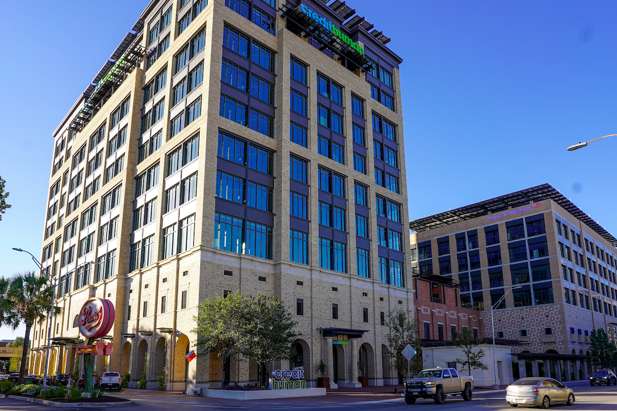 Credit Human Federal Credit Union’s headquarters at 1703 Broadway in San Antonio sets a new standard for sustainable commercial buildings in Texas. (Credit Human)
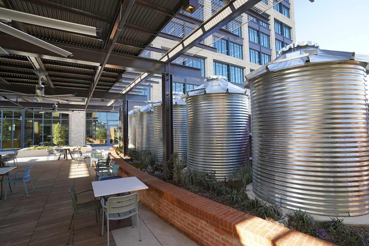 A combination of rainwater capture, storage, and reuse systems make the Credit Human headquarters one of the most water-conscious developments in Texas. (Credit Human)